Monday, December 8, 2008

Sulphur Springs Festival Of Lights..........


This past Saturday Night it was my pleasure to be invited to the 1st annual Festival of Lights Christmas Parade in Sulphur Springs. I was fortunate enough to be asked to be one of the judges for the parade and let me tell you, it was not easy. There were so many beautiful floats throughout the night it was hard to choose a winner. I wanted to share a few photos from the parade and let you know who the winners were. In the commercial division the winner was the Sulphur Springs Hardware. In the non-profit division the winner was the Hopkins County Dairy Festival Queen’s Float. And in the battle of the bands, DeKalb High School took home the prize. Thanks again Sulphur Springs for a fun festive night to get everyone in the holiday spirit.


Severe Weather Possible This Evening.......

A strong storm system is beginning to develop out to our west and will move through East Texas this evening. Ahead of this storm system, strong southerly winds will increase today bringing warm moist air into the region. Winds could gust as high as 30 mph today as a cold front approaches. Showers and thunderstorms will begin to develop this evening and a few of these could be strong to severe. The wind fields in the atmosphere are set up to where we could see severe wind gusts and marginally severe hail, around the size of dimes. There is also a slight chance that a weak tornado or two could form as these storms move through so everyone needs to pay attention to the threat of severe weather this evening and overnight. Our cold front will slide through around Midday tomorrow bringing an end to the threat of severe weather and also bringing much colder temperatures. Temperatures Tuesday night into Wednesday morning will drop into the lower to middle 30s. At the same time a weak disturbance will move into East Texas but with limited moisture, we are not expecting much in the way of precipitation however, there could be a flurry or two in our extreme northwestern counties, mainly from Emory to Sulphur Springs northwest. So a busy 48 hours is in store weather wise for East Texas.

Tuesday, November 25, 2008

The Big Holiday Travel Weekend..........

Travel Weather......

Click On A Region To Go To The National Weather Service


It looks as though Mother Nature will cooperate with your travel plans on what is traditionally the busiest travel day of the year, the Wednesday before Thanksgiving. Most of the country will be under the influence of a large ridge of high pressure keeping the weather fairly quiet. There will be a few exceptions to this. The Northeast will see cold and snowy weather as a disturbance moves through the Great Lakes into New England. Also, there will be an area of low pressure causing rain across Southern California and parts of the Southwest United States. The trip home right now looks good but there is a slight chance we could see some travel headaches Sunday. Some of our computer models have been hinting at a developing area of low pressure along the Northern Gulf Coast. If this does occur, there could be some cold rain across the Gulf Coast States Sunday. Right now the possibility of this occurring look pretty slim but, it is something we will need to watch.


U.S. Gas Prices.......

Click Here For Nationwide Gas Prices

Some great news for holiday travelers this year in the form of cheaper gas. Gas Prices continue to drop across the country with gas reach under $1.30 a gallon in parts of Missouri and South Carolina. You can track the price of gas where you are traveling this year by clicking on the map above. The link will take you to gasbuddy.com where you can right click on the area of the United States you will be traveling to see what the average price of gas is in that location. Bookmark this site so you can keep up with gas price trends any time you would like.

Flight Information.......

Click To Go To The FAA Official Flight Delay Site
Above is an image that shows the current amount of planes in the air. Click on the map to go to the FAA’s official flight delay map where you can click the region of the country you are traveling to and find any delays.

Monday, November 10, 2008

Severe Weather Possible Today.......


Severe Weather is possible across a good bit of central and east Texas today as a strong low pressure system develops to our northwest and moves across the Plains later today. The main threat of severe weather at this time appears to be large hail and strong winds however a tornado threat is beginning to take shape across Central Texas for later this afternoon. A warm front is beginning to move north across South Central Texas this morning and will continue on its northern track throughout the evening hours. It is along this front where we are seeing the strongest amount of wind shear, or winds of different directions and speeds as you move higher into the atmosphere. As storms fire in this area, they will begin to rotate and could produce isolated tornadoes. The afternoon tornado threat is dependent on surface temperatures this afternoon. If we can see a little sunshine and temperatures warm a few degrees more than what we are forecasting, then the chances of severe weather and tornadoes will increase. It is the warmer surface temperatures that will allow the updrafts for the developing storms to be rooted near the surface giving a chance for a few tornadoes to form. If surface temperatures stay cool enough, most of the developing thunderstorm updrafts will be above the surface layer, making it hard to produce tornadoes. But even with these storms, hail and high winds could be a threat.

Monday, October 20, 2008

The Second Severe Weather Season…..

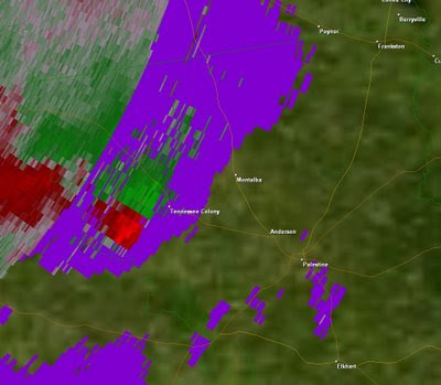
Monthly Tornado FrequencyAs we leave Summer and head into fall, we enter a secondary peak in the severe weather season, usually not as great as our primary severe weather season in Spring but, there have been some historical severe weather events across Texas and the United States this time of the year. Over the next few months we will be looking at a few historical fall severe weather events and local fall severe weather events here in East Texas. The fall severe weather season got off to an early start this October as we saw four tornadoes touch down across East Texas on the 6th of October, two near Montalba in Anderson County, one near Bullard along the Cherokee Smith County Line, and one in Cass County southeast of Atlanta.Montalba Severe ThunderstormVelocity Data.  Green shows winds moving towards the radar, red away.  This image shows rotation(possible tornado) near Tennessee Colony.An area of low pressure formed across Oklahoma Monday morning and moved east across the state dragging a cold front across East Texas. This brought Southerly winds at the surface and Westerly winds aloft causing the atmosphere to be favorable for rotating thunderstorms and the possibility of tornadoes. The severe Storm Prediction Center outlooked most of East Texas for a slight risk of severe weather and tornadoes.

Around 6 PM a severe thunderstorm developed across over western Limestone county and began to show signs of rotation. This storm continued to move northeast into East Texas, producing three of the four tornadoes for the day. Another tornado formed Earlier Monday afternoon in a severe storm that formed over Cass County.


This week is looking active as well. A strong upper level low pressure system will move north of our region dragging another cold front through East Texas. Right now it looks as though the best dynamics needed for severe weather will move into our region after the cold front moves through, meaning the chances of severe weather are pretty slim however, heavy rain could be a threat with this next system. We will watch it closely because if upper level dynamics move into our area while we are still ahead of the cold front, we could see a round of strong to severe thunderstorms with the chance of isolated tornadoes.

Stay Tuned………………………..

Friday, October 17, 2008

Winter is Brewing

A very pleasant air mass will be in control of our weather over the next few days. Fantastic temperatures with most areas dropping into the upper 40s tonight and tomorrow night with a light Northeast Wind. With dry air in place and mostly sunny skies temperatures will warm into the upper 70s each afternoon this weekend. Cold air continues to develop in the northern latitudes of North America.Temperatures over the Greenland Ice Cap could dip to near 60 below zero over the weekend. The image above shows forecast surface temperatures at 1:00AM CDT. Notice a large area of dark blue and purple across the northern sections of the continent. This indicates a large area below freezing and some areas close to 0 degrees. The little spec of yellow, in the top center of the image surrounded by purple, shows temperatures between 60 and 65 below zero over the northern ice sheet of Greenland. This is the start of the foundation of cold air that will eventually move south across the United States. Of course, we will not see temperatures near that cold but, it is a sign that winter is not too far away.

Monday, September 22, 2008

The Seasons of Change..............


As of 10:44am Central Time, we said good bye to the Summer of 2008. It is at this time we experience the Autumnal Equinox marking the beginning of Fall. Today the sun’s direct rays hit the Earth at the Equator and continue to move south until the first day of winter, when they begin to move back to the north. The sun will set today at the North Pole and will not rise until the first day of spring 2009, leaving the North Pole with six months of darkness. At the same time, the sun will rise at the South Pole and not set until the first day of spring. Another interesting fact, places along the Arctic Circle will lose around 15 minutes of daylight per day until the first day of winter, when the sun will set and not rise for nearly 24 hours. At the same time, places near the equator in the northern hemisphere will lose only a few seconds of daylight per day until the first day of winter. This is all caused by the 23.5° tilt to the Earth’s axis, which leads to the seasons we see throughout the year. If the Earth did not have this tilt, we would have no seasons on Earth and the weather would be, well, kind of boring. So nights are getting longer, temperatures will begin to drop, and it won’t be long before winter is knocking on our door.

Tuesday, September 16, 2008

The Mendoza Line.........

We have been rather busy in the weather office so I have not have time to keep everyone up to date on my big weight loss plan. I have now moved south of the Mendoza Line weighing in at 198 pounds, that’s 28 pounds I have lost since starting the Atkins Diet back in late July. Only 23 pounds left until I reach my goal of 175 pounds. During this time I have not deprived myself of great tasting food. Be sure to join me this week on “In The Kitchen” this Friday when I will be cooking one of my favorite meals I have prepared while living this lifestyle.

Cool Dry Air Moves In.....


No your eye’s are not deceiving you, our local weather net sites this morning were reporting temperatures in the upper 40s. Most of East Texas woke up this morning with temperatures in the low to mid 50s, a refreshing change from the muggy 70s we have been waking up to the past few weeks. This week’s weather looks to be near perfect with dry conditions and highs in the low 80s.

Thursday, September 11, 2008

Latest On Ike............................


Hurricane Ike promises to bring wild weather to East Texas Saturday into Early Sunday. The current forecast track has Ike crossing the central part of East Texas Saturday Afternoon. The large wind field associated Hurricane Ike will bring widespread strong gusty winds and possible power outages. There is also a good chance that Ike will produce isolated tornadoes across East Texas Friday Night into most of Saturday. The good news, if any, is the fact Ike will begin to move rapidly through East Texas. This will keep total rainfall amounts much lower than they could be, mainly 2 to 4 inches with a few isolated spots in our eastern counties nearing 6 inches.
Ike is having a hard time developing this afternoon due to its unique structure. Ike actually has two areas of wind maxima, eyewalls, with winds near 100mph. It’s the outer wind maxima that is inhibiting the inner eye to strengthen to level we would expect with low sea level pressure Ike has, around28.00” of mercury. Also, this second eyewall is helping spread out Ike’s wind field. Tropical storm force winds extend nearly 300 mile from the center this afternoon. So as Ike approaches the coast early Saturday morning, up here in East Texas we will begin to fell tropical storm force winds.
The possibility of tornadoes with Ike will be greater than we see with most tropical systems. With Ike’s large circulation, there will be a great deal of wind shear, winds blowing at different speeds and directions, over a large area of Texas. It is this wind shear which causes the storms to spin as they develop in the outer rain bands, making tornadoes a distinct possibility. Past hurricanes with wind fields this large have been prolific tornado producers. Hurricane Beulah (1967) produced 117 tornadoes with five of them being an F-3 in strength and one an F-4 but I doubt we will see this many because of the rapid movement. We will all have to monitor this situation very closely through the weekend.

Sunday, September 7, 2008

Ike Changes His Mind.......


Hurricane Ike continues to spin in the Atlantic near the Bahamas this morning as a strong category four storm. Ike is expected to make landfall as a strong category 4 storm with top winds near 145 mph along the Cuban coast Monday morning. Latest long range computer models do not bring as strong of a trough as we were forecasting last week across the Plains States and this could be some bad news. Ike is now expected to move across most of the Gulf and could make landfall anywhere from Houston to Panama City. I still look for Ike to turn north and miss the Texas Coast but, we will have to watch Ike closely because last Thursday it looked very likely that he would turn north and maybe miss the US East Coast. Stay Tuned……………………….

Thursday, September 4, 2008

The Peak of Hurricane Season


The peak of the Atlantic Hurricane Season is nearing and on cue, the tropics are heating up. After Hurricane Gustav hit the Louisiana Coast this week, three more tropical systems threaten the East Coast over the next week. The first threat is tropical storm Hanna. Hanna has been struggling over the past few days, once a category 1 hurricane. Hanna looks to intensify once again to a category 1 hurricane by Saturday before skirting the East Coast this weekend. Hanna could stay just off shore causing hurricane strength winds along most of the East Coast this weekend. Now Hanna will only be a minimal hurricane with top winds of 75 mph to 80 mph.

Ike on the other hand, is a dangerous category 4 storm this morning with top winds of 145 mph. Ike will be entering an area of cooler waters thanks to Hanna, causing the storm to weaken to a strong category 2 or 3 storm. Once Ike crosses the patch of cooler water, he should once again strengthen to a category 4 storm with top winds of 140 mph. Ike will have to be watched closely because he is forecast to move towards the East Coast of Florida as a very dangerous storm. Long range computer forecast models are hinting at a fairly strong cold front moving into the Midwest next Thursday. There is a chance this front could cause Ike to turn more to the north and then northeast, having him miss the US. Let’s all hope and pray this is the case.


And then there is Josephine. Josephine is having trouble gaining strength and it is doubtful she will ever make hurricane strength. Ike has stirred up some cooler waters from the depths of the Atlantic. It is this cooler water that Josephine will have to cross, along with some wind shear, causing Josephine to struggle in her development. Current forecast models continue to send Josephine out into the central Atlantic.

Saturday, August 30, 2008

Hurricane Gustav now a Cat4!!!!


Now Gustav has exploded from a tropical storm to a category 4 hurricane in less than 24 hours.

Latest Advisory from the Nation Hurricane Center:

DATA FROM AN AIR FORCE RECONNAISSANCE AIRCRAFT INDICATE THAT
GUSTAV HAS CONTINUED TO STRENGTHEN AND NOW HAS MAXIMUM WINDS
NEAR 145 MPH...230 KM/HR WITH HIGHER GUSTS. THIS MAKES GUSTAV AN
EXTREMELY DANGEROUS CATEGORY FOUR HURRICANE ON THE SAFFIR-SIMPSON
HURRICANE SCALE. A SPECIAL ADVISORY WILL BE ISSUED AT ABOUT 200 PM
EDT TO MODIFY THE INITIAL AND FORECAST INTENSITIES. THE SPECIAL
PUBLIC ADVISORY WILL TAKE THE PLACE OF THE INTERMEDIATE PUBLIC
ADVISORY PREVIOUSLY SCHEDULED FOR THAT TIME.

Gustav Explodes


Gustav explodes over night like expected. Gustav increased in strength from a tropical storm to a category 3 hurricane in less than 18 hours. That is almost unheard of. Gustav’s rapid intensification has calmed down a bit but, he could be a Category 4 before hitting Cuba. The southern end of Cuba will not weaken Gustav too much. He will probably emerge in the southern Gulf as a strong Category 2. From here he will cross the southern loop current in the Gulf. I would not be surprised if we were looking at a Category 5 storm late Sunday in to Monday. Now I still believe Gustav will weaken before hitting the coast, more than likely a strong Cat 2 or a weak Cat 3. Most of the computer models have come to an agreement of bringing Gustav onshore just west of Lafayette LA. A few are beginning to hint that Gustav could stall right before hitting the coast and then move southwest into Mexico but this guidance is in the minority.

Thursday, August 28, 2008

The Potential Effects of Gustav


Gustav has the potential to be a very dangerous, land falling hurricane early next week across parts of the Gulf Coast States. Gustav spent most of yesterday over the southeastern tip of Haiti causing the low levels of the tropical system to weaken and become disorganized. At the same time in the upper levels of the atmosphere, conditions seem favorable for development. Hurricane hunters found a surprise with Gustav this morning, the center of the storm had reorganized farther to the southwest over the warm waters of the Caribbean causing the winds to jump to near hurricane strength once again. Gustav could become a hurricane later today but he has one more obstacle to overcome, Jamaica. The current forecast track takes Gustav over the small island and this could once again disrupt the organization of Gustav today. Once Gustav moves away from Jamaica, conditions appear favorable for rapid intensification. Very warm waters and favorable upper level atmospheric conditions will allow Gustav to become a strong hurricane before reaching the Gulf of Mexico. As Gustav crosses the Southern Gulf of Mexico he will cross a region know as the Southern Gulf Loop Current. This is an area of very warm water not just at the surface, but down to a depth of 200 to 300 feet. It is this area of deep, warm water that has caused many storms to explode in strength if the conditions for development are favorable. Some storms of note that have exploded in intensity over this region are Opal of 1995, Katarina of 2005, Rita of 2005, and Wilma of 2005. The image below shows the Southern Loop Current. Notice the bright red colors. This shows water temperatures between 88°F and 90°F, giving a lot of fuel for Gustav’s development.


So the big question is where will Gustav go? Forecast tracts have consistently sent Gustav to the Louisiana Gulf Cost sometime late Monday or Early Tuesday. Right now there is a ridge of high pressure located over the Eastern Gulf of Mexico and this is forcing Gustav to move west. Over the next couple of days we expect this area of high pressure to weaken, allowing Gustav to turn more northwest. The farther west Gustav moves before turning to the northwest, the farther west the eventual land fall will be. Another big factor on where Gustav will go is an area of high pressure that will develop across the Ohio Valley Sunday. Gustav will be forced along the outer edge of this area of high pressure. The stronger this high pressure, the farther west Gustav will go. The image below is the current forecast track from the Nation Hurricane Center.


One not of interest, the average error for day five for a tropical systems location is 300 miles. So everyone with interests along the Gulf Coast, and with current fuel prices that is everyone, should continue to monitor Gustav.

Thursday, August 21, 2008

Where are you going Fay?


That is a question we will be answering over the next few days. Right now it appears Fay will drift west across the Florida Peninsula and then the Panhandle. The big question is will she move far enough south, over the Gulf, allowing Fay to strengthen once again, possibly into a hurricane? The image above shows the forecast tracks from various computer models the National Hurricane Center uses to determine their official track. As you can see, the majority keep Fay right along the Florida Coast. This would not allow her to strengthen and more than likely Fay would remain a depression. You can also see that one of the models, the Navy’s GFDN (Dark Blue), their tropical cyclone forecast model, tracks Fay across the northern Gulf. This is a worst case scenario. Fay would more than likely become a hurricane over the warm Gulf waters and head in the direction of New Orleans.


Ultimately Fay’s track will be determined by the overall atmospheric pattern and steering currents. Currently, a large area of high pressure is off the New England coast acting like a brick wall, not allowing Fay to move north. The outer edge of the high will steer Fay to the west over the next couple of days. There is also a trough of low pressure over the Northern Plains that could turn Fay north into the Tennessee and Ohio Valleys but, this trough will be replaced by another area of high pressure beginning next week. It is this second area of high pressure that will have the greatest effect on Fay’s future. If the high strengthens fast enough, Fay will remain on a southern track and could move as far west as the Texas Gulf Coast. If the high remains a little weaker, the Fay could squeeze between the two areas of high pressure, staying over land, weakening, and then being picked up by the continental westerly winds. The second scenario seems more likely at this time but, Fay has been surprising everyone so we will be watching this situation very closely.

Wednesday, August 20, 2008

Interesting Fay............

To say Tropical Storm Fay is a unique system would be an understatement. Fay is one of the rare tropical systems that actually strengthened as she moved on land. Early Tuesday Morning, Fay came ashore near Cape Romano, FL, about 20 miles south of Naples with top winds of 60mph and a rather rugged eye wall structure. However, Fay’s eye wall structure became much better organized while over land just south of Lake Okeechobee. In fact, Doppler radar indicated a well defined eye for Fay with winds close to hurricane strength before moving over Lake Okeechobee. The official statement from the National Hurricane Center showed the winds increased from 60mph to 65mph while over the mainland. So how did this happen? Tropical Storm Fay has two things working in her favor as she made landfall. First, the topography of South Florida which consists of the Everglades, a flat grassy wetland area, reduces the amount of friction the storm will encounter leading to a lack of weakening. Second, the upper levels of the atmosphere were very conducive to tropical storm development by providing Fay a large area of upper level outflow, allowing the storm in the lower levels of the atmosphere to strengthen. Notice the radar loop of Fay over South West Florida showing a symmetric eye wall, a sign of a strong tropical system.


Doppler radar velocity data indicated winds of nearly 70 knots, approaching hurricane force. The strongest surface wind reported during Fay was 78mph on the western shore of Lake Okeechobee at Moore Haven. Also, the water temperature in Lake Okeechobee is nearly 92°F, which could also add to the sustained strength over South Florida.

So where will Fay head next? Well it all depends on a developing area of high pressure over the Mid West this weekend. All indications are Fay will turn to the west and move across the Florida Panhandle, this will keep her circulation over land not allowing her to strengthen. There is a chance that her circulation could move back over water in the northern Gulf. The water temperature here is in the upper 80’s so if this does happen, rapid intensification could occur. It does appear the chances Fay, whatever becomes of her, making it into East Texas are very low. More than likely Fay will be picked up by a through early next week and move over the Mid West into the North East.

Thursday, August 14, 2008

My Big Weight Loss Plan.........

Well, another week has gone by and three more pounds are gone. At 207 pounds, this is the lowest weight I have been in over two years. I also went to my doctor this week and got some great news. In six weeks my cholesterol has dropped 94 points. That’s right, 94 points!!! My blood pressure has dropped significantly as well, although it still needs to come down just a bit. I have added a very tasty low carb meal on the recipe link to the right of the page. Just click on the picture and look for the Blackened Redfish recipe. Feeling great and look forward to dropping below the Mendoza line, for all you baseball fans, in a couple of weeks.

Wednesday, August 6, 2008

My Big Weight Loss Plan.....................

Just wanted to post an update on my progress with the Atkins Diet. I have now lost a total of 16 pounds in my first two weeks on the diet, down to 210 pounds. Only 35 more pounds to go until I reach my goal weight of 175 pounds and 45 pound until my ideal weight, 165 pounds. After two weeks on the plan I find myself having more energy during the day and not feeling hungry between meals. Sometimes I even find that I have to force myself to eat due to a lack of appetite. This surely wasn’t the case two weeks ago when I was constantly looking for something to snack on between meals. As for my meals, I have been enjoying a great variety of food. I will start adding low carb recipes to the “Grant’s Menu Link” soon. Check back from time to time to see what great tasting entrees are leading to my weight loss.

Thursday, July 31, 2008

The Derecho!!!!!


As we wait and wish for showers and thunderstorms, parts of the country are getting rocked with severe weather today. A classic wind storm across the upper Midwest known as a Derecho is causing a great deal of problems for our friends to the north causing numerous wind reports in excess of 80mph and very large hail, up to baseball size, have been reported. Below is a short radar clip of the Derecho as it moves into Western Minnesota.


Many times Derechos develop form a single Supercell thunderstorm that becomes outflow dominate, undercutting the updraft needed to sustain the Supercell. Along this outflow boundary, new storms fire and continue to grow in strength. As the system grows, the speed it travels increases and widespread wind damage can occur. Winds as high as 100mph to 120mph can occur along a Derecho causing tornado like damage. In many cases, the Derecho is worse than many small tornadoes as much of a Derecho’s wind can be in the EF-2 tornado range. Imagine a swath 50 to 100 miles wide of EF-2 tornado like winds. Damage can be tremendous. Also, many times on the north end of the Derecho, a rotating comma head can form producing small tornadoes. In the clip above you can make out a rotating comma head. There were numerous tornado warnings along this line in the area of that comma head. An event very similar to this occurred earlier this year with an EF-1 tornado in Kilgore and Longview. A bow echo moved through with a rotating comma head producing a 21 mile long path of EF-0 and EF-1 tornado damage. There have been many Derecho events across the Southern Plains. For more information on historic Derecho events click the link below.

More Info

Wednesday, July 30, 2008

Hello Dolly?????

The remains of Dolly could bring some much needed relief over the next couple of days. The moisture from Dolly is causing heavy rain and flooding conditions across Missouri today. The center of what once was Dolly is located over Kansas this morning and she continues to move to the east. A trough of low pressure extends south into North Central Texas today and this could cause a few showers and storms to form today across our North West Counties. This trough will slowly move across North Texas giving a few some much needed rain. There is a slight chance that the remains of Dolly could continue riding the ridge of high pressure and enter the Eastern Gulf of Mexico late this weekend. Indications are this moisture could move westward and reach East Texas by next Wednesday. Again, the chances of this occurring are pretty slim as it looks as though the remains of Dolly are getting caught up in the westerly flow, carrying her moisture away from East Texas.

Saturday, July 26, 2008

My Big Weight Loss Plan........

As many of you can tell, I have been struggling with my weight the past year. There has been a lot of debate the last couple of weeks on which of the three “Big Diets” work the best, a low carb, a low fat, or a Mediterranean diet. I can tell you from experience, that the low carb, or Atkins Diet, worked for me. A few years ago while working in the restaurant industry, a few managers got together to have a competition on who could lose the most weight. The winner would win $500. So at 205 pounds, I entered the contest, I am a very competitive individual. The weight loss contest began in late April. By the end of June, the contest ended and I had slimmed down to an amazing 159 pounds, my wife said I was too skinny. All though the money for the contest was never paid, I gained a much healthier life style, my blood pressure was low and, my cholesterol was at a healthy level again. So I really didn’t mind not getting the money.

I continued to live this healthy life style until I was hired for a new position in which I had to spend a lot of time on the road. Fast food became the regular and the weight piled back on and I have struggled ever since. Two weeks ago I went to the doctor and reached a new peak weight, 226!!!!! My blood pressure is way up and my cholesterol is at an unhealthy level. That did it! I decided to go back on the Atkins diet and this time, I have you to hold me accountable. So I am here to tell everyone my goal weight and will keep you updated with what I eat and my weight loss progress. From time to time I will put some of my favorite low carb recipes on this blog too. This morning I weighed 215 pounds, that’s eleven pounds that are gone for good. My goal weight is to reach 175 pounds by Christmas but I hope to continue to drop down to 165. Hopefully, you will notice a big change in my appearance over the next few weeks.

Friday, July 25, 2008

Dangerous Heat Possible


The hottest temperatures of the year so far are expected to greet East Texas this weekend as many locations could top the 100 degree mark. Another strong, mid level, ridge of high pressure is building across the state keeping conditions mainly dry and hot. This is not good news for Texas as much of the state is once again under drought conditions. Many towns across East Texas have already placed outdoor watering bans into effect, and more will probably follow. According to the Keetch-Byram Drought Index, which measures drought severity on a scale from 0-800, 800 being the worst, most of East Texas is beginning to experience another drought. The chart below shows the KBDI readings between 400 and 800.


Outdoor burning will also become a problem this weekend as very hot and dry conditions dry out vegetation across our region. Temperatures will average between 98and 101 degrees this weekend with heat index values close to 105, the danger category for being outdoors. The heat index is a value used to determine how your body will react to the combination of air temperature and the amount of moisture in the air. The more moisture that is in the air, the harder it is for your body to cool itself because it takes much longer for your sweat to evaporate, cooling your skin. This also causes you to become dehydrated faster because it takes more of your bodies fluids to create a cooling effect. Below is a chart you can use to determine what the heat index is where you live.


So if you have to be outdoors this weekend, remember to drink plenty of water, soda and alcohol can cause dehydration. Also, don’t forget the sun screen. Take it from me, you do not want your scalp to burn, it is no fun. The best thing to do is to stay in an air conditioned environment, maybe take in a movie?

Tuesday, July 22, 2008

Dolly, Please Bring Rain!!!


Dolly is expected to hit the Gulf Coast near Brownsville, TX around Midday tomorrow as a Category 1 hurricane. Very heavy rain and strong gusty winds will occur across south Texas over the next couple of days but over our region of the world, the heat continues. Now there is some good news for East Texas. Dolly will wrap some moisture back into our region starting tomorrow so our chances of afternoon and evening thunderstorms will increase. This will also cool our temperatures a bit over the next couple of days. However, our strong ridge of high pressure that has been dominating our weather will continue to push Dolly off to our south and build back into our region, heating us back up for the weekend. We could be entering a period of extended dry weather with our only chances of rain coming from isolated afternoon thunderstorms. There are signs that our weather pattern could change towards the end of July but, until then it looks hot and dry for at least the next week after Dolly’s moisture leaves East Texas.

Friday, July 18, 2008

The Legacy of Bertha


The longest lasting July tropical system on record is still holding her own in the North Atlantic. Tropical Storm Bertha, once a category 3 hurricane, has been going strong since July 3rd when she formed off the African Coast. If you think you remember a Bertha from earlier years, you would be correct. In fact, there have been six tropical systems named Bertha in the Atlantic Basin, three reached hurricane strength. The last Bertha to form was a tropical storm in 2002 that affected the Louisiana and Texas Gulf coast with heavy rains and top winds of 40mph. The National Hurricane Center recycles the names of tropical systems until a storm causes significant loss of property or life, and then the name is retired. There is a chance Bertha may finally be retired, not because of her destruction, but because of her records. Not only is Bertha the longest lasting July tropical system, she is also the farthest east pre-August forming tropical system and major hurricane on record.

Wednesday, July 16, 2008

Global Warming, Is the Debate Over?


Global Warming Catastrophe Alarmists would have you believe the debate is over. There is no doubt the world is warming and man is to blame. If we do not change our ways the earth as we know it will cease to exist. Many cities today will be under water. Hurricanes and tornadoes will become much stronger and occur more frequently. We have all heard this because the “main stream media” loves to promote Armageddon. But what do that facts state? Well over the next few days I plan to point out a few facts you may not have heard so you can draw your own conclusion on Global Warming.


“Climate Change to Spur Extreme Weather”
This is just one of the many News headlines you have read or seen about the effects Man Made Global Warming will have on the Earth’s climate. Well I want to dive into this spring’s active severe weather and flooding so everyone can get a better understanding on how storm systems work and what causes them to be so severe. We have all heard about how bad this year’s tornado season has been and how many climatologists are blaming Global Warming for the severity of the tornadoes this year. I think a better argument is many ingredients have to come together to produce severe storms and tornadoes and this year, the ingredients have come together more than in previous years, but why? This past May was actually the 4th coldest on record during the satellite era, the same time period Climatologists have been studying the warming of the Earth. During May, the Rocky Mountain States along with the Northern Plains and Canadian Provinces have been much cooler than normal. At the same time, the Bermuda High, an area of high pressure that forms over the Atlantic during the summer months, has built in across the Southeastern United States. This has pushed the average storm track to the north across the Midwest and Plains States. Now the fact that May’s Temperatures in the northern latitudes have been cooler than normal has lead to a greater temperature gradient than normal. This has allowed the Jet Stream to be much stronger than it usually is this time of the year causing the numerous outbreaks of tornadoes. This has also lead to a large amount of rain to fall over the same areas, causing very bad, if not record flooding in some areas. So before we blame these events on Global Warming, let’s all understand better what set these chains of events in motion.

Tuesday, July 15, 2008

To Drill or Not to Drill


The great debate over our energy need has become the number one issue facing the American Public today. Now it is up to Congress to decide whether or not we can drill for oil off of our own coast lines. Now I am in no way an expert in economics but I do have an opinion on how drilling for oil off the United States Shores and other places in our country will affect the price of gasoline at the pump. The price of oil continues to climb with no end in site mainly, in my opinion, due to speculation on the fact that we have no concrete plan to terminate our dependency on foreign oil. By formatting a plan to stop our dependency on foreign oil, the price of oil will drop, regardless of the fact it will take up to ten years to see any oil from our new drilling sites.

So why can’t we drill in more locations off our coast acquiring an extra 80 billion plus barrels of oil? The main arguments have been maintaining a pristine marine environment and needing to develop alternative, reusable energy sources. Now I am a firm believer in developing new sources of energy but, this will have no affect on the price of gas now. We are at least ten years away from everyone being able to afford hybrids and hydrogen cell vehicles so in my mind that argument does not work. As for keeping a pristine marine environment, offshore oil rigs provide artificial reefs which allow marine life to flourish. In most cases, within six months after an offshore rig has been placed, a thriving ecosystem develops with all forms of marine life. Before rigs were placed in the western Gulf of Mexico, the marine life was rather scarce, now some of the world’s best fishing and diving is near and around these rigs. What about the amount of oil which leaks in the Seas while drilling? Well, this amount fails in comparison to the amount of oil which naturally seeps into the oceans. 180 million gallons of oil naturally leak into the world’s oceans, making up near 62% of the total amount of oil in the Seas. The percentage of oil from oil platform leaks, less than 1%. Now I by no means believe we can drill our way out of our energy crisis but, I do believe we can lower the cost of our energy through drilling while we develop new and reusable forms of energy.

So in my mind, it is a no brainer………………..Drill now!!!!!!!