Friday, March 30, 2012

Severe Storms Possible Northwest of Dallas


There is a conditional chance of severe storms across parts of North Texas and Southern Oklahoma this afternoon. Forecast sounding near Wichita Falls show showing an extreme amount of instability that could lead to explosive thunderstorm development later this afternoon. The one ingredient lacking to prevent this from being a major severe weather outbreak is forcing to give lift to surface parcels which would in turn cause the storms to develop.

A dryline will be advancing eastward across northwest Texas later this afternoon. This could provide enough forcing to allow one or two isolated storms to develop, especially near the intersection of the thermal axis and moisture axis.

We can also see that surface moisture is forecast to be converging along the dryline which give added belief in the threat of thunderstorms development.

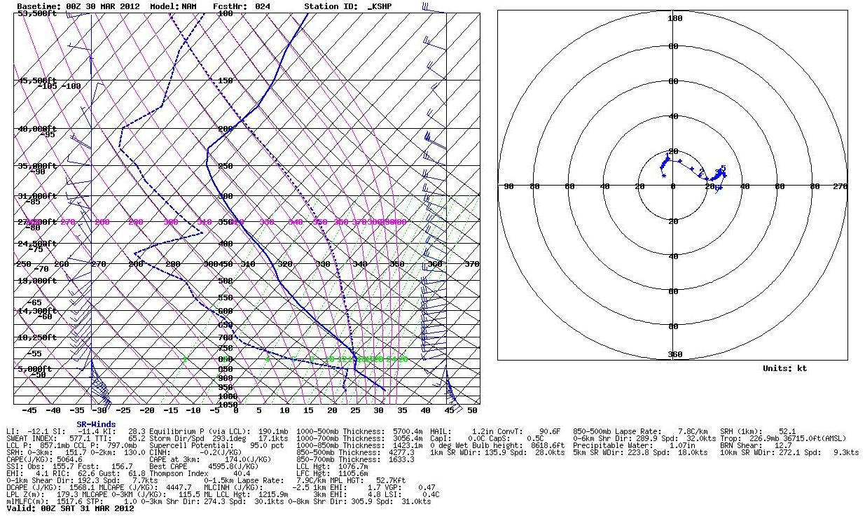
Now all of the area is under extreme instability with LIs running between -11 and -14 across all of north Texas and southern Oklahoma.

Over the same area however, there is a small cap. The lid strength index is positive over most of the area, greater than 0°. Usually a lid strength index less than 2° shows there is a chance the cap will break and allow scattered storms to develop. However, with the extreme lack in forcing the cap could very well win out today. There is forecast to be a small upper level disturbance move across this region later this afternoon. This could be just enough lift to take advantage of the extreme instability available.

Many times a weakness in the cap develops near the nose of the low level lapse rate axis. If this occurs today isolated storms could develop very close to Wichita Falls later this afternoon.


If storms do develop they will do so in an environment that is not only conducive for very large hail, overall high instability, but they could also produce an isolated tornado. The amount of 0-3km CAPE is approaching 200 J/kg in a few areas which will provide plenty of stretching potential of Strom Relative Helicity which could lead to tornadogenesis.

There does appear to be just enough low level storm relative helicity to introduce a tornado threat as well. So the next few hours will determine what if any storm can develop and whether or not I will be making the four hour drive to see what Mother Nature has to offer.

Wednesday, March 21, 2012

Cold Core Chase Today


All the ingredients are coming together for a cold core set up mini supercell event.The image above shows the surface features in conjunction with the 500mb low pressure. Looks to be a near classic cold core set up. Highlighted area shows where the best combination of parameters come together for supercell development.

Tuesday, March 20, 2012

Cold Core Set Up Tomorrow?


A cut off upper level low pressure could give parts of Texas a surprise severe weather event. High resolution models are trending towards a "Cold Core" set up where low topped mini super cells could develop tomorrow producing small hail, gusty winds, and possibly a tornado or two. Right now the Storm Prediction Center does not have this area under a risk of severe weather. These types of events usually don't materialize until all the mesoscale features come together so we really won't know what will happen until the set up begins to take shape tomorrow afternoon. Looking at the image above, the amount of surface based CAPE is nothing to get excited about. Nowhere do we find CAPE at or above 1000 J/kg.

However, the image above here shows 0-3km CAPE approaching 200 J/kg, which is large enough for rapid low level convection needed to generate storms.

When we look at a forecast sounding just south of Forth Worth we can see the majority of the CAPE is located in the lower levels of the atmosphere. In fact, the LIs are positive because all of the energy is located below the 500mb level. In addition, the wind shown on the hodograph turn drastically with height, in the levels where the CAPE is located. This is producing effective bulk shear on the order of 35 to 40 knots. So with enough forcing we could see a few storms develop and in this environment they would likely be low topped super cells. The sounding above shows the maximum parcel level to be around 28,000', not very impressive when you think of severe weather. Even though the CAPE is small, the majority is in areas below freezing thanks too the cold air aloft. So small hail would be likely.

The above image is a crude surface drawing showing you where surface features are forecast to be during peak heating in conjunction with the 500mb low. The forcing associated with this low should be enough for scattered storms to develop.

In the final image above, the high resolution WRF model is breaking out an arc of scattered cells around the forcing associated with the 500mb low. If this does occur in the environment the forecast sounding predicts, these will more than likely be low topped super cells. The tornado threat looks very low thanks to the fairly high cloud base the NAM is predicting. However, the LCL is as low as 915m on the sounding above which could lead to an isolated tornado if the surface environment sets up the way it is forecast by the NAM. Right now I look for the SPC to have a 5% chance of hail tomorrow across North Texas with no tornado threat during their first outlook. Once the surface features tomorrow afternoon are known, a 2% tornado risk may be introduced.

So What Happened With Yesterday’s Tornado Threat?

Yesterday much of East Texas was under a moderate risk of severe weather including a 10% chance of tornadoes, which is an elevated risk for tornadoes. We had strong southeasterly winds at the surface with strong westerly winds aloft giving East Texas a significant amount of shear and spin to the atmosphere. All that was missing was the energy to lift the air for convective initiation. If you remember from yesterday’s forecast sounding models were painting a pretty scary picture across East Texas. Temperatures were forecast to reach close to 80 degrees with dewpoints in the middle 60s. This provided a forecast Surface CAPE over 2500 J/kg.

With a little extra sunshine, drier air mixed down to the surface producing dewpoint about 5 degrees cooler than forecast. As you can see if we modify the forecast sounding with the actual dewpoints, the CAPE nearly disappears and the lower levels of the profile experience Convective Inhibition, or a cap.
So with the new cap in place any updraft that tried to originate was quickly forced down to the surface keeping thunderstorms from developing. Many times when everything points to a significant severe weather event, an unforeseen event puts the brakes on severe thunderstorm development.

Monday, March 19, 2012

A Moderate Risk for Severe Storms Including Tornadoes Today


There is a moderate risk of severe thunderstorms across East Texas today including the threat of tornadoes. A very warm and moist air mass has set up across East Texas thanks to 7 days of a southeasterly flow off the Gulf of Mexico. Dew point temperatures are forecast to peak in the lower 70s ahead of a developing line of thunderstorms. The image below shows most of East Texas covered in yellow meaning dewpoints will be at least 65 degrees providing plenty of energy for thunderstorm development.

The latest High Resolution Rapid Refresh model breaks out a broken line of thunderstorms later this afternoon heading towards East Texas. This will be the first round of at least three lines of storms that develop.

The 0-6KM shear available across East Texas is more than enough for the storms that develop to become supercellular. Shear values will be approaching 50 to 60 knots across the area allowing mid level rotation to form with any storm that develops.

As these rotating thunderstorms move into East Texas they will be encountering low level helicity levels that are conducive for low level rotation which could lead to tornadogenesis. The image below shows areas of light green and yellow out ahead of the storms show low level helicity between 200 and 300 m^2/s^2.

The environment also shows large hail to be very possible across East Texas this afternoon and evening. The forecast soundings for both Forth Worth and Shreveport show large amounts of CAPE in the hail growth region. With the high shear levels, ice particles we be in the hail growth region longer making golfball to baseball size hail possible with the strongest storms.

One thing you will notice is the winds are more favorable for tornadoes the farther east you go. The good news is the farther east the storms move, the less forcing they will encounter so they may begin to weaken just a bit.
It does appear after the first round of storms moves through, more storms will develop throughout the night and into tomorrow morning. Before the rain ends Wednesday much of East Texas will receive between 3 and 6 inches of rain with a few areas picking up over 8 inches of rain.

Thursday, March 8, 2012

Strong Storms and Heavy Rain Likely Today


A strong cold front was moving south across the Southern Plains this morning and will be moving into our northern counties later this afternoon pushing all the way through East Texas by Friday morning. Out ahead of this front showers and an occasional thundershower will develop this morning into the early afternoon hours.
By late afternoon as the front moves into the I-20 corridor during peak afternoon heating, there will be a chance of a severe storm or two. Right now the overall severe threat does not appear that great but the strongest storms will be capable of producing wind gusts to 60 mph and hail up to the size of quarters. The tornado threat appears to be fairly low today as most of the stronger storms will develop right along the cold front which will make the storms slightly elevated, thus not allowing them to ingest the surface air needed to produce tornadoes. However, if an isolated strong storm or two develops out ahead of the cold front, a tornado threat could develop briefly this afternoon.
Once the front moves through the threat of rain and thunderstorms will not end any time soon. An area of low pressure in the mid and upper levels of the atmosphere will keep southerly winds just off the surface forcing warm moist air to move over much cooler air at the surface as highs will struggle to reach the middle 50s. This will provide the perfect situation for an over running precipitation event starting tonight and lasting through most of Friday. Forecasts show an average of 1 to 3 inches of rain occurring with this event before ending late Friday.
Another disturbance will move to our north on Saturday providing the same type of over running precipitation event once again. This event will last through Saturday evening before a warm front is pushed north across the area Sunday morning. This will not shut of the rain either. An area of low pressure at the surface will surge north from the Gulf Coast into the Ozarks on Sunday. This will give East Texas another chance of showers and storms. Before all is said and done early Monday morning, much of East Texas could see at least 5 inches of rain with some local areas receiving up to 8 inches.