Monday, November 21, 2011

Today's Severe Weather Threat


A cold front is dividing the weather across East Texas today. Temperatures ahead of this front are already approaching 80 degrees while north of the front, many areas are in the lower and middle 50s. It is along and just ahead of this front where a severe storm or two may develop later this afternoon. North of the front we will see showers and storms develop as warm air is forced over the shallow cooler air at the surface. Any storms north of the front could produce large hail but with the lack of surfaced based instability, the wind and tornado threat is extremely low.

It is along and south of the front where the severe weather threat changes significantly to include the threat of tornadoes and gusty winds. The one factor missing to make this a significant severe weather event is enough lift out ahead of the front. The upper air disturbance this afternoon will be too far west to provide enough lift for wide spread convection but there will be a chance a storm or two could develop due to daytime heating.

If a storm can develop south of the front the environment the storm would encounter would be favorable not only for severe weather but tornadoes as well. MLCAPE approaches and surpasses in a few areas 1000 J/kg south of the front. This is more than enough energy to provide deep robust updrafts.

In addition to the MLCAPE being around 1000 J/kg, the 0-3 KM CAPE will approach 100 J/kg. This provides enough lift in the lowest layer of the atmosphere to stretch and tighten any surface vorticity which could allow for tornadogenesis.


In addition the effective shear in the warm sector south of the front approaches 60 knots. This shear will cause any robust updraft to rotate producing supercell thunderstorms. In addition to the effective shear being adequate for severe storms, the effective storm relative helicity is over 200 providing more than enough low level spin that when combined with the low level CAPE shown early could help with tornadogenesis.


So all the parameters are there for severe thunderstorms including tornadoes today but with the lack of real forcing, we will have to wait and see if a storm can develop. The Storm Prediction Center has areas immediately along the forecast position of the front under a 5% chance of seeing a tornado(now is only 2% based on the question will a storm develop). Again as the southerly flow hits the front and is forced upward, showers and storms will develop north of the front. There is enough elevated CAPE along with shear to cause rotating or supercell thunderstorms to form. However with these storm’s updrafts not routed in the surface layer of the atmosphere, tornadoes will not be a threat.

Monday, November 7, 2011

Strong to severe storms possible tomorrow

A strong storm system is developing to our west today and this system promises to bring some much need rain along with the threat of strong storms to East Texas. Rainfall from this system looks to be around an inch for most of East Texas as we see plenty of moisture available for numerous showers and storm.

Today as you step outside you will notice a warm and kind of muggy atmosphere. Strong southerly winds have brought a lot of Gulf moisture to the area keeping temperatures very warm at night and allowing for afternoon highs to reach the upper 70s to near 80 degrees for many areas. This moisture will set the stage for a significant severe weather outbreak this afternoon to our west. Areas to the northwest of Dallas and Fort Worth will see scattered severe storms producing very large hail and tornadoes this afternoon. If you had any travel plans to these areas today you may want to postpone them until tomorrow when the large hail threat will be much lower.

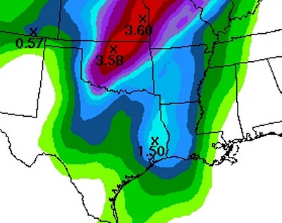
The scattered severe storms this afternoon will form into a line of storms as a fast moving cold front moves towards the area. This will cause the storms to race east and reach our area tomorrow around midday in our western counties and during the afternoon hours across our eastern counties. This line of storms could produce some small hail and gusty winds but the good news is they will bring heavy rain. Much of the area should receive around an inch of rain with a few spots receiving over an inch and a half of rain with this line of storms. The image below shows much of East Texas receiving between 0.75” and 1.50” of rain with this line of storms tomorrow.

By Tuesday evening drier air will be moving in behind a Pacific cool front. Temperatures on Wednesday Morning will drop into the 40s as the dry air cools overnight. On Wednesday another front will move through the area bringing cooler Canadian air into East Texas. This will allow morning lows to drop down into the 30s By Friday with a few spots getting close to freezing. The roller coaster ride of temperatures we normally see in November will continue.

Thursday, November 3, 2011

Wide Spread Frost Possible Tonight

A strong cold front moved through East Texas last night and you can tell, much colder air has moved in. The winds today will still be quite gusty out of the northwest around 20 to 25 miles per hour through the early afternoon hours. As the Canadian high pressure mov0se over East Texas late this afternoon, our winds will die down setting the stage for a very cold evening. By 10PM winds will more than likely be below 5 miles per hour in most areas with the exception being our higher ridge tops across East Texas. In the areas where the winds are below 5 miles per hour, temperatures will rapidly drop. At the same time dew point temperatures, or the temperature at which dew forms on objects, will be well below freezing, in the lower 20s in most areas. This will allow for any moisture that forms on outdoor objects to quickly freeze causing frost to develop. So if the winds do die down early enough most of East Texas will wake up to a frosty start on our Friday. If the winds do not die down below 5 miles per hour, wide spread frost will not form but I would still bring in any tender vegetation you may have.

With much of East Texas expecting frost tonight, some parts of East Texas could experience freezing temperatures towards morning. Again this all depends on the wind speed. With light winds temperatures are allowed to drop very rapidly and can approach the dewpoint. I would not be surprised if a few of our normally cooler locations in the morning dropped to near 30 degrees, possibly even the upper 20s. Freeze warnings have been posted for our northwestern counties but if it looks like the winds will die down early enough, those warnings may be extended farther south and east.