Monday, December 17, 2012

Severe storms possible Wednesday


A strong area of low pressure will develop along a cold front and move across East Texas Wednesday evening.  As it moves towards East Texas scattered strong storms will develop Wednesday night.  Right now the best timing on the front’s arrival is around Midnight Wednesday Night Thursday morning.   Behind this front, strong northwesterly winds will usher in some fairly chilly weather for the end of the week.

Right now the greatest threat of severe weather appears to be strong gusty as the mid level flow across East Texas will be between 70 and 90 miles per hour.  The taller storms will be able to tap some of this wind and bring it down to the surface.  So it does appear likely the stronger storms will be able to produce winds of up to 80 miles per hour across East Texas late Wednesday night in to Thursday morning.  So start to plan now to remove loose objects from the yard and maybe the inflatable yard Christmas decorations just in case.

The overall threat of tornadoes right now appears rather low.  There will be a lot of low level shear favorable for tornado development but with surface winds remain out of the southwest ahead of the front, the amount of low level spin for tornado development appears less favorable.  There maybe one or two brief weak tornadoes but at this time the winds damage threat appears to be the greatest across East Texas.  Stay tuned for the latest developments. 

Friday, December 7, 2012

Very Active Weather Pattern The Next Few Days

A strong polar front is diving south towards East Texas this weekend and will provide some active weather that includes a chance of rain, storms, and maybe even a flurry or two across parts of East Texas.    For all the snow lovers out there, don't get too excited because it probably won't happen but, the chance is not zero.  Here is what looks like may happen this weekend as of Friday morning.

Right now a weak cool front is located across north central Texas with an area of low pressure developing west of the Hill Country.  This front will drift towards the I-20 corridor before washing out Saturday night.  Now the forcing along this front providing lift is fairly weak but, there looks as though enough instability will develop across East Texas to where a thunderstorm or two could develop Saturday afternoon.  The atmosphere will be conducive for a severe thunderstorm or two as surface based instability will be sufficient for robust updrafts which could produce hail.  Surface based Lifted Index will be negative, approaching -5, allowing for strong updrafts to develop.

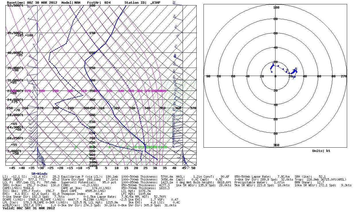
The winds throughout the atmosphere on Saturday appear as though they will be out of the southwest limiting the tornado threat.  The shear will be strong enough for an isolated supercell or two mainly along and north of I-30 Saturday afternoon so if there were to be an isolated storm that becomes severe this would be the most likely location.

On sunday a much stronger front will move towards the area allowing for a line of scatter thunderstorms to develop on move southeast across East Texas.  Like Saturday, the surface based instability will be more than enough for robust updraft development as the surface based lifted index will range between -4 and -6 across East Texas.


Now unlike Saturday, the shear across east texas will be more than enough for supercell development.  0-6km bulk shear will be around 50 knots which will allow for the atmosphere to provide enough shear for rotating updrafts increasing the threat of large hail.


The low level shear however will not be supportive for tornado development.  Again the winds throughout the atmosphere will be mainly out of the southwest limiting the low level spin available for low level mesocyclone development.  The 0-1km bulk shear will be around 10 knots which is not the optimum level for tornado development.  Although not unheard of the overall tornado threat will these perimeters is fairly low.


So we will probably see a line of strong thunderstorms move across East Texas late in the day in tot eh evening hours with a threat of strong gusty winds and hail.

After the front moves through MUCH colder air will move into the area.  There are now indications as well that an over running precipitation event could unfold on Monday.  This is because winds aloft will still be out of the southwest forcing warm air to lift over the colder air at the surface providing clouds and the possibility of precipitation for the morning hours.  It still looks as though skies will clear by Monday afternoon but even with the sun breaking out, northwest winds ushering in the coldest air of the season will keep high temperatures in the 40s for most of East Texas, possibly upper 30s across the I-30 corridor if the skies do not clear soon enough.


As for the chance of flurries across the I-30 corridor, the farther west you live, the better chance of seeing this occur, all be it the chance is VERY low!  It looks as though most of the precipitation that develops behind the front will evaporate before reaching the ground but across north central Texas, from Dallas , northwest, there will probably be a few flurries Monday morning.  If these flurries can hold together we may see a few make there way into the Greenville and possibly Sulphur Springs areas by 9 or 10 AM Monday.  This is a very similar set up to a cold front that moved through last December giving a few area of East Texas some flurries, our only winter weather event of the winter season.  If this does happen, and right now this looks to be a big if, there will be no travel problems what so ever, just an added chill to get you in the Holiday Spirit.


Wednesday, November 14, 2012

Sleet Last Night?

 That’s right.  A few areas of East Texas saw a mixture of hail, sleet, and graupel (snow pellets) late last night and early this morning.  So what happened?  Well a fast moving disturbance brought a lot of high clouds to the area last night and in a couple of areas these clouds developed into small thundershowers.  The image below shows the profile of the atmosphere early this morning.  Here we can see the cloud base was just over 10,000’ in elevation.  When air was lifted from this level it encountered elevated instability leading to the development of elevated showers and thundershowers.  Since most of the cloud’s temperature was below freezing, snow and snow pellets were forming instead of rain.  In the strongest updrafts the graupel, snow pellets, were held aloft allowing water vapor to freeze encasing them in ice until they grew too heavy for the updraft to hold allowing hail, some up to dime size, to reach the surface.

Outside the heavy core mainly snow and graupel feel from the cloud base where above freezing temperatures were encountered below 10,000’.  Here the ice crystals began to melt but not completely as the dry air began the process of evaporation.  As the precipitation evaporated it cooled rapidly allowing for the water droplet to refreeze into sleet.

In the lightest areas of precipitation most of the precipitation evaporated completely before reaching the ground.  The image above shows a radar shot of the shower across the Lake Fork area.  In addition to the precipitation the elevated instability allowed for the collision of ice crystals causing a large amount of static charge producing numerous cloud to ground lightning strike while over the Lake Fork area.

Monday, November 12, 2012

Henderson Mini Supercell


Sunday afternoon a small but intense thunderstorm developed across Cherokee and Rusk Counties that on radar showed what appeared to be weak but persistent rotation for over one hour as it moved northeast paralleling highway 79 south of Henderson then highway 43 north of Henderson. After looking at the radar data it appears we had a mini supercell develop across East Texas. The storm was never more than 5 miles across and stayed for the most part under 30,000’ in elevation. This is typically not the type of storm that would produce severe weather but in Sunday’s environment, this little storm was able to ingest a lot of low level shear and spin like a top as it moved across the landscape.

At 3:10PM Sunday afternoon the thunderstorm in question was located near New Summerfield in eastern Cherokee County. At this time the storm’s top was just under 20,000’ in elevation and had a reflectivity core of with a maximum of 54.5dbz under 10,000’. This indicated basically a heavy rain shower, more than likely not even producing any lightning. But at the same time the velocity data did show rotation up to 8000’ in elevation.

Now the rotation was by no means strong but was the beginning of a long lasting rotation that would last in this storm for over 1 hour.

At 3:44PM the storm in question showed an increase in the inflow velocity a sign that it could be attempting to produce a tornado. Again the rotation was not very strong but at this point it had lasted for over 30 minutes and was showing an increase in strength. At this time the core was 62dbz at 10,000’ but the top of the storm was just barely reaching 30,000’. It was probably producing a few lightning strikes but again it was nothing you would normally consider severe.


At 3:48PM is when the storm finally peaked showing its mini supercell characteristics. At this time there was rotation, again not very strong, but it was the tightest it has been the entire life span. It is also around this time when a very suspicious photo was sent to us showing what appears to be a well organized mini mesocyclone with a funnel cloud lowering towards the ground. As of this writing it is unknown if the funnel ever touched down to produce a tornado due to no damage reports being submitted.

As mentioned before, the rotation on radar was not particularly strong and thus really not considered to be a tornado threat. But when you look at the strength of the rotation based on the diameter of the mesocyclone, it is not out of the question that a mini supercellular tornado occurred. A study by the National Weather Service Shreveport in 1997 developed a chart for warning tornadoes during mini supercellular events. A nomogram was developed in 1997 as a guideline for issuing tornado warning based on the rotational velocity (the absolute values of the inbound and outbound velocities divided by two) in a mesocyclone. Based on the velocity data on Sunday the storm in questioned rotational velocity was between 15 and 19, well below the threshold guideline for issuing a tornado warning.

But what the study found in the case of mini supercells was the rotational shear (rotational velocity times 2 divided by the diameter of the mesocyclone) was a better indication of tornado development. When using the rotational shear we come up with a value of 12.3 near the time of the suspicious photo based on a mesocyclone diameter of only 1.59 nautical miles on radar at 3:48PM. This places the rotational shear in the tornado possible area of the rotational shear guideline chart.

Since the only photo we have has the bottom of the funnel block by trees, and we have had no damage reports from the area, we will never know if a tornado was produced. Hopefully a few more photos will surface that are not obscured by trees to give us a better view of what occurred.

Monday, November 5, 2012

Severe Weather This Weekend?

Long range models are still pointing to a very active weekend weather wise across the central portions of the United States. A deep trough will swing across the Rocky Mountains Saturday and move into the Plains on Sunday. This will cause a strong area of low pressure to develop and swing a cold front through the area. Now there are still some differences on the exact timing of the event, but confidence is rising with the threat of strong to severe storms across the mid section of the nation Saturday and Sunday.

Right now it appears two areas of low pressure will develop between Friday and Sunday across the high plains ahead of the aforementioned trough. This will cause strong southerly winds to set up all across the Plains States this weekend including East Texas. The second area of low pressure that develops near the Texas Panhandle Sunday will be the one that drags a cold front through the area with the possibility of strong to severe storms Sunday afternoon.

 Right now the limiting factor across the area in preventing severe storms will be the minimal amount of buoyant energy available for thunderstorm growth. Models are paining between 500 and 1000 J/kg of Mean Layer CAPE across the area and we would usually like that number to be greater than 1000 to get strong convection or storms to develop.
 But the surface based Lifted Index, or LIs, are all negative and approach -4, not extremely unstable but are significant when overall CAPE values are low.
 By looking at the profile of the atmosphere we notice the CAPE, energy for thunderstorm growth, is what we call short and fat.
 This means even though there is not a substantial amount of CAPE for thunderstorms the updrafts that do develop have the potential to be very strong. This would increase the threat of severe weather including hail and tornadoes.

 Now the wind shear available on Sunday in more than adequate for severe weather across the Plains. The overall bulk shear up to the mid level of the atmosphere is close to 50 knots in most areas and approach 70 knots near the Red River Valley.
We normally need to see around 40 knots to see supercell development, storms that are capable of producing very large hail and tornadoes. In addition, the 0-1km shear is on the order of 30 knots across most of the area.
Levels of 20 knots or greater are usually what we look for in tornado development. Third, the winds just of the surface will be between 50 and 60 knots so any thunderstorm downdraft could easily produce winds over 60 miles per hour.

So the winds energy is more than adequate for high winds and tornadoes if storms can remain scattered.

 The good news, if there is any, is it looks as though this situation will result in a fast moving squall line which will cut down on the tornado threat. The shear vectors will run parallel to the front causing storms to rapidly form into a line. This will increase the threat of widespread wind damage but limit the overall tornado threat. Based on what the models are advertising right now it looks as though storms would begin to develop around midday Sunday. As they initially form there would be a tornado threat due to all the parameters mentioned earlier. But the storms would rapidly form into a squall line before moving into East Texas meaning our main threat would be hail and high winds.

 Again we are still a long way out from this potential event and a lot could and probably will change between now and then. The timing is 24 hours slower than that of my last update and could easily change again. The forecast will be fine tuned as we approach this weekend and all the parts of the puzzle come together. Remember we are entering a period of the year that climatologically produces severe weather. Stay tuned!

Friday, November 2, 2012

Severe Weather Possible Next Weekend


This weekend there will be a chance of thunderstorms across East Texas as a weak cool front moves into the area.  As we transition from summer temperatures to cooler autumn temperatures, the clash of air masses occur more frequently across our area giving us a second severe weather season that typically peaks around the second week in November.  This weekend it appears there is a slight chance one or two of the storms could produce gusty winds and small hail but the overall threat of severe weather looks minimal at this time.


That could change though for next weekend.  Long range forecast models continue to hint at a major trough setting up over the Rockies and sending a very strong jet streak across the Central Plains sometime next weekend.  Now this is still a long way out and the position of the trough and jet streak will probably change but with the models consistently showing this feature it appears likely a major severe weather event could occur somewhere across the central part of the United States next weekend. 

At the writing of this article it appears the greatest threat for severe weather would be form Iowa southwest into North Central Texas.  As the strong jet streak crosses the Rocky Mountains, an area of low pressure will rapidly develop in Eastern Colorado and move northeast towards the Great Lakes by Sunday evening.  Out ahead of this low pressure, strong southeasterly winds will set up all across the Plains bringing in moisture from the Gulf of Mexico.  Above these southeasterly winds, winds will be from the southwest wrapping around the low pressure as it moves across the area.  This will give the atmosphere plenty of spin needed for severe weather.

Now in order to get the severe storms we will need enough instability for thunderstorms to develop.  Right now the models are forecasting just enough instability to get marginal strong to severe storms.  But there are other factors that lead me to believe the storms could be much stronger.  The area across the southern plains is forecast to be under an area if diffluent winds, or winds that spread apart aloft.   We call this upper air divergence and it causes the air to rise from the surface.  This will cause the updraft in a thunderstorm to be stronger than just factoring in the available instability. 

So will this be just a severe thunderstorm event with strong winds and hail or will this be a tornado outbreak?  Well this far out it is too hard to tell.  We need to wait to see how the mesoscale features develop between now and then.  There will be an awful lot of forcing with this system so it appears likely a strong line of storms will develop and sweep across the central parts of the country.  However, the low level shear is forecast right now to be very favorable for tornado development.  So if the line of storms can remain broken there would be an increased threat of tornadoes as it moves through.  But with the amount of forcing that is forecast it seems right now at least the more likely scenario would be an intense squall line with lots of wind damage and a few isolated tornadoes.   Again it is way too far out to even guess at the exact location of severe weather next weekend but it does appear likely there will be a threat somewhere across the central United States from Saturday into Sunday.  More details as we get closer to the event.   

Monday, August 27, 2012

Isaac soon to become a hurricane

Isaac will become a hurricane later today as he turns towards the central Gulf Coast. Right now the official forecast takes Isaac into southeastern Louisiana early Wednesday morning as a strong category 1 or minimal category 2 storm. From here Isaac will continue northwest into northern Louisiana near Monroe by Thursday night. The slow movement of Isaac will cause flooding problems along his path as up to 6 to 8 inches of rain could fall. Right now the official track keeps Isaac well enough off to our east where we would see very little in the way of rainfall. It does appear our winds would increase however beginning Wednesday as the difference of pressure between Isaac and a high pressure to our north will cause gusty north northeasterly winds, as high as 30MPH. There would also be a slight chance of a few wrap around showers and thunderstorms, especially Thursday based on the current track. There are still a couple of forecast models that want to bring Isaac right over East Texas. If this were to happen the track of heavy rain would move right across our area with wide spread amounts over 4 inches likely. This scenario appears unlikely at this time but bears watching due to the fact we could use the rain. It appears there will be one way Isaac will affect East Texas even if the path is well off to our east, in the wallet. Anytime a tropical system moves across this area of the Gulf oil prices seem to rise. So if you have the means, be sure to top off the gas tank today as prices will probably begin to rise latter today and tomorrow morning. Hurricane Katrina and Rita took a similar path and caused a huge spike in gas prices. Of course Isaac does not appear to be become near the strength of those storms but it will still be strong enough to cause pressure on the Gulf Coast oil industry.

Thursday, May 17, 2012

East Texas Earthquake History

Update.  May 17th Earthquake was revised to a 4.8!

At 3:12AM this morning the Earth shook to the magnitude of 4.3 on the Richter Scale as the second earthquake to hit East Texas this month gave a rude awaking to many this morning. Although not unheard of, earthquakes across East Texas are very rare. It has been over 30 years since the last earthquake over 3.0 on the Richter scale hit east Texas which occurred in Jacksonville in November of 1981. When we think of earthquakes we normally associate California or any other western state where much of the country’s strongest earthquakes have occurred. But earthquakes occur all over the United States and even here in East Texas. Since 1850 there have now been 11 earthquakes reported in East Texas with a magnitude of 3.0 or greater on the Richter Scale. So let’s take a look at when, where, and why these quakes occurred. The first major earthquake to affect East Texas was probably the great Madrid Fault quake of 1811 in the Boot Heel of Missouri and measured 8.1 on the Richter Scale. This quake caused damage as far away as Boston, MA so I have a hard time believing East Texas did not feel the effects from this quake. However, this first recorded earthquake greater than 3.0 to hit East Texas occurred on January 9th 1891 in Rusk. This quake measured 4.0 on the Richter Scale and reportedly caused significant damage in a few areas. However, there was also a strong tornado that moved across the area that evening and much of the damage reported was probably from weather and not the Earthquake. The next earthquake to affect East Texas was also the strongest recorded in the area, a 4.7 magnitude quake on March 19th 1957 northeast of Diana. A few windows were broken and much of northeast Texas felt this quake. For the next seven years the seismic activity across East Texas was quite until April of 1964 when the most active seismic activity hit East Texas. On April 23rd the first quake struck in the southeastern part of Texas near Hemphill and would be the first of eight earthquakes to hit the area over the next few months. In April there were quakes on the 23rd, 24th, 27th, and 28th, with the one on the 28th measuring 4.4 on the Richter Scale. The quakes between the 23rd and 27th all measured between 3.4 and 3.7 on the Richter Scale. There were two smaller quakes on April 30th and May 7th followed by a 4.2 magnitude quake on June 2nd. The last earthquake in East Texas that year occurred on August 16th and was minor. The next series of earthquakes did not hit East Texas until 1981 when on June 9th a 3.2 magnitude quake hit Center, fairly close to where today’s quake hit. The next quake that year hit on November 6th I Jacksonville registering 3.3 on the Richter Scale. The last two known earthquakes in East Texas to be a magnitude of 3.0 or higher of course have occurred this month, a 3.9 on the 10th and a 4.3 today. Today’s quake has caused some damage in the Timpson area and even one injury but thankfully nothing too extreme. When you look at the fault lines across the country you will notice there are literally hundreds that run northwest to southeast across East Texas. That fault lines are classified here as “Class B” faults meaning there is very little seismic activity. It is also interesting to note that studies have suggested that much of the seismic activity along these faults could have been artificially created due to the extraction of oil. I by no means am an expert on this subject but have taking a few geology and geography classes while studying meteorology and find the subject interesting. All the information above in this article came from doing some research this morning on the USGS website. Based on the information I have learned today I would not be surprised to see one or two more quakes before the fault settles down again. Thankfully major damage rarely occurs from earthquakes under 6.0 here in the United States with our stronger building codes and the type of faults across East Texas have yet to produce that strong of an earthquake.

Friday, April 6, 2012

4/3/2012 Sulphur Springs, TX Tornado

Tuesday was a very active weather day across North and East Texas with numerous severe thunderstorms and tornadoes. I went chasing and caught a storm developing over Rains County. By the time we reached Sulphur Springs a tornado warning was issued for strong rotation south of the city. What surprised us was on the back side of the supercell, to the northwest of the radar indicated tornado, we started to notice rapid rotation to our north moving towards Sulphur Springs. The video below shows what we saw.

Now the image below shows the approximate area where the tornado in this video was shot. I know I mentioned I did not see any power flashes in the video but after watching the video closely, it appears there were two power flashes. One around 10 seconds in behind the funnel and another at 16 seconds ahead of the funnel.

Now the image below is a photo showing the funnel the the east of Sulphur Springs. At this time we did not notice any power flashes and thanks to the tree line it is hard to tell if it is on the ground.
The next image shows the velocity data and where the approximate location of the funnel. It looks as though the radar is starting to show a new area of converging rotation forming where the photo was taken.

As we continued to follow the storm, rotation was easily seen with every once in a while a thin funnel appearing to touch down. The next image shows the biggest funnel that did touchdown just on the south side of I30 knocking down at least one tree.
The image below show much stronger converging rotation near the location of the image above.
It should be noted that this storm was around 95 miles away from the Ft. Worth Doppler Radar with the lowest tilt hitting the storm just above 11,000' in elevation. So there is no way of knowing what the lowest levels of the storm looked like on radar as the video and photos were shot. Based on what we saw it looks as though Sulphur Springs got pretty lucky as what could have been a tornado going through town either stayed just off the ground or dissipated right before hitting town.

Friday, March 30, 2012

Severe Storms Possible Northwest of Dallas


There is a conditional chance of severe storms across parts of North Texas and Southern Oklahoma this afternoon. Forecast sounding near Wichita Falls show showing an extreme amount of instability that could lead to explosive thunderstorm development later this afternoon. The one ingredient lacking to prevent this from being a major severe weather outbreak is forcing to give lift to surface parcels which would in turn cause the storms to develop.

A dryline will be advancing eastward across northwest Texas later this afternoon. This could provide enough forcing to allow one or two isolated storms to develop, especially near the intersection of the thermal axis and moisture axis.

We can also see that surface moisture is forecast to be converging along the dryline which give added belief in the threat of thunderstorms development.

Now all of the area is under extreme instability with LIs running between -11 and -14 across all of north Texas and southern Oklahoma.

Over the same area however, there is a small cap. The lid strength index is positive over most of the area, greater than 0°. Usually a lid strength index less than 2° shows there is a chance the cap will break and allow scattered storms to develop. However, with the extreme lack in forcing the cap could very well win out today. There is forecast to be a small upper level disturbance move across this region later this afternoon. This could be just enough lift to take advantage of the extreme instability available.

Many times a weakness in the cap develops near the nose of the low level lapse rate axis. If this occurs today isolated storms could develop very close to Wichita Falls later this afternoon.


If storms do develop they will do so in an environment that is not only conducive for very large hail, overall high instability, but they could also produce an isolated tornado. The amount of 0-3km CAPE is approaching 200 J/kg in a few areas which will provide plenty of stretching potential of Strom Relative Helicity which could lead to tornadogenesis.

There does appear to be just enough low level storm relative helicity to introduce a tornado threat as well. So the next few hours will determine what if any storm can develop and whether or not I will be making the four hour drive to see what Mother Nature has to offer.

Wednesday, March 21, 2012

Cold Core Chase Today


All the ingredients are coming together for a cold core set up mini supercell event.The image above shows the surface features in conjunction with the 500mb low pressure. Looks to be a near classic cold core set up. Highlighted area shows where the best combination of parameters come together for supercell development.

Tuesday, March 20, 2012

Cold Core Set Up Tomorrow?


A cut off upper level low pressure could give parts of Texas a surprise severe weather event. High resolution models are trending towards a "Cold Core" set up where low topped mini super cells could develop tomorrow producing small hail, gusty winds, and possibly a tornado or two. Right now the Storm Prediction Center does not have this area under a risk of severe weather. These types of events usually don't materialize until all the mesoscale features come together so we really won't know what will happen until the set up begins to take shape tomorrow afternoon. Looking at the image above, the amount of surface based CAPE is nothing to get excited about. Nowhere do we find CAPE at or above 1000 J/kg.

However, the image above here shows 0-3km CAPE approaching 200 J/kg, which is large enough for rapid low level convection needed to generate storms.

When we look at a forecast sounding just south of Forth Worth we can see the majority of the CAPE is located in the lower levels of the atmosphere. In fact, the LIs are positive because all of the energy is located below the 500mb level. In addition, the wind shown on the hodograph turn drastically with height, in the levels where the CAPE is located. This is producing effective bulk shear on the order of 35 to 40 knots. So with enough forcing we could see a few storms develop and in this environment they would likely be low topped super cells. The sounding above shows the maximum parcel level to be around 28,000', not very impressive when you think of severe weather. Even though the CAPE is small, the majority is in areas below freezing thanks too the cold air aloft. So small hail would be likely.

The above image is a crude surface drawing showing you where surface features are forecast to be during peak heating in conjunction with the 500mb low. The forcing associated with this low should be enough for scattered storms to develop.

In the final image above, the high resolution WRF model is breaking out an arc of scattered cells around the forcing associated with the 500mb low. If this does occur in the environment the forecast sounding predicts, these will more than likely be low topped super cells. The tornado threat looks very low thanks to the fairly high cloud base the NAM is predicting. However, the LCL is as low as 915m on the sounding above which could lead to an isolated tornado if the surface environment sets up the way it is forecast by the NAM. Right now I look for the SPC to have a 5% chance of hail tomorrow across North Texas with no tornado threat during their first outlook. Once the surface features tomorrow afternoon are known, a 2% tornado risk may be introduced.

So What Happened With Yesterday’s Tornado Threat?

Yesterday much of East Texas was under a moderate risk of severe weather including a 10% chance of tornadoes, which is an elevated risk for tornadoes. We had strong southeasterly winds at the surface with strong westerly winds aloft giving East Texas a significant amount of shear and spin to the atmosphere. All that was missing was the energy to lift the air for convective initiation. If you remember from yesterday’s forecast sounding models were painting a pretty scary picture across East Texas. Temperatures were forecast to reach close to 80 degrees with dewpoints in the middle 60s. This provided a forecast Surface CAPE over 2500 J/kg.

With a little extra sunshine, drier air mixed down to the surface producing dewpoint about 5 degrees cooler than forecast. As you can see if we modify the forecast sounding with the actual dewpoints, the CAPE nearly disappears and the lower levels of the profile experience Convective Inhibition, or a cap.
So with the new cap in place any updraft that tried to originate was quickly forced down to the surface keeping thunderstorms from developing. Many times when everything points to a significant severe weather event, an unforeseen event puts the brakes on severe thunderstorm development.

Monday, March 19, 2012

A Moderate Risk for Severe Storms Including Tornadoes Today


There is a moderate risk of severe thunderstorms across East Texas today including the threat of tornadoes. A very warm and moist air mass has set up across East Texas thanks to 7 days of a southeasterly flow off the Gulf of Mexico. Dew point temperatures are forecast to peak in the lower 70s ahead of a developing line of thunderstorms. The image below shows most of East Texas covered in yellow meaning dewpoints will be at least 65 degrees providing plenty of energy for thunderstorm development.

The latest High Resolution Rapid Refresh model breaks out a broken line of thunderstorms later this afternoon heading towards East Texas. This will be the first round of at least three lines of storms that develop.

The 0-6KM shear available across East Texas is more than enough for the storms that develop to become supercellular. Shear values will be approaching 50 to 60 knots across the area allowing mid level rotation to form with any storm that develops.

As these rotating thunderstorms move into East Texas they will be encountering low level helicity levels that are conducive for low level rotation which could lead to tornadogenesis. The image below shows areas of light green and yellow out ahead of the storms show low level helicity between 200 and 300 m^2/s^2.

The environment also shows large hail to be very possible across East Texas this afternoon and evening. The forecast soundings for both Forth Worth and Shreveport show large amounts of CAPE in the hail growth region. With the high shear levels, ice particles we be in the hail growth region longer making golfball to baseball size hail possible with the strongest storms.

One thing you will notice is the winds are more favorable for tornadoes the farther east you go. The good news is the farther east the storms move, the less forcing they will encounter so they may begin to weaken just a bit.
It does appear after the first round of storms moves through, more storms will develop throughout the night and into tomorrow morning. Before the rain ends Wednesday much of East Texas will receive between 3 and 6 inches of rain with a few areas picking up over 8 inches of rain.