Friday, December 25, 2009

Radar Shots of the Longview Tornado


The shot above shows a strong velocity couplet moving across the Loop 281 HWY 80 intersection.


The shot above shows a text book hook echo image of the supercell thunderstorm producing the tornado.

The shot above shows a three dimensional image of the storm as it produced the EF-2 tornado.

The following is from the National Weather Service storm survey:

...A storm survey has been completed for the December 23rd Longview
tornado...

The national weather service performed a storm survey in Harrison
County Texas for a tornado which touched down near Longview on
December 23rd 2009 at 4:39 pm.

An ef2 tornado touched down on the east side of Longview...just west
Of the intersections of east cotton street. And industrial drive.
The tornado then tracked north northeast causing damage to several
Industrial buildings along industrial drive...it crossed industrial
Drive just south of highway 80...causing significant damage to the
Fed ex building and other surrounding industrial businesses.

The tornado then crossed highway 80...causing significant tree and
Roof damage to several homes in a residential neighborhood. The
Track continued north northeast as the tornado crossed loop 281 just
South of page road. The tornado caused major roof damage to a home
On page road. Before continuing northward...the storm continued to
Cause tree and roof damage in a residential area before crossing
Peter Bonner road near sandy lane. More tree and roof damage was
Observed as the storm tracked into a rural area...ending south of fm
449 on Keasler road around 4:56 pm.

The tornado was rated an ef2 with winds estimated at 110 to 120 mph.
The tornado was on the ground for 17 minutes...its width was 200
Yards...and the path length was approximately 7 miles.

Wednesday, December 23, 2009

Tornadoes possible today...flurries possible tomorrow


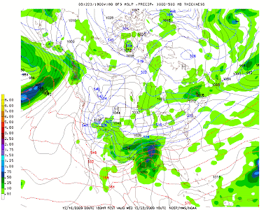
A strong storm system will finally move into East Texas today and with it, a threat for severe weather, including tornadoes. Out ahead of this system, very moist air from the Gulf of Mexico is surging north across the Lone Start State. We are even seeing a few breaks in the clouds this morning and that could lead to extra instability this afternoon.

Winds out ahead of this system this afternoon will increase out of the southeast around 18 mph gusting as high as 25 mph. This will help set the stage for the turning of wind with height that could lead to tornado development this afternoon and evening. The greatest risk of tornadoes appears to be from Tyler to Longview to Marshall and points south from 4PM through the overnight hours.

Scattered thunderstorms will develop ahead of the cold front during this time and it will be these scattered storms with the best chance to rotate. A strong line of storms will develop late tonight around the Metroplex and race east early tomorrow morning. Along this line we will see the possibility of strong winds and even an isolated tornado, although the tornado threat will not be as high as it will with any discreet storm this afternoon and evening.

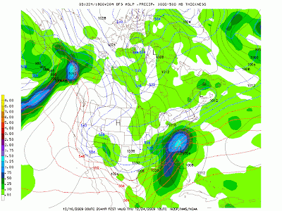
After this strong line of storms move through, very cold air will rush in tomorrow. Many of our forecast models are now indicating all the moisture may not be out of the area before the cold air moves in, especially north of I-20. What does this mean? It means there is a chance areas north of I-20 could see a few snow flurries.

The light blue around the I-20 and I-30 corridors is light snow that could eb falling tomorrow afternoon.

It all depends on the exact track of the upper low pressure system tomorrow. If this system moves farther south, the chance of snow could move into the Tyler and Longview areas however, no accumulation is anticipated at this time. Right now it does appear there could be a light accumulation north of I-30 and if you are planning travel into Oklahoma, several inches of snow could accumulate tomorrow.

Monday, December 21, 2009

Severe Storms Wednesday

A very strong storm system will develop on the Leeward side of the Rocky Mountains tomorrow afternoon. This storm system will draw in very moist air from the Gulf of Mexico and collide with a strong cold front across East Texas on Wednesday afternoon. The greatest likelihood of severe weather appears to be late Wednesday Afternoon through early Thursday morning for all of East Texas with the greatest threat east of a line from Sulphur Springs to Tyler to Lufkin. All types of severe weather are possible with this system including hail up to nickel size, gusty winds to 80 mph, and isolated tornadoes.


For anyone planning on traveling around Christmas, Wednesday will not be the best of travel days. If you are planning a flight to the Midwest, this same storm system will cause blizzard conditions in some areas.

Thunderstorms will begin to develop late tomorrow as mid level instability increases tomorrow afternoon. These thunderstorms will be elevated, forming above the boundary layer. Thanks to increasing steep mid level lapse rates and shear in the mid levels of the atmosphere, a few of these storms tomorrow could produce small hail but the overall threat of severe weather is very low.

On Wednesday enough low level moisture will be across the area to allow for surfaced base thunderstorm development. With the low level winds increasing around a developing area of low pressure across North Texas, there will be enough turning of the wind with height to give much of East Texas a threat of tornadoes.

The image above is taken from the 12Z run of the NAM forecast model on BUFKIT. There are a couple of things that show the possibility of tornadic supercells developing Wednesday afternoon and night. First is the hodograph, the graph in the upper left corner. This shows the wind speed and direction as you increase in height through the atmosphere. This is showing a classic large clockwise turn, or veering, of the wind with height, along with an increase in speed. This is very favorable for the lower levels of the atmosphere to spin.

Next we see the actual skew-t diagram, on the right. You notice the solid yellow line to the right of the solid red line. This is showing the amount of convective available potential energy, or CAPE, available for thunderstorm updrafts. Now the amount of CAPE is not all that great, only around 500 J/kg. But this is more than enough when you combine the shear and forcing associated with this upcoming storm system. So we will see thunderstorms developing in the boundary layer with rotating updrafts. All this means we will have to be on the watch for tornadoes Wednesday afternoon and evening as storms begin to develop.

As we head into Thursday morning the overall trend of these storms will be to form a squall line and race east. As this happens the overall severe weather threat will become more of a strong wind event than hail or tornadoes however, we will still have a chance at seeing an isolated tornado along the squall line.

Friday, December 18, 2009

Strong Storm Could Hit Just Before Christmas

The week of Christmas looks very interesting around East Texas to say the least. A very strong Lee Side low pressure system looks to develop Tuesday afternoon in the Colorado High Plains and move east northeast into the Midwest Christmas Eve. Out ahead of this storm system warm moist air from the Gulf of Mexico will surge northwest into the circulation of this strong low pressure. Because of this surface dewpoints in East Texas could easily reach the low 60s setting the stage for a possible severe weather event early Wednesday.
Surface Dewpoints

Right now it appears there will be plenty of instability in the lowest level of the atmosphere to produce scattered thunderstorms. The Lifted Index, or the difference between the lifted parcel temperature and the parcel’s surrounding temperatures, is negative across most of East Texas Wednesday morning.

Lifted Index

Also, the amount of bulk shear needed for supercell development will be more than enough, on the order of 50 to 70 knots.


Finally, the amount of surface based CAPE is enough to get the air rising from the surface leading to thunderstorm development. Now the amount of CAPE is nothing compared to what we might find during the spring severe weather months. However, when you take the normalized CAPE, or the amount of CAPE and divide it by the distance between the level of free convection and equilibrium level, you get a level conducive for strong updraft strength.

CAPE

Bottom Line, it looks as though the atmosphere is setting up for a round of low topped supercells Wednesday from East Texas through much of the lower Mississippi Valley with the potential for gusty winds, large hail, and even a few tornadoes.

Now for what everyone wants to know, will it snow for Christmas? Well, if I were a betting man I would bet against it however, the chances of snow are not at zero. That means there is hope for all you snow lovers of a few flurries flying on Christmas morning but no accumulation would occur. So what could lead to the possibility for snow flurries? The answer is a mid level disturbance, or shortwave, that sometimes produces surprise snow events in winter, especially across the south. (December 2004 Texas Gulf Coast)

On Christmas Eve a fast moving disturbance will drop out of Canada and race towards the southeast. Behind this disturbance will be a reinforcing shot of colder air for Christmas day. As this system drops south, clouds and flurries will form in the Northern Plains.


This disturbance will continue to move overnight Christmas Eve into Christmas Morning. As it moves into the Southern Plains, moisture will be very limited but it still appears there could be a few flurries as this system moves in.


By 6AM Christmas morning this system is forecast to be moving through the Metroplex. The big question will be moisture. Right now it appears there will not be enough moisture to produce snow flurries across East Texas. However, we will also be located in the left exit region of a strong jet streak that will aid in lift. If there is a little more moisture available than forecast, we could see a few flurries on Christmas day. I do want to stress that the odds of this occurring are very slim. Right now my official forecast for Christmas is partly cloudy and cold with highs around 40 and lows in the 20s. Snow lovers, keep believing……maybe Santa will bring a surprise.

Thursday, December 17, 2009

Gulf Low will turn into a Major Winter Storm!

This morning an area of low pressure was beginning to develop of the Coast of Brownsville, TX producing clouds and rain across a good bit of the Texas Gulf Coast. At the same time, cold air is spilling into the eastern United States. As this low strengthens and moves northeast, a major snowstorm is set for the Mid Atlantic and Appalachians.


Right now it appears our area of low pressure off the Texas Coast will explode into a very strong low pressure near the Outer Banks of North Carolina Saturday morning. This will cause near blizzard conditions from parts of North Carolina through the Piedmont of Virginia. Widespread snowfall amounts of over 6” can be expected in these areas with isolated amounts over one foot possible. The snowfall forecast from the 12Z NAM today shows a wide area of over 18” from the mountain of North Carolina to Central Virginia.

Wednesday, December 16, 2009

A Sneak Peek at the Christmas Forecast

White Christmas In Victoria, TX 2004
Every year around this time most everyone I meet and talk with ask me one question. Will we have a white Christmas? Unfortunately for all the snow lovers here in East Texas, snowfall is a rare occurrence, even more so on Christmas Day. Judging strictly on climatology data, the odds of seeing a white Christmas here this year are very slim, less than 20%. So what will happen this year?

I want to stress that what you are reading is not a forecast but is a trend on what we might expect this Christmas. Right now it appears a cold front will sweep through East Texas on Wednesday the 23rd. The air mass behind this front will be of arctic origin so we can expect cold temperatures Christmas Eve and Christmas Day. As this front moves through, showers can be expected out ahead of this front on Wednesday. Now for the interesting aspect to this trend. The latest long range forecast models are developing an area of low pressure along this front. The current placement of this low pressure Wednesday would give parts of the Gulf Coast region a chance of severe weather.

Low Pressure Near Lufkin
As this low intensifies and moves northeast, cold air with moisture would wrap around giving much of East Texas a chance of snow flurries or light snow showers. Temperatures would be very cold behind this front so any snow that falls would have a chance of accumulating. The window of opportunity for snowfall would last through early Christmas Eve Morning.

Wrap Around Snow Showers
For Christmas day, very cold air would be in place with morning low temperatures in the teens and highs struggling to reach the 30s. For those planning to travel to the Northeast, an all out blizzard could be expected with this system.

Strong Low off the Northeast Coast

Again, what you have just read is not my official Christmas Forecast. Right now my official forecast would call for dry, cold conditions with lows in the 20s and highs in the 40s. But it is always fun to look at all the possibilities of what “could” happen around Christmas.

This trend will more than likely change many times between now and Christmas. Keep checking back as I will post updates on what you might expect this Christmas weather wise.

Tuesday, December 8, 2009

Strong Storm Pounds U.S.


A massive storm system is plaguing the United States this week causing everything from severe weather and tornadoes along the Gulf Coast to blizzard conditions in the Great Plains. A strong area of low pressure is developing on the lee side of the Rockies and will produce a large swath of snow from southern California to the Great Lakes. Many areas will receive of 12” of snow across the Plains.

Temperatures this morning range greatly across the country from -34°F (wind chill -52°F) in Havre, MT to 82°F in Miami, FL.


A second area of low pressure is developing along a northward moving warm front along the Gulf Coast. It is this area of low pressure that has the possibility to produce severe weather across southeast Texas through most of Louisiana into Central and southern Mississippi. South of the warm front the atmosphere is conducive for the development of severe thunderstorms that could produce gusty winds and isolated tornadoes, mainly across Louisiana. To the north of this warm front in East Texas and Northern Louisiana, there could be a few strong to severe storms producing hail and high winds. The tornado threat in these areas is very low due to the cooler stable air near the surface.


This massive storm system will leave very few areas of the country untouched. By Thursday the area of low pressure will be over southeast Canada produce a very strong northwest flow across the Great Lake and Northeast. This will provide very windy conditions, cold temperatures, and the possibility of lake effect snows.


In the wake of this low pressure a strong area of high pressure over the Ohio Valley could provide the necessary cold air for an icy situation across parts of the southern plains by Friday. Right now the return of moisture will be in question but, the forecast position of the area of high pressure is enough to spark my interest.

Friday, December 4, 2009

Snow on the way to East Texas


Light snow continues to develop across Central Texas this morning and will push into East Texas late this morning into the early afternoon hours. Snow should begin east of the Trinity River around 10:00 AM and spread east from there throughout the afternoon. How far north will the snow reach? At this time it still appears the heaviest snow will remain south of the Tyler Longview area. Areas from Palestine to Center south could see up to an inch of snow with up to two inches of snow possible south of Lufkin. We could see a light dusting of snow as far north as Tyler and Longview. The exact track of this system is still a bit unknown but the heaviest snow will likely fall to the southeast of most of East Texas.

Thursday, December 3, 2009

Freezing temperatures tonight followed by a chance of snow Friday


Many areas of East Texas saw their first freeze this morning with some areas dropping into the upper 20s and lower 30s. Mostly sunny skies but cold temperatures will continue today with high temperatures only reaching the upper 40s.

We are currently monitoring an upper level disturbance across the Panhandle this morning producing light snow near Amarillo. This disturbance will move southeast across Texas overnight tonight and tomorrow bringing a chance of light snow or snow flurries to the southern half of East Texas tomorrow afternoon. There is a chance the snow could start off as light rain showers but with most of the upper atmosphere well below freezing and drier air located near the surface, evaporational cooling will rapidly change any rain over to snow. Right now it appears the snow will be too light for any major accumulation however, we could see a light dusting from a Palestine to Bullard to Carthage line south.

As this disturbance moves towards the Gulf of Mexico, an area of low pressure will begin to develop off the coast bringing another chance of snow to our southeastern counties. It does appear this low could cause significant accumulations of snow north west of its track. If the path of this low changes it could drastically change our snow forecast for East Texas. Right now the low appears to be too far east keeping the accumulating snowfall south and east of East Texas with the big winner being southwest Louisiana, where some computer models paint 4 to 6 inches of snow. Winter storm watches have been posted for the extreme southern counties of East Texas where some computer models indicate 2 inches of snow could fall.

The overall trend of this developing system is to continue pushing the moisture farther south and east making the chance of snow in East Texas less. The two images below indicate snowfall accumulation.


The image above is from the GFS forecast model's total snow accumulation for Friday's event. Areas in Pink are up to an inch of snow with the light blue being over 2 inches. This model indicates 3 inches or more of snow in the yellow area stretching from Center through Lufkin and totaling nearly 5 inches near Crocket. I think this model has a better handle on the area of snowfall but has too much accumulation.


The image above shows total forecast snowfall from the NAM forecast model. Notice the area of heavy snow, 6 inches plus, is well off to our southeast and produces a light dusting across East Texas with a bull's eye of 2 inches near Jasper. I think this model has a great grasp on the amount and area of snowfall however, i expect the area of a light dusting to be a little farther northwest, but not by much. We will continue to monitor this developing winter weather situation but for all the snow lovers out there, we might have to wait until the next storm system. The winter is still young.

Tuesday, December 1, 2009

Snow Possible for Parts of East Texas This Week

An upper level low pressure system brought a good deal of snow to parts of West Texas this week. This upper level low will cause widespread rain to develop this evening across East Texas and usher in some much colder air tomorrow, which could set the stage for a winter weather event Friday. Right now it looks as though a weak disturbance will move through East Texas Friday morning bringing a chance of snow flurries to the area. As this disturbance moves out into the Gulf of Mexico, an area of low pressure will develop and spread precipitation back across East Texas, especially across the southern half of the region. If this were to happen with cold air already in place, a significant winter storm could develop. As with any winter weather potential across East Texas, a lot could change between now and then. If this developing low pressure forms farther east in the Gulf, East Texas would get little or no precipitation. If this low develops farther west there is a good chance East Texas would just have a cold rain event. Stay tuned to your East Texas News Leader for the latest on this developing situation. I will continue to update the situation and more details become available.