As we head through the end of September, temperatures this afternoon will heat up once again. In a summer that just doesn’t want to end, it looks as though the century mark could be reached again in Tyler for the 82nd time this year. Now let’s put that number in perspective. Over the past ten years combined Tyler has reached 100 degrees 83 times. Over the past 30 years Tyler usually sees 100 degrees 7 times. The good news is the latest recorded 100 temperature occurred in Longview on October 3rd 1953. We are rapidly approaching that date so the end should be near, but this year nothing would surprise me.
Now relief is on the way as a strong cold front heads through the Plains States this afternoon. Out ahead of this front the air mass if very dry so clouds and showers will be hard to come by. Another problem today is out ahead of these fast moving fronts, the air is forced to compress. When this happens the air mass warms and with a lack of clouds, many areas should approach if not surpass 100 degrees this afternoon. But once the front moves through, it will feel like fall.
Temperatures in the northern Plains this morning were in the 30s and 40s with the coldest location I could find being Cut Bank, MT with 26 degrees. Now we will not see temperatures this cold but as this air mass moves south, we have a noticeable difference in our morning and afternoon temperatures. Many areas Sunday morning could be in the upper 40s and only warm into the upper 70s to near 80 degrees during the afternoon. The only thing that would make this forecast better would be the chance of rain which appears absent for the next few days.
So will today be the last time we see temperatures approach 100 degrees this year? There are signs the overall weather pattern is about to change starting next week. The ridge of high pressure that has kept us dry and hot looks to be replaced by a significant trough of low pressure. If this occurs then our rain chances will increase towards the second weekend of October which in turn would keep temperatures lower. This pattern looks to hang around through the middle of October which according to the record books is too late for 100 degree temperatures. But as I stated earlier, this year nothing would surprise me.

Thursday, September 29, 2011
Tuesday, September 6, 2011
Why is it so smokey?
I have been getting lots of questions on fires this morning because of the extreme amount of smoke in the area. Many people are worried if there is a fire near them and after the past couple of days, who can blame them? East Texas awoke to a tremendous amount of smoke this morning even though there was not an increase in fires. So how did this happen?
As the sun sets in a cool air mass, the earth cools rapidly causing ground temperatures to be much cooler than temperatures just above the surface. This is known as a temperature inversion. Basically the near ground atmosphere separates from the remainder of the atmosphere. We call this atmospheric decoupling. This also allows for the surface winds to diminish greatly. With the temperature at the surface much cooler than the temperature 500 or so feet above the surface, the smoke becomes trapped in the lowest layer of the atmosphere. As the smoke rises, it hits the temperature inversion and can go no higher so it spreads out across the entire area.
When we look at the sounding data for Tyler, or the temperature profile, the red line shows the air temperature as you go up in the atmosphere. Notice at 7AM this morning there was a strong inversion were the temperature decreases rapidly in the lowest 500 feet of elevation. By noon you can see the inversion in the lowest 500 feet is now gone and this allows for the smoke to mix out.
  Now there is another temperature inversion around 6000 feet in the atmosphere so the smoke can’t completely clear out but at least it will be a little easier to breath. Depending on what happens with the fires today, we could see a repeat performance of the smoke tomorrow morning.
As the sun sets in a cool air mass, the earth cools rapidly causing ground temperatures to be much cooler than temperatures just above the surface. This is known as a temperature inversion. Basically the near ground atmosphere separates from the remainder of the atmosphere. We call this atmospheric decoupling. This also allows for the surface winds to diminish greatly. With the temperature at the surface much cooler than the temperature 500 or so feet above the surface, the smoke becomes trapped in the lowest layer of the atmosphere. As the smoke rises, it hits the temperature inversion and can go no higher so it spreads out across the entire area.
When we look at the sounding data for Tyler, or the temperature profile, the red line shows the air temperature as you go up in the atmosphere. Notice at 7AM this morning there was a strong inversion were the temperature decreases rapidly in the lowest 500 feet of elevation.
 By noon you can see the inversion in the lowest 500 feet is now gone and this allows for the smoke to mix out.
 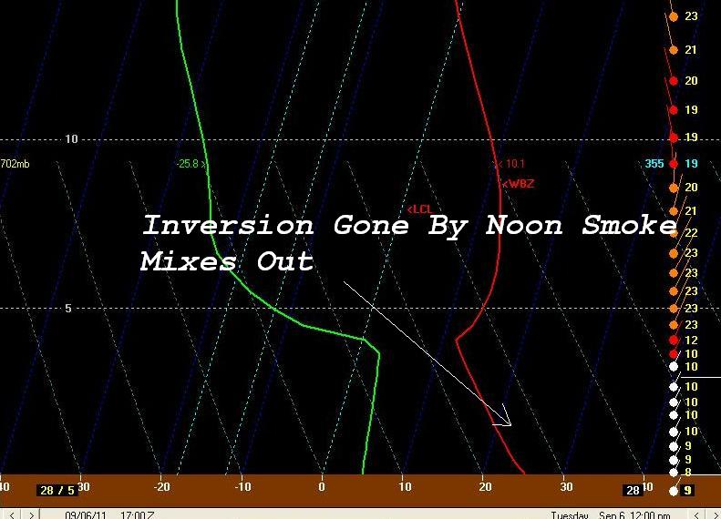 Now there is another temperature inversion around 6000 feet in the atmosphere so the smoke can’t completely clear out but at least it will be a little easier to breath. Depending on what happens with the fires today, we could see a repeat performance of the smoke tomorrow morning.
Subscribe to:
Posts (Atom)