Friday, May 14, 2010

It’s taking a while but, much needed rain is on the way


The cold front we have been advertising for days has stalled out to our west this morning. We are still anticipating this front to move into the area overnight tonight increasing the chance of rain for all of East Texas. This afternoon we will see a few scattered showers and storms develop thanks to day time temperatures reaching the middle to upper 80s. These storms will be few and far between so unfortunately, most areas will remain dry.

It is tonight that our front will begin to sag south into East Texas and with it, our rain chances increase. It looks as though we will see off and on thunderstorms throughout the weekend so keep the rain gear handy. As you can see from the forecast rainfall across the area, most of East Texas is forecast to have at least 1.5” of rain, the purple colors on the map.

A disturbance will move through the area Sunday night and push the cold front off to our east. There is a chance that as this disturbance moves through Sunday night, very heavy rain could occur. A few of our forecast guidance suggest some areas could see over 3” of rain. We will have to monitor this very closely. Due to the lack of rain, heavy rain will run off increasing the threat for flash flooding. Again this is not set in stone and a lot could change between now and then. Stay with your East Texas News Leader for the latest.

Thursday, May 13, 2010

Much Needed Rain On The Way

Over the past few weeks much of East Texas has fallen further behind in average rainfall with much of the area now 6 to 8 inches below normal. This rainfall deficit has dried out the soil from fall and winter rains to produce dry vegetation. This also has been allowing for our temperatures to be well above normal the past few days with highs reaching the lower to middle 90s across East Texas.

Well all this is about to change this weekend. Now we are not expecting to knock out the rainfall deficit but in a few areas, a major dent in the deficit will occur. This morning we are tracking a cold front out to our west. Strong thunderstorms producing very heavy rain and hail are developing to our west late this morning and will be heading towards our area later today.

Now for most of East Texas today looks dry. We will see a few isolated storms develop during the peak daytime heating hours, especially over our western counties. The cold front will move into and stall out across our area during the day Friday. As this happens, showers and storms will develop. The heaviest concentration of rain will be north of I-20 where the greatest amount of moisture and lift will be available. But areas across our southern counties could even see a few thunderstorms develop Friday afternoon thanks to greater daytime heating and instability.

Overall it looks as though areas north of I-20 could receive 1 to 2 inches of rain this weekend with greatest amounts near the Sulphur Springs and Mt. Pleasant areas. As the front continues to sag south, a greater chance of thunderstorms will occur across the Nacogdoches Lufkin and Hemphill areas on Saturday producing up to or slightly over 1 inch of rain. So we will not make up our rainfall deficit this weekend but take a big step towards getting closer to normal.

As for the threat of severe weather with this system, the overall threat looks fairly weak. There is a slight chance one or two storms could become marginally severe producing hail and gusty winds but the atmosphere right now appears it will not be conducive for severe storm development.

Friday, May 7, 2010

A Severe Storm Possible Today

Another warm humid day is in store for East Texas this Friday with temperatures once again approaching the 90 degree mark. However, today we have a cold front moving into the area and this front has the chance to produce a couple of storms later today. The storms that do develop along this front will only be isolated but could pack quite a punch. Right now it appears a few storms could produce large hail around the size of quarters and gusty winds up to 60 mph. Due to the isolated nature of these storms, the Storm Prediction Center has removed most of East Texas from the slight risk of severe weather today. But we will continue to monitor this developing situation. The greatest chance of seeing a severe storm this afternoon would be from a Center Alto Crockett line and points south.

After the cold front moves through this evening, a very pleasant day is on tap for our Saturday. We will see a few clouds however; northeast winds will bring very dry air into the area. Afternoon temperatures in the middle to upper 70s will make for a very pleasant afternoon.

It still looks as though the front will move back to the north on Mother’s Day. We are not anticipating wide spread rain or storms with this warm front but a few areas could see rain. Right now it appears the Lufkin Nacogdoches areas could see scattered showers during the morning hours with the activity moving north throughout the day. Scattered showers will be possible along I-20 by midday and by I-30 during the afternoon hours. Again, this does not appear to be a wide spread rain event and most areas will remain dry. To keep up with the latest throughout the weekend be sure to check out our interactive radar to see if it will rain where you live.

Happy Mother’s Day to all the Moms out there!

Tuesday, April 27, 2010

Yesterday's Central Texas Chase

A few lightning shots from a severe storm over Temple Texas Yesterday afternoon.

Wednesday, April 21, 2010

Severe Storms appear likely Friday

As we move closer to the weekend it is appearing more likely that a severe weather event will occur across Parts of East Texas Friday afternoon and evening. The Storm Prediction Center currently has a large area of the Plains and Midwest under a slight risk of severe weather Friday, including all of East Texas. It looks as though parts of East Texas could be upgraded to at least a moderate risk of severe weather, mainly north of I-20.


Severe weather will begin to break out this afternoon across the Texas Panhandle as a strong storm system begins to take shape. This storm system will move to our north on Friday dragging a dryline and a cold front into East Texas. Right now the atmosphere is forecast to be conducive for very large hail, larger than golf balls, gusty winds, and isolated tornadoes. The forecast hodograph for Friday afternoon shows a tremendous turning of the wind with height. The large clockwise turning is favorable for tornadoes however, in the lowest 1km of the atmosphere; the turning of winds is not as great. So I do believe we will see an isolated tornado or two but right now it does not look as though we are looking at a major tornado outbreak. I will add many times with an atmospheric set up like we will have Friday, storms will move slightly faster and more to the right than forecast. This will greatly increase the low level clockwise curvature of the winds increasing the tornado threat.


Right now it appears the greatest threat of severe weather will be large hail. By looking at the forecast sounding for Tyler Friday afternoon, a lot of ingredients are coming together to produce large hail. There is a large amount of positive buoyant energy, CAPE, which will allow for robust updraft strength. There is also a cap in place, an area where the temperature increases above the earth’s surface holding back initial thunderstorm development. This will allow daytime heating to reach its peak before explosive thunderstorm development occurs. Also the sounding shows a large amount of the buoyant energy is in the hail growth region, between -10°C and -30°C. This tells me we will see some very large hail. When you combine this with strong wind shear, golfball size hail seems very likely with the possibility of baseball size hail occurring in a few storms.

Overall this does appear to be a significant severe weather threat. Both the hodographs and soundings are very similar to the event which occurred April 9th last year. If you don’t remember, this event produced 5 tornadoes in East Texas and 87 tornadoes across the Southern Plains and Southeast.

Tuesday, April 20, 2010

Severe Weather Possible Friday


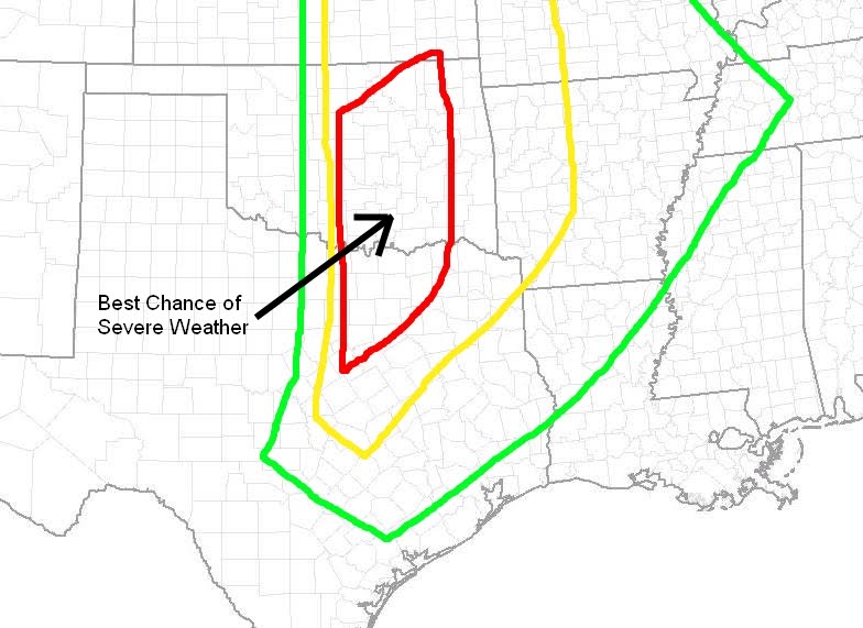
So far the severe weather season of 2010, other than January 20th, has been very quiet. A continued intrusion of cold air over the late winter and early spring weeks have suppressed the Gulf moisture needed for strong storm development well to the south. This is about to change, at least for the end of this week. Currently we are watching a strong upper air disturbance along the Pacific Northwest coast which will move to the four corners region by Wednesday afternoon. As this system moves out of the Rockies in to the Southern Plains, a dryline will develop across west Texas and move its way towards our area. Right now it appears we will see some severe storms develop Thursday Afternoon from the Eastern Texas Panhandle south towards West Texas. These storms will move east and lose some of their strength Thursday night into Friday morning. This dryline will still be out to our west Friday afternoon giving East Texas plenty of time to warm into the lower 80s. This will set the stage for severe storms to develop out to our West late Friday afternoon and move east into East Texas Friday evening and overnight. At this time it appears there will be plenty of instability and wind shear to keep these storms at severe levels through the overnight hours. The atmosphere will be conducive for very large hail, strong gusty winds, and isolated tornadoes. Remember we are still four days away from this developing storm system and a lot could change between now and then. Severe weather outbreaks require many ingredients to come together at once. Any difference in timing could cause these storms to be weaker or stronger. Below is an outlook for severe weather on Friday. This is NOT an official forecast. The Storm Prediction Center does have most of East Texas outlooked for a 30% or greater chance of severe weather Friday. The outlook below is based on the 0Z model runs and can and probably will change between now and Friday. For those used to SPC outlooks, do NOT use the colors on this outlook to determine slight, moderate , and high risk areas. I have enhanced an area in red where I feel the greatest risk of severe weather will take place on Friday. I do believe we will see a moderate risk of severe weather issued for Friday.

Thursday, April 15, 2010

Tornado hits India

You may have heard on the news that a powerful cyclone hit Northeast India Tuesday Night killing over 100 people. In actuality what appears to have hit this area of the world was a tornado. This area of the world is no stranger to severe weather and tornadoes, many times called cyclones in this part of the world. Based on archived satellite images it does appear a broken line of strong thunderstorms, possibly supercells, developed as moist southerly winds off the Bay of Bengal were forced vertically along the front range of the Himalayan Mountains. I do not know for sure if these were indeed true supercells as the nearest Doppler radar site is over 400 km away and I could not find any archived data. Based on the latest information from the Regional Meteorological Center in Alipore a tornado did indeed move across Northeast India from the northeast corner of the Bihar State into West Bengal. Top winds were estimated around 125 km/hr or78 mph which would be an EF-0 tornado in the U.S. Lack of warning and poor construction can be attributed to the loss of life, over 120 at last count, many of which lived in mud shacks.

Below is a satellite loop I made from archived images.

Friday, April 9, 2010

Remembering One Year Ago Today


One year ago today a tornado outbreak began across East Texas and proceeded to spread across much of the Mid South and Southeast. Before the outbreak ended, 87 tornadoes touched down causing 5 deaths and injuring 146 people.


The day began with a moderate risk of severe weather across parts of Arkansas and a slight risk across most of East Texas and Louisiana. Across East Texas, the threat was very conditional, meaning if the storms were to develop, they would rapidly become severe but there was still a chance no storms would form at all.

Well, the storms did develop and ended up producing large hail and 5 tornadoes across East Texas.
Tornado Tracks In Red.
Fortunately for us, very few injuries were reported and no fatalities occurred. It was a different story across other areas of the south where one tornado in Arkansas killed 3 people.

One of the most interesting aspects of this event was in Southwest Arkansas where an anti-cyclonic tornado struck near Centerpoint. This tornado was rated an EF-2 and had a damage path of up to a half mile, very large and strong for an anti-cyclonic tornado.
Now anti-cyclonic tornadoes are not unheard of, but what is interesting about this one was the unusually large size. The storm that produced this tornado began as a part of the supercell which produced three tornadoes in Cass County. This cell split and the left mover remained as strong as the right mover. The left mover showed anti-cyclonic circulation for around 30 minutes before the half mile wide tornado touched down.

You can read more about this event from the Nation Weather Service in Shreveport here.

Friday, April 2, 2010

Strong Gusty Winds, Hail, and Tornadoes Possible This Evening

Strong to severe storms are likely to develop across East Texas this afternoon and evening bringing the threat of large hail, strong gusty winds, and even an isolated tornado or two. A dryline, a front separating moist tropical air from dry continental air, is slowly moving east as of late this morning. Based on radar trends the dryline should be moving into our western counties from Greenville down to Palestine around 4PM. Out ahead of this line a few showers and storms have developed on the tail end of an upper air disturbance moving to our north. These showers should diminish in intensity over the next couple of hours. An area of sinking air on the right front side of a jet streak is currently moving into the area.

This could allow for addition heating this afternoon. By late this afternoon, East Texas will be in what we call the right rear our right entrance region of this jet streak. This will aid in lifting to increase the storms’ strength this evening. It still looks as though the greatest threat will be strong gusty winds and hail however, any additional surface heating will increase our chance of tornadoes. Current visible satellite image shows clearing skies over much of East Texas. This could allow temperatures to reach near 80 degrees again today and this will increase the instability needed for severe thunderstorm growth.


It still appears the best timing for these storms will be from 3PM in our western counties, 6PM in the Tyler area and 10 PM in our Eastern counties.

Thursday, April 1, 2010

Severe Storms Possible Tomorrow Evening

Spring time warmth has finally moved into the area and although many of us are glad to see it, it does have a downside. The warmer temperatures we have seen this week will aid in the development of strong to severe storms tomorrow afternoon west of Dallas. These storms will form into a squall line late tomorrow and race through East Texas during the evening hours. Right now it appears the main threat from these storms will be large hail and strong gusty winds. The atmosphere will be conducive for tornadoes tomorrow as well however, the tornado threat looks to be small. If we have any isolated storms develop out ahead of the squall line, these storms would have a chance to produce tornadoes so we will have to monitor this situation closely.

The best timing as of right now for severe weather is for the storms to enter our western counties late tomorrow afternoon or evening. The line of storms will probably make their way into the Tyler Longview areas around 9PM, and then exit East Texas around 1AM Saturday.

Sunday, March 28, 2010

Left Moving SC Supercell


Most tornadic supercells have a counter clockwise circulation, or cyclonic circulation in the northern hemisphere. The cell I am showing you has NOT had a tornado reported with it much less a tornado warning but has shown an anti-cyclonic or clockwise circulation for sometime. This storm is what we cause a left mover. Many times the left moving part of a splitting supercell weakens and dies out. However, in some cases the left moving cell can become very strong. In the image above you can see the air moving towards and away from the GSP radar site shows a clockwise circulation. We had a similar situation last year in Arkansas were a left moving super cell produced an EF2 tornado. The image below shows what appears to a backwards hook echo.

Friday, March 26, 2010

"Cold Core" Set up in Oklahoma for Saturday?

As with most of the storm systems to move through the Southern Plains this year, tomorrow’s event will be lacking a major necessity, moisture. Wednesday’s storm system has scoured most of the low level moisture and dewpoints will be hard pressed to reach the middle 50s across East Texas. However, the system moving into the Southern Plains is very dynamic and I look for at least a broken squall line to develop ahead of a dryline East of I-35 tomorrow afternoon. The threat for tornadoes is very small however, we could see an isolated strong wind gust.
There is an area under the 500 mb low near the Oklahoma Kansas state line that has my interest for the possibility of tornadoes tomorrow afternoon. Models are not forecasting very high dewpoints with this system however, with the very cold mid level temperatures associated with the upper level low, low level instability will be increasing throughout the afternoon.

The WRF-NMM 5km is showing a good deal of Instability tomorrow afternoon as the upper low moves over the Kansas Oklahoma state line. LIs by 1PM are approaching -6 near Tonkawa, OK as the image below shows.


The next image continues to show good instability in this area along with another area of increased instability near Ada, OK with LIs approaching -8 by 4PM.


The next big question for tomorrow's event is will there be enough moisture. The image below shows dewpoints approaching 50 degrees by 1PM tomorrow.


By 4PM dewpoints are progged to be in the lower 50s under the 500 mb low, image below. Both the GFS and NAM are a little farther east with the low and have dewpoints about 5 degrees cooler.


So will we see any severe weather with this set up? If the WRF verifies, I believe we will see a few low topped supercells develop near the triple point and an isolated tornado or two seems possible. I would also look for a broken line of storms to develop along the dryline east of I-35 down into East Texas. We could see some hail and gusty winds with these storms. The next three images show storms developing around 1PM through 6PM.


I am going to wait until I get a good look at all the 12Z model data but it looks at this time Tonkawa, OK will be a good starting point. I will have to leave around 6AM to get there an hour or so before initiation. We shall see what happens.

Wednesday, March 24, 2010

Strong storms possible tonight across East Texas


A strong area of low pressure is developing to our northwest today and will drag a cold from through the area early tomorrow morning. As this front moves through showers and storms will develop along and ahead of the boundary. The atmosphere is favorable for strong gusty winds and hail as this line moves through. There is also a slight chance an isolated tornado could develop with these storms however, the over threat of tornadoes appears to be fairly low with this system. If more moisture than is forecast surges north ahead of this system, the threat for tornadoes could increase early tomorrow morning as the wind field in the atmosphere becomes more favorable for tornado development. We will be monitoring this developing situation throughout the evening and overnight tonight. Behind this system partly cloudy skies will move into East Texas tomorrow with cooler temperatures.

We will see another chance of storms late Saturday but at this time moisture seems to be a limiting factor in severe weather. We could see an isolated strong storm late Saturday but widespread severe weather is not anticipated at this time.

Sunday, March 21, 2010

One More Snowman!


Well, my little girl Halen was able to make another snowman today. I am kind of hoping this is the last one for the year, I am sure it is.

Heavy Snow For Parts of East Texas


Heavy snow is beginning to fall across parts of East Texas this first FULL day of Spring. Reports of over 8” of snow have been received from areas near Dallas and this heavy band is now moving through Van Zandt and Henderson Counties. The good news is the sun’s energy is helping to melt most of the snow today however, in very heavy bands snow will accumulate on grassy surfaces and bridges and overpasses. Near blizzard conditions have been reported with visibilities less than a ¼ mile in heavy snow with wind up to 35 mph. If you have to be out and about this afternoon, use caution.

Friday, March 19, 2010

Strong Storms Followed by Cold, Maybe Snow, To Usher in Spring

A very strong upper air disturbance is swinging through the Desert Southwest this morning and promises to bring big changes to the area this weekend.

Out ahead of this upper air disturbance a strong surface low pressure will develop late this afternoon across West Texas. This low will travel northeast overnight bringing a cold front to the area by Saturday morning. It looks as though this front will have enough forcing to produce a line of thunderstorms, some of which could be strong. The best chances for seeing severe weather at this time appear to be well off to our south and east however; a few of these storms could produce strong gusty winds and small hail.


The big story is what will occur behind the front. The front looks to move through East Texas around noon tomorrow, close to the Vernal Equinox marking the start of Spring at 12:32 PM tomorrow. As the front moves to our east, another, stronger area of low pressure will develop along the front producing very gusty winds and bringing much colder air into the area. This low will not be in a hurry by any means. This will keep the chance of rain and thunderstorms in the area throughout a good bit of the day. Temperatures by 6 PM tomorrow will be approaching the upper 30s north of I-20 with wind chill values in the upper 20s! It is at this time that the upper level disturbance associated with very cold temperatures aloft, will move across the Red River Valley. As this occurs, any rain left in the area along and north of I-20 could mix or change to snow. That’s right snow! Right now it does not look as though we would see any accumulation but areas to our north could see a very significant snowfall.


Parts of Oklahoma could get as much as 15 inches of snow if this low moves as slow as some computer forecast models are showing. If the upper air disturbance moves farther south, then areas north of I-20 could see some accumulation so we will have to watch this very closely. This is a very similar set up to the Easter snow of 2007. Again, the overall chance of snow in East Texas is small, but it is there. One thing is for sure. Temperatures will be much colder than normal through the beginning of the next work week. Many areas in East Texas will see freezing Temperatures both Sunday and Monday morning. This blast of Old Man Winter will not last long as by Tuesday we will once again see highs reaching the 70s.

Thursday, March 11, 2010

A Look at Yesterday's Chase


Yesterday's chase was very successfully as we were able to capture great structure photos and end the day with a great lightning display. Above is the image of the storm that became severe in Cherokee County during its initial growth.


The photo above is the rotating updraft base from a severe cell in southwestern Anderson County. This base was fairly high and was undercut by the dryline. This caused the storm to quickly lose its intensity. I do like the fact you can see a little precipitation shaft behind the base. This was the storms rain/hail wrapping around the mesocyclone.


The image above is from the supercell base which became the prolific hail producer from Lindale to Gilmer and points north and east. The lowering is from the storm's inflow or where the warm moist air is ingested into the updraft. This eventually formed a nice wall cloud but due to roads and trees, a great image is not available.

The next three shots is how we ended the day. We decided to take a break from chasing and head to Love's Lookout north of Jacksonville. Here we had a great view of severe storms over Rusk, Cherokee, and Nacogdoches Counties. They performed well for us as we were able to get numerous lightning shots.


Wednesday, March 10, 2010

Monday, March 8, 2010

Heavy Rain Possible Today, Severe Storms Wednesday

A potent storm system spinning over the Four Corners region today will help showers and thunderstorms develop across East Texas this afternoon and evening. The wind profile in the atmosphere is very conducive for severe weather today however, with a lack of surface heating and low dewpoints, severe weather is not expected today.

Very Strong Turning of Wind with Height!

We could see a strong storm or two as we do see a little elevated instability this evening. The main threat would be small hail and a few gusty winds.

Sounding shows weak instability aloft


Today’s system will drive a dryline/cold front through the area early tomorrow. With clearing skies and gusty west southwesterly winds, high temperatures will reach the middle 70s tomorrow afternoon.

Another potent storm system is currently diving down the Pacific coast this morning and will swing across the Southern Plains Wednesday. This system will have much warmer air to work with along with higher amounts of moisture. At this time it appears there is a fairly good chance of seeing severe storms Wednesday including isolated tornadoes. The Storm Prediction Center currently has the Eastern two thirds of East Texas under a slight risk of severe storms on Wednesday. If the trends continue to look the way they do I look for at least our Eastern Counties to have an upgrade to a moderate risk for severe storms. Right now it looks as though scattered supercells will develop east of I-35 around noon Wednesday and move east. These storms will have the potential to produce large hail, damaging winds, and tornadoes. As strong forcing catches up to these storms I look for a squall line of severe storms to form late Wednesday afternoon increasing the threat for damaging winds across our Eastern Counties. As with all severe weather events, a lot could change between now and Wednesday but is does appear there is a chance of a significant severe weather event Wednesday afternoon and evening.

Strong Surface Instability

Decent Low Level Shear/Not as Strong as Today

Sunday, March 7, 2010

Fun with Photos

Tried out my new 50mm f/1.8 II lens today. Took about 30 photos of my daughters toy truck and put it to time lapse.

Friday, March 5, 2010

Spring Time Pattern to Bring Storms Next Week

A strong storm system is moving across the Southwest United States this afternoon and will set the stage for rain and thunderstorms across East Texas Monday. The big question this time of the year is will we see any severe weather with this system. Right now it looks as though there is a Chance of a few strong thunderstorms but a lack of moisture may keep things from getting too out of hand. Yesterdays mid range forecast data showed there is a chance of severe storms across East Texas Monday. As we get closer to the event, forecast models are still suppressing the moisture necessary for severe surface based convection, the storms that can produce tornadoes. The image below show the forecast dewpoint temperatures Monday evening as the storms move through. The brighter green indicated the 50 degree dewpoint. We would normally need to see dewpoints in the low 60s to start introducing a tornado threat with this type of set up. I still feel models are underestimating the dewpoint temperatures but I have my doubts on low 60 dewpoints making it up to I-20.


However, there will be plenty of forcing to help with in elevated convection so I do think we will see a few strong, possible severe storms with hail being the main threat. The image below shows vorticity at 500mb. We can see a negative tilted vort max moving through the area. this will aid in rising air parcels which could lead to thunderstorms.


We can also see that by the image below East Texas will be in the left front quadrant of a jet streak. This too will aid in lift helping to form thunderstorms.


Monday's event is starting to look more like a heavy rain event than a major severe weather threat. Again, if higher dewpoints move into the area, the threat of severe weather will increase. The available shear will help make any thunderstorm become supercellular and if this storm is able to ingest surface based instability, there is enough low level turning with height of the winds to where tornadoes would be a concern.

Another storm system will be moving towards East Texas quickly on the heels of Monday's system. There are some differences in the mid range forecast models so I will point out the "worst case" scenario from the GFS. Notice in the image below the dewpoints are much higher than with Monday's system. They do approach the 60 degree mark increasing the threat for tornadoes.


The image below shows the forecast sounding for Wednesday afternoon. You can see that there is over 1000 J/kg of CAPE, plenty of buoyancy for thunderstorm development this time of the year. Another concern is the location of the LCL, lifted condensation level. The is normally where we would find the cloud base in thunderstorm development. The LCL is less than 800 feel above ground level, very low and very conducive for tornadoes.


Now that we can see we will have rising air, what will be occurring in that column of rising air. By looking at the hodograph below you can clearly see a large clockwise turning of the wind with height. This is very conducive to tornado development.


Now the difference between the LCL and LFC, level of free convection, is around 3000 feet. But if you look at the images below you can see there is other areas of forcing to help rise that air from the LCL to the LFC.


Both the 500mb vorticity and jet stream look very similar to Monday's event. So we will have added lift to help generate storms.


The amount of bulk shear Wednesday is forecast to be over 50 knots as well which will promote supercellular structure. The possible difference between Monday and Wednesday is on Wednesday storms should be routed in the surface layer meaning there is a threat of tornadoes. I will also state that the European forecast model keeps the area of low pressure along the Gulf Coast keeping surface based storms well to our south basically eliminating the tornado threat. We will have to monitor these developing systems very closely over the weekend.

Wednesday, March 3, 2010

Pattern Change Promises Warmer Weather

The winter months have been very active thanks to El Nino so far this year. We saw very cold temperatures during the first two weeks of January. A few places even saw temperatures drop into the single digits. Later in the month we saw a more spring like pattern with a significant tornado outbreak on the 20th.

For February we saw a very active sub-tropical jet remain to our south along with the polar jet bringing very cold air to the region. This lead to a couple of major snow events in East Texas including up to a foot of snow near Canton on the 11th through the 12th. Another interesting fact for February was there were no tornadoes in the U.S. It looks as though the last time the U.S. went tornado free in February was 1947. Also the last month without a tornado in the U.S. was January 2003, which later became very active severe weather season. (For more information on this click here)

***UPDATE***
There is now an official report of one tornado that touched down near Taft, CA. Here is the report from the National Weather Service:

PRELIMINARY LOCAL STORM REPORT NATIONAL WEATHER SERVICE SAN JOAQUIN VALLEY CA 323 PM PST TUE MAR 02 2010 ..TIME... ...EVENT... ...CITY LOCATION... ...LAT.LON... ..DATE... ....MAG.... ..COUNTY LOCATION..ST.. ...SOURCE.... ..REMARKS.. 0445 PM TORNADO 15 NE TAFT 35.30N 119.27W 02/27/2010 F0 KERN CA TRAINED SPOTTER TRAINED SPOTTER REPORTED A WEAK TORNADO THAT LASTED ABOUT 3 MINUTES ABOUT 15 MILES NORTHEAST OF TAFT. NO DAMAGE WAS REPORTED. RATED EF0.

Well, it looks as though now the pattern will shift once again. A deep trough looks to develop over the western U.S. and this will help send much warmer weather into the Southern Plains and Southeast. It looks as though the polar jet will retreat to the north with an active sub tropical continuing to our south. This will allow warmer weather to filter in to the area with the threat of thunderstorms developing.

Sunday Evening Upper Air Chart

The first large scale severe weather event could unfold across the Southern Plains Sunday through Monday. Right now it appears a strong surface low will develop in eastern Colorado Sunday bringing warm moist air into the area. How much moisture makes it in to the Plains will be the determining factor. Mid range forecast models have been flip flopping on the amount of instability and buoyancy available for thunderstorm development. The amount of wind shear needed for supercell development should not be an issue. So if enough moisture makes it into the Southern Plains we will more than likely see severe thunderstorms develop Sunday afternoon through Monday. Large low level clockwise hodographs would indicate there would be a threat for tornadoes with surfaced based convection.


So after a slow start to what normally would be an active severe weather season thanks to El Nino could be about to ramp up. If the storm track in February would have been a couple of hundred miles farther north, we would have seen at least threes sever weather events instead of snow here in East Texas. Well, the storm track is moving north again.