

So far the severe weather season of 2010, other than January 20th, has been very quiet. A continued intrusion of cold air over the late winter and early spring weeks have suppressed the Gulf moisture needed for strong storm development well to the south. This is about to change, at least for the end of this week. Currently we are watching a strong upper air disturbance along the Pacific Northwest coast which will move to the four corners region by Wednesday afternoon. As this system moves out of the Rockies in to the Southern Plains, a dryline will develop across west Texas and move its way towards our area. Right now it appears we will see some severe storms develop Thursday Afternoon from the Eastern Texas Panhandle south towards West Texas. These storms will move east and lose some of their strength Thursday night into Friday morning. This dryline will still be out to our west Friday afternoon giving East Texas plenty of time to warm into the lower 80s.
 This will set the stage for severe storms to develop out to our West late Friday afternoon and move east into East Texas Friday evening and overnight. At this time it appears there will be plenty of instability and wind shear to keep these storms at severe levels through the overnight hours. The atmosphere will be conducive for very large hail, strong gusty winds, and isolated tornadoes. Remember we are still four days away from this developing storm system and a lot could change between now and then. Severe weather outbreaks require many ingredients to come together at once. Any difference in timing could cause these storms to be weaker or stronger. Below is an outlook for severe weather on Friday. This is NOT an official forecast. The Storm Prediction Center does have most of East Texas outlooked for a 30% or greater chance of severe weather Friday. The outlook below is based on the 0Z model runs and can and probably will change between now and Friday. For those used to SPC outlooks, do NOT use the colors on this outlook to determine slight, moderate , and high risk areas. I have enhanced an area in red where I feel the greatest risk of severe weather will take place on Friday. I do believe we will see a moderate risk of severe weather issued for Friday.
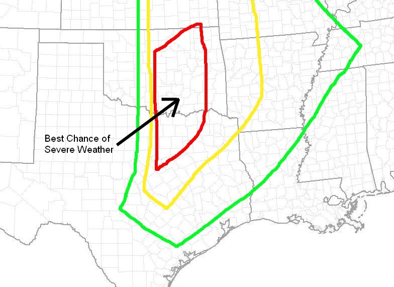
No comments:
Post a Comment