Monday, August 31, 2009

Erika Could Form Today.


The tropical Atlantic looks to become active again as Erika will probably begin to form today. Satellite shows a fairly well organized system moving into an area favorable for development. Our mid range tropical computer models vary with the strength on this system. It does appear we will at least see a strong tropical storm if not a hurricane by the Thursday or Friday. A weakness in between two areas of high pressure, one in the central Atlantic and the other over the U.S., could steer this system into the Atlantic. There is a chance this system could move south of this weakness and this could steer this system into the Gulf of Mexico. Stay tuned for the latest information.

Friday, August 28, 2009

Remembering Katrina


Four Years ago today the Gulf Coast was changed forever and the city of New Orleans was about to go under water. Scientists’ worst fear, a category 5 hurricane, was about to make landfall on the City of New Orleans. The catastrophe that followed was unimaginable just 24 hours earlier to most but, the Nation Weather Service in New Orleans put out a couple of statements that really made you feel the severity of what was about to happen. The first statement is a special weather statement issued by the national weather service on the morning before Katrina made landfall. The second is the afternoon forecast discussion hours before Katrina made landfall. Just Chilling!

URGENT - WEATHER MESSAGE
NATIONAL WEATHER SERVICE NEW ORLEANS LA
1011 A.M. CDT SUN AUG 28 2005
...DEVASTATING DAMAGE EXPECTED...
.HURRICANE KATRINA...A MOST POWERFUL HURRICANE WITH UNPRECEDENTED STRENGTH...RIVALING THE INTENSITY OF HURRICANE CAMILLE OF 1969.
MOST OF THE AREA WILL BE UNINHABITABLE FOR WEEKS...PERHAPS LONGER. AT LEAST ONE HALF OF WELL CONSTRUCTED HOMES WILL HAVE ROOF AND WALL FAILURE. ALL GABLED ROOFS WILL FAIL...LEAVING THOSE HOMES SEVERELY DAMAGED OR DESTROYED.
THE MAJORITY OF INDUSTRIAL BUILDINGS WILL BECOME NON FUNCTIONAL. PARTIAL TO COMPLETE WALL AND ROOF FAILURE IS EXPECTED. ALL WOOD FRAMED LOW RISING APARTMENT BUILDINGS WILL BE DESTROYED. CONCRETE BLOCK LOW RISE APARTMENTS WILL SUSTAIN MAJOR DAMAGE...INCLUDING SOME WALL AND ROOF FAILURE.
HIGH RISE OFFICE AND APARTMENT BUILDINGS WILL SWAY DANGEROUSLY...A FEW TO THE POINT OF TOTAL COLLAPSE. ALL WINDOWS WILL BLOW OUT.
AIRBORNE DEBRIS WILL BE WIDESPREAD...AND MAY INCLUDE HEAVY ITEMS SUCH AS HOUSEHOLD APPLIANCES AND EVEN LIGHT VEHICLES. SPORT UTILITY VEHICLES AND LIGHT TRUCKS WILL BE MOVED. THE BLOWN DEBRIS WILL CREATE ADDITIONAL DESTRUCTION. PERSONS...PETS...AND LIVESTOCK EXPOSED TO THE WINDS WILL FACE CERTAIN DEATH IF STRUCK.
POWER OUTAGES WILL LAST FOR WEEKS...AS MOST POWER POLES WILL BE DOWN AND TRANSFORMERS DESTROYED. WATER SHORTAGES WILL MAKE HUMAN SUFFERING INCREDIBLE BY MODERN STANDARDS.
THE VAST MAJORITY OF NATIVE TREES WILL BE SNAPPED OR UPROOTED. ONLY THE HEARTIEST WILL REMAIN STANDING...BUT BE TOTALLY DEFOLIATED. FEW CROPS WILL REMAIN. LIVESTOCK LEFT EXPOSED TO THE WINDS WILL BE KILLED.
AN INLAND HURRICANE WIND WARNING IS ISSUED WHEN SUSTAINED WINDS NEAR HURRICANE FORCE...OR FREQUENT GUSTS AT OR ABOVE HURRICANE FORCE...ARE CERTAIN WITHIN THE NEXT 12 TO 24 HOURS.
ONCE TROPICAL STORM AND HURRICANE FORCE WINDS ONSET...DO NOT VENTURE OUTSIDE!
AREA FORECAST DISCUSSION...UPDATED
NATIONAL WEATHER SERVICE NEW ORLEANS LA
452 PM CDT SUN AUG 28 2005


.UPDATE...TO ADD TORNADO WATCH #752.

.DISCUSSION...
SOUTHEAST LOUISIANA SEEMS POISED FOR A DATE WITH DESTINY AS CATEGORY 5 HURRICANE KATRINA CONTINUES TO KEEP A BEAD ON BARATARIA BAY AND THE GREATER NEW ORLEANS AREA. THE GFS MODEL CONTINUES TO BE SUPERIOR IN ITS HANDLING OF THE SYSTEM INASMUCH AS TO BASE THE CONVENTIONAL FORECAST PARAMETERS WITH GOOD INTEGRITY AND IN AGREEMENT WITH NHC ADVISORIES.

NEEDLESS TO SAY...THE WORST CAN BE ANTICIPATED AND URGENCY IS BEING STRESSED IN ALL PRODUCTS AS A WORST CASE HURRICANE SCENARIO FOR THIS VERY FRAGILE AND VULNERABLE STRETCH OF U.S. COASTLINE. THE EYE IS EMERGING ON THE KLIX LONG RANGE LOOP AND BANDS ARE EXTENDING TO LAKE PONTCHARTRAIN AT THIS TIME. THINGS WILL BE DETIORATING STEADILY FROM THIS POINT FORWARD FOR THE NEXT 24 HOURS.

WILL MAINTAIN ALL WARNINGS AS ALREADY POSTED AS WELL AS THE FLASH FLOOD WATCH. STORM PREDICTION CENTER HAS ADVISED THAT THE FIRST TORNADO WATCH OF THE EVENT WILL LIKELY BE ISSUED FOR THE REGION EARLY THIS EVENING...PROBABLY RIGHT AFTER SUNSET.

MOST ATTENTION WITH THIS PACKAGE WAS DAY 1-2 WITH LITTLE IF ANY CHANGES MADE BEYOND DAY 3. GOOD LUCK AND GODSPEED TO ALL IN THE PATH OF THIS STORM.

There has been much discussion on whose fault and why we saw so many deaths from Katrina. Without getting political let me say I hope we have all learned a valuable lesson and when a catastrophic storm heads towards the coast again, residents get out.

Thursday, August 27, 2009

Wednesday's Pop Up Storms.

Wednesday afternoon and evening saw some very strong to severe storms develop across parts of East Texas. I decided to head to the lookout off highway 69 north of Jacksonville in Cherokee County to watch a developing storm move west. The visibility was good from the high elevation looking east at the developing storm. The storm which later became severe formed on top of two intersecting outflow boundaries from earlier morning storms. This allowed for some rotation in the lower levels of the storm producing the funnel cloud you see in the photo below.
I took around 300 photos of this storm alone trying to catch a daytime lightning strike, not one. Trust me, there was plenty of lightning, I just need to work on my reflexes. This storm eventually moved into Anderson County and was showing signs of a huge hail core. Thankfully not too much in the way of large hail was reported, doesn’t mean it did not fall somewhere.
I drove north to the Bullard First Baptist Church and tried my luck at a few lightning shots. Once again I was unsuccessful but I did catch an amazing shot. The photo below is of a developing storm west of the church as the sun sets behind it. Notice the crepuscular rays streaming across the top of the storm, beautiful.


Once the sun set the atmosphere released the last bit of instability with a dramatic lightning display over southwestern Smith County and eastern Henderson County. This display of lightning was one of the best I have seen in years. Of course with my luck, I did not have a good view of the storm from my house so I had to get in the car and drive to where I had good visibility. Unfortunately for me, the best lightning shot I have seen from last night was not from my camera. Tim Ogrodnik of Altra Federal Credit Union was nice enough to send me some photos he took of the storm. In a word, amazing!
Thanks to Tim Ogrodnik!

By the time I made it to my destination the storm was beginning to die down. I was able to catch a few nice shots but nothing near the quality of Tim. I hope you enjoyed the photos. Hoping for a little lightning photography tonight, we shall see.


Wednesday, August 26, 2009

Tropical Storm Danny


Tropical Storm Danny has formed in the Atlantic Ocean this morning. Hurricane hunter aircraft report top winds with Danny are 45 mph. Danny is forecast to become a hurricane and eventually turn to the north and northeast. The question is when will Danny make the turn? Most tropical forecast models turn Danny out to sea in plenty of time and miss the United States East Coast. However, a couple of our short range and long range forecast models show Danny becoming a major hurricane hitting the Outer Banks of North Carolina and then riding up the East Coast. Stay tuned for the latest.

Monday, August 24, 2009

Hurricane Andrew 17 years ago today.


The Last Category 5 hurricane to hit the United Stated occurred 17 years ago today as Hurricane Andrew slammed into the south Florida Coast with sustained winds of 165 mph and wind gusts over 200 mph at times. The destruction this storm caused was in a word, incredible. Most of a hurricane’s damage is caused by its storm surge, water that piles up on the right side of the storm’s motion thanks to low pressure and strong winds. Hurricane Andrew caused incredible damage due to its strong wind field. The damage path across south Florida looked more like a 30 mile wide EF-3 tornado than a hurricane. I witnessed the damage first hand as I was traveling through Homestead Florida on the way to the Florida Keys in Late August of 1992. The destruction was like nothing I had ever seen. Every building on Homestead Air Force Base sustained major damage. Every Building! It looked as though south Florida had been hit by a nuclear bomb. My heart sank as we drove through neighborhoods where houses were gone and replaced by large tents to house the homeless. With military helicopters flying everywhere and the National Guard on the ground, it definitely looked like a war zone.

Andrew started as a tropical wave off the coast of Africa on August 14th. By the 17th the tropical wave became a tropical storm and was given the name of Andrew. Over the next few days Andrew battled dry air and some wind shear but maintained its tropical storm status. By the 22nd of August, Andrew reached hurricane status and began to rapidly intensify over the next 24 hours.


On the morning of the 23rd Andrew became a strong category 4 hurricane with top winds of 155 mphn early a category 5 storm. As Andrew moved across the Bahamas, he weakened slightly with top winds of 150 mph, still a very strong category 4 hurricane. On the Early morning of the 24th, Andrew moved across the very warm waters of the Gulf Stream off the coast of South Florida. This set Andrew into a rapid intensification stage becoming a category 5 hurricane with top winds of 165 mph before hitting Elliott Key in Dade County Florida (now Miami-Dade County). As Andrew continued inland he continued to strengthen with the storm’s structure reaching its top strength near Homestead, FL, about 20 miles inland.

Andrew became the costliest natural disaster to hit the United States until 13 years later when Katrina would devastate the Gulf Coast. Damage estimates for Andrew were around $25 billion.

For the amount of destruction this storm caused the overall death toll was low, 23 in the United States (source NWS). The number of home destroyed by Andrew was 25,521and 101,241 homes were damaged (source NWS).


Friday, August 21, 2009

Friday Morning's Storms


Strong storms moved through East Texas this morning with heavy rain, gusty winds, small hail, and a tremendous lightning display. I was very upset I left my digital camera at home this morning but thanks to our Photog Philip Stauts, we have some video of the amazing light these storms put on this morning.


Thursday, August 20, 2009

Severe Weather Possible Tonight.


An early season cold front will move into East Texas tomorrow and out ahead of this front tonight, showers and storms will develop. A few of these storms tonight and early tomorrow morning could be severe with gusty winds and small hail being the main threat. The greatest risk of severe weather will be along and north of Interstate 20, closer to the upper level support needed for organized severe storms.
Late this morning the cold front was located just north of the red river with thunderstorms developing in eastern Oklahoma. This afternoon with daytime heating, the atmosphere will become moderately unstable. As the cold front moves into this environment it will force the warm moist air up causing showers and thunderstorms to develop. Winds in the mid levels of the atmosphere are set up to where strong straight line winds could become a problem as a line of storms develops. The mid levels of the atmosphere are not that cold this time of the year so very large hail is not a concern however, we could see a couple of reports of hail the size of quarters in the strongest of storms. As this line of storms moves south through the area Friday morning, the storms will move away from the greatest are of upper level energy causing the storms to weaken.
Behind this line of storms, much drier air will filter into the area. Some of our computer models hint at dewpoint temperatures in the low 50s by Sunday morning. If this holds true we could see morning lows drop into the upper 50s and low 60s Sunday morning in parts of East Texas but for now we are sticking with lows in the middle to upper 60s.

Wednesday, August 19, 2009

Beaumont Tornado

Life in the northwest corner of Beaumont, TX was interrupted Tuesday afternoon by an unexpected tornado that caught many off guard. The tornado that developed around 2:00pm Tuesday afternoon formed with no warning as the parent storm showed no signs of rotation. By analyzing radar data and looking at the storm environment, it appears a “landspout” tornado, much like a waterspout, formed rapidly under an intense thunderstorm updraft. A landspout, a term used to describe non-mesocyclone tornadoes, forms when an area of surface vorticity, or rotation, is stretched vertically when it encounters an updraft of a developing storm. Doppler Radar from Lake Charles, LA shows that on outflow boundary was stalled out across Jefferson County Texas and this would be the source for the surface vorticity.


This boundary was formed from a collapsing storm off to the northeast of Beaumont. This boundary moved southwest until it encountered strong enough winds to stop its forward progression. It was the interaction of northeasterly winds on the east side of the boundary and the southwesterly winds on the west side of the boundary that caused areas of surface rotation to form. As this rapidly developing updraft moved across this rotation it stretched it into the vertical causing the tornado to form. You can see from this radar loop how fast the storm which caused the tornado developed.


Next you can see the volumetric scan of the storm just north east of Beaumont. Watch the rapid development of dark red colors over the area where Kohl’s is located. This shows the storm had rapidly moving updrafts that were able to ingest the surface vorticity, rotation, and pull it upward causing the rotation to rapidly increase developing into the tornado.


Just a reminder to always be on the watch for the possibility of severe weather and even tornadoes under rapid thunderstorm development, especially near stalled boundaries.

Bill Now a Cat 4


Bill is now a strong Category 4 hurricane with top winds over 135 mph. This eyewall convection has weakened just a bit this morning however this can be expected as these stronger storms go through eyewall replacement cycles. This may cause fluctuations in Bill’s overall intensity but we still expect Bill to gradually increase in strength over the next 72 hours before Bill enters cooler waters. The good news for the United States is a strong trough of low pressure is still forecast to force Bill out over the Atlantic. Below is a current satellite image of Bill.

Saturday, August 15, 2009

Ana and Bill

Below is Tropical Storm Ana. This satellite will update when you hit refresh. Right now you can see that the main area of thunderstorms is east if Ana's circulation. As long as this continues Ana will have a hard time developing. Long range models differ on the placement of Ana early next week with some moving Ana out into the Atlantic and others sending her into the Gulf of Mexico. We will continue to monitor Ana closely over the next few days. An average position puts her over south Florida early next week.

Ana is No More

The satellite loop below is of Tropical Storm Bill. Long range computer models still hint at Bill being a major hurricane by Wednesday of next week with winds over 125 mph. Average position for Bill next week is moving towards the Florida Straight. To get an updated loop hit refresh with each new visit.


Java must be enabled for radar loops to display.


In Netscape:

Select: Edit -> Preferences -> Advanced

Check "Enable Java" and "Enable Javascript"


In Internet Explorer

Select: Tools -> Internet Options -> Security tab

Select the Internet zone and set the Security level for the zone to "Medium"


You may need to restart your browser after making these changes.


We will watch both systems closely but it appears Bill has a greater chance of becoming a serious threat to the US Mainland. Stay tuned for the latest information.

Friday, August 14, 2009

Three areas of Concern.


Well, our tropical depression was really worked over by dry air intrusion and strong wind shear Wednesday. Even though we saw a few storms develop yesterday near the center of circulation, the easterly shear was enough to downgrade the system to a tropical low. There is still a chance this system could redevelop but it will take some time. Most of our mid to long range tropical computer models keep this system weak and not a threat to the US Mainland but there are one or two outliers that develop this system back to a tropical storm. But even these models turn this system out into the Atlantic.
Disturbance number two looks very healthy and will more than likely be a tropical depression later today or early Saturday. Most of the mid to long range tropical computer models are locking in on this system and have been for days. It looks as though this system could be a hurricane that we will have to watch very closely by the middle of next week. The GFDL shows this system as a Major Hurricane with top winds of 115 mph by Wednesday morning entering the Windward Islands.


This model also shows a strong ridge of high pressure building west across the Atlantic and this would help steer this storm towards Southern Florida and possibly the Gulf of Mexico. Again we are a long way away from this timeframe and many variables can and will change so stay tuned for the latest.
Disturbance number three is interacting with an upper level low so right now tropical development would be very slow, if at all. This system should drift west around the outer edge of the strong Atlantic ridge of high pressure giving East Texas a good shoot of tropical moisture leading to afternoon and evening thunderstorms next week.

Thursday, August 13, 2009

Will Ana Ever Form?


Tropical Depression #2 is having a hard time developing into Ana but if it can get through today, I feel it will have a very good chance to develop into our first named storm of the year. The dry air on the northern fringe of our tropical system is no were near as strong as it was yesterday. Also, the ridge of high pressure in the central Atlantic is strengthening pushing our tropical system on a more westerly course rather than turning to the northwest. The southwesterly winds aloft have also relaxed so our tropical depression will be encountering less wind shear today than yesterday however, there still is fairly strong unidirectional shear from the stronger mid level easterly winds. Now the wind shear and dry air really ripped this system apart late yesterday but the latest visible satellite indicates new thunderstorms are forming near the center of circulation. If this trend continues, look for the tropical depression to strengthen once again and possible be named Ana by tomorrow morning.

Tuesday, August 11, 2009

Tropics Becoming Active


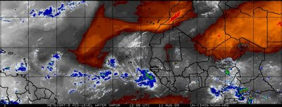
We finally have a tropical depression that appears to be on tract to become the first named tropical system of the year. It is fairly late in the tropical season not to have had a named tropical storm even though we are still a month away from the peak of the tropical season. On the tropical weather map we see a couple of tropical waves moving into the Lesser Antilles today, our tropical depression, and another tropical low that has just moved off the African Coast. Also noted on the weather map, a strong ridge of high pressure located across the northern Atlantic with a weak trough of low pressure located between two areas of high pressure. It is this weak trough that could pull TD#2(Ana?) to the north and keep it away from the mainland. A couple of mid range computer models are hinting this could happen while others are showing the high pressure ridge increasing keeping the tropical depression on a westerly course. It is interesting that most long range models are not picking up on TD#2(Ana?) becoming very strong but weakening the system as it moves west. This is more than likely because the dry air located on the southern fringe of the strong ridge of high pressure that the system could ingest. Red Color North Of TD#2=Dry Air Could Slow Development.
However, most long range models are picking up on the Tropical Low(TD#3) staying farther south of the dry air and becoming an intense tropical storm or weak hurricane as it heads towards the Lesser Antilles early next week. So we could see Ana form within the next 48 hours followed by a stronger system (Bill) next week.
'Bill' Early Next Week?
One thing is for sure, the tranquil tropical season so far is about to get a little more interesting over the next few days.

Late Evening Storm


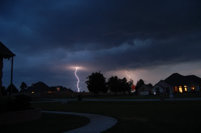
Around 9:30 last night a storm quickly pulsed up over the Lake Tyler area of southeastern Smith County. The storm did not last very long but was loud enough to wake me so I grabbed my camera and snapped a few shots. I was able to capture a couple of lightning bolts. The storm was over a few minutes before 10:00 PM so it was off to bed again.

Monday, August 10, 2009

Southeast Smith County Storm


A collection of stills put together to make a time lapse of the weak Southeastern Smith County Thundershower This Evening.

Ana? It is about time.......


We are watching the tropics closely as an area of low pressure could become our first tropical system of the year off the African Coast. Now this system is still a long way from affecting any area of the United States and would be at least a week away from entering the Gulf of Mexico if it does develop. We are seeing a strong ridge of high pressure over the central Atlantic and this would help steer the tropical system south and possibly move into the Gulf or Caribbean. Again it is a long way away but it is never too soon to start thinking of a “Plan of Action” if this system holds together and moves into the Gulf.
The 2009 Atlantic Hurricane Season has been very quiet so far this year but it only takes one storm to make a quiet tropical season turn into a destructive tropical season. This year’s hurricane season is very similar to the 1992 Atlantic Hurricane season. Like 2009, the 1992 hurricane season started of very quiet thanks in part to an El Nino weather pattern causing variations in the jet stream we normally do not see this time of the year. It is these variations in the mid and upper level winds that have sheared apart any tropical low before the system could strengthen to tropical storm or hurricane strength. On August 14th, 1992 a tropical low moved off the African coast and began to strengthen. As it moved west, it encountered very warm waters and light atmospheric winds allowing it to become a tropical depression and finally a named tropical storm. The name this storm was given was Andrew.

In case you don’t remember, Andrew became only the 3rd category 5 hurricane to strike the United States and was the costliest natural disaster to effect the United States until 2005 when Katrina hit the Gulf Coast.
The atmosphere over the northern Atlantic is very similar to the set up we saw in mid August 1992. A strong ridge of high pressure is dominating the central Atlantic Ocean and this will help keep the tropical system on a westward track, making a North American landfall more likely. Long range computer models currently track this system west and eventually turn the system to the north along the Eastern United States Coastline. It must be noted however we are still at least seven days away from this system being a threat to the Atlantic or Gulf Coasts of the United States. Many changes can and probably will occur before then so stay tuned for the latest information.