Tuesday, February 23, 2010

Winter Storm Warning/WInter Weather Advisory


A winter storm warning is in effect for our southern counties today and a winter weather advisory is in effect for the I-20 corridor. An upper level low pressure will move across the state today causing widespread precipitation to break out. This will likely start out as a rain snow sleet mixture this morning but quickly transition to all snow by the late morning hours. Heavy snow is likely in some areas of East Texas today especially south of the Tyler Longview area. The Image above is the forecast snowfall for East Texas through tonight. Notice the swath of 4 plus inches of snow expected from Palestine to Center. Up to two inches of snow can be expected along the I-20 corridor as well. For our snow lover along the I-30 corridor, we may see a dusting to as much as an inch but it looks as though the majority of the snow will miss our northern counties.

Monday, February 22, 2010

1st Storm Chase of 2010


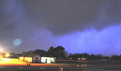
The first storm chase of the 2010 season ended up providing a little excitement even though our target area was off. Saturday 12Z model runs were pointing to two areas of possible severe thunderstorm development. One was over Louisiana where low clouds and fog would make storm visibility horrible, and the second area was over Central Texas as a dryline was progged to move from Dallas to Waco during peak afternoon heating. We decided to choose the second target based on visibility and an anticipated pooling of moisture out ahead of the dryline. So we decided to head to Corsicana giving us a good north south east and west option depending on where storms developed. Once there a quick look at the new SPC mesoanalysis page, which is amazing, showed instability building in the Fairfield are so we headed south to wait for storm initiation. Once there I found an abandoned house with some very spooky trees and I had to take a shot. You see that at the top of the page. We waited for about 30 minutes and noticed the dewpoint beginning to drop, dry line was mixing through the area. So I took a glance at the NWS in Fort Worth’s Convective Parameters page, which usually performs very well, and noticed the convective interest near Dallas was in the upper 80s, meaning storms were likely to initiate there within the hour. So we raced north.


As we were driving north we noticed storms firing in the Metroplex. The southern storm riding the boundary took on a mini supercellular form. Radar showed 67.5 dbz that never reached higher than 20,000’, as you can see from the volumetric scan.


The next image is the velocity data. The rotation on radar was fairly week but from our vantage point, you could see the updraft tower rotation fairly well.


The reflectivity image shows a small hook on the southwest side of the storm which persisted for about 30 minutes on radar. The view we had of the storm as we approached western Kaufman County was incredible. We were able to see a flanking line, a well defined wall cloud, a tilted updraft, and what appears to be a tornado. In the photo I have it labeled as a tornado look alike but after seeing fellow storm chaser Simon Brewer blog, you can easily see this was a funnel and it was not on the ground. He was much closer to the updraft than I was when my photo was taken.


The storms updraft was quickly undercut by cooler drier air as it moved closer to us. A new updraft began to form on the southeast side of the storm. The photo below is of that rotation updraft with a small funnel trying to develop. Smile Paul!


This updraft was undercut as well and lead to the demise of a very nice mini supercell and left a rainbow coming out of the back of the storm.


New storms were trying to form to our east near Canton but even these storms didn’t have much of a chance as the dry boundary raced east and undercut the storms' development. All in all, not a bad 1st chase day especially for as low of a severe risk we had in Central Texas.

Winter Storm Watch for parts of East Texas


A winter storm watch is in effect a good chunk of Texas including Anderson, Henderson, and Houston Counties in East Texas. An upper level low pressure associated with very cold air aloft will move across the state starting tonight. As this system moves in to East Texas, rain mixed with sleet and snow should start to fall by tomorrow morning. As the precipitation increases, surface temperatures will drop to near freezing by tomorrow afternoon causing snow to accumulate in some areas. Right now it appears the greatest chance of accumulating snowfall will be south of I-20 where some places could receive an inch or two. The greatest snowfall looks to occur from Palestine to Rusk and points south to a Crockett Lufkin line. Isolated amounts could be over 4 inches in these areas. Below is a snow fall accumulation map from the NAM forecast model. This model did very well predicting the East Texas snow 10 days ago 24 hours out so if it is right again, a few places could see as much as 6 inches of snow. It all depends on where the heaviest bands of snow develop which we really won't know until tomorrow, so this snowfall forecast could change.

Friday, February 19, 2010

Another Significant Snow on the Way?


This could go down as one of the snowiest winters on record if the solution mid and long range forecast data suggests comes true. Right now we know a strong cold front will move through Sunday bringing us a chance of thunderstorms, some of which could reach severe limits, followed by cooler air next week. For quite sometime now all indications were the air mass behind the front would not be all that cold but continue to give East Texas below normal temperatures. But all that is beginning to change over the past 12 hours. New forecast data suggest a much colder week is in store for East Texas and an area of low pressure will once again develop to our south in the strong subtropical jet.

So what does all this point to? The chance of another significant snow across East Texas. Now remember, what I am showing you is the forecast trend, not an official forecast. However, if this trend continue over the next day or two, look for snow to be put back in our forecast.


Above is the forecast sounding for Tyler at noon on Tuesday afternoon of next week. This sounding screams heavy wet snow, like we saw last week. The forecast sounding 6 hours before and 6 hours after look about the same. This would give us a prolonged period of heavy wet snow, again only if this scenario pans out. A few things that peek my interest looking at this sounding. First, the atmosphere is at saturation from the surface to 300mb, basically this time of the year the stratosphere. This would allow for very heavy precipitation to fall. Also you can see the temperature of the atmosphere remains below freezing except the last 300' or so near the surface, much like last week. This means the snow will be very wet. Finally there is some upper level instability in this sounding. This means there could be some lightning in the clouds giving us, yes, thundersnow.

Below is the forecast for the accumulation of snowfall up to 120 hours out, or Tuesday afternoon. You can see that through the Dallas area, another significant snowfall is shown with over 10" in a few places.


The next image shows the snowfall farther east into East Texas. Again this only goes out to 120 hours when the heaviest snow begins to fall. If you interpolate the data it looks as though another swath of 4"-6" is possible across the northern half of East Texas.


Again a lot can and probably will change between now and this event. However, long range forecast data performed very well on last weeks snow event, even under forecast the snow amounts. This is in no way is an offical forecast for the area but, if this trend continues parts of East Texas could get more snow making this the snowiest winter on record.

Tuesday, February 16, 2010

4th Greatest Snowfall in Longview Last Week

Thanks to the National Weather Service Fort Worth

Last week's snowfall across East Texas produced an amazing amount of snow across the area. Notice the snowfall map above that parts of East Texas saw a foot of snow near Canton and points west. We already looked at the way this storm stacks up historically in Tyler. So now let's look at this storm historically in Longview. It looks as though this snow will also go down as the 4th greatest snowfall in Longview as well. Longview kept much better records with no gaps of missing years of data. The top five snowfall events for Longview are as followed:

#1 Dec 21st, 1929 14"
#2 Dec 15-16th, 1983 8.5"
#3 Jan 13th, 1982 8.25"
#4 Feb 11-12th, 2010 7.0"
#5 Feb 1-2nd, 1985 6.0"

4th Greatest Snowfall in Tyler Last Week


Last week's snowfall across East Texas produced snowfall amounts many areas have not seen in over 20 years. So I thought I would dig through the record books to see how this snow compared to some of the greatest snowfalls in East Texas history. The official records for Tyler go back to 1883. However, there are a few holes in the data. The winter months are missing from 1883 through 1889. Also, the years 1906-1939and 1951-1954 are missing entirely. So my findings cannot be 100% accurate but from the data available, last week's snow will go down as the 3rd greatest snowfall off all time. Here is a list of the 5 greatest snowfalls in Tyler on record:

#1 Jan 14th, 1982 8.0"
#2 Jan 30th, 1949 7.5"
#3 Feb 11-12th, 2010 6.0"
#4 Jan 14th , 1944 6.0"
#5 Feb 1-2nd 1985 5.5"

Looking through the missing data years at other East Teas locations I found on December 21st, 1929 a strong snow storm covered most of East Texas with 10 to 16 inches of snow including 14 inches in Longview. So I have a hard time believing that Tyler did not receive at least 10 inches of snow during this event which would make last week's snow the 4th greatest of all time. There of course were other snow events during the missing data years but by judging what occurred around Tyler, I feel pretty confident these events did not eclipse the 6 inch mark. This snow event will also go down as the greatest amount of snow for the month of February in Tyler.

Friday, February 12, 2010

The Biggest Snow in Nearly 20 Years


Widespread snowfall covered East Texas this morning. Amounts were mostly around 6 inches but a few areas received as much as 10 inches, Lindale for instance. I will be putting together a photo log of this event and create a snowfall map so everyone can see what an amazing event this really was.

Wednesday, February 10, 2010

Winter Storm Watch Issued


The image above from the National Weather Service Shreveport


A winter storm watch is in effect for our central and eastern counties tomorrow afternoon through Friday morning. Widespread snowfall amount of two plus inches can be expected. A few heavy bands of snow could develop along and south of I-20 producing local amounts between 3 and 5 inches, possibly as high as 6 inches in localized areas. Most of the snow will accumulate on elevated and grassy surfaces but during periods of heavy snow, slushy roads will develop. Overnight Thursday night we will see some snow develop on roadways.

Snow Looking More Likely.


I must admit this winter weather scenario for Thursday and Thursday night has been one if not the most challenging forecast I have had to deal with. Right now it looks as though snow will fall across most of East Texas tomorrow and could accumulated in some areas, maybe as much as two inches along the I-20 corridor east of Tyler. But it could be worse.

Our official forecast for snowfall accumulations as of 9:00AM Wednesday is for around an inch of snow to accumulate on grassy surfaces along a line from Athens to Bullard to Carthage and points north. Along the I-20 corridor East of Tyler there could be as much as 2 inches. But as I write this new forecast data is coming into the office trending a bigger snow event, like was advertised on Monday.

What makes this forecast so difficult is the fact the temperature I the atmosphere straddles the freezing line from the surface to about 7000 feet. Usually we see in a situation like this, a warm nose of air around 5000 feet that melts the snow on the way to the surface. With this system we do not see that however, there are places where the temperature around 5000 feet does go above freezing. In these areas snow would melt and only rain would reach the ground. The problem is locating where this will occur and even if it does, heavy precipitation could cool this warm nose of air back to the freezing point and then we are back to snow.


Now if this warm nose of air never makes it up to the I-20 corridor, which some forecast models are showing now, nothing but snow will fall from Athens to Carthage north and this would cause a large increase in snow accumulation. In fact, looking at the latest snowfall accumulation chart, a swath of 4 to 5 inches in being shown across the I-20 corridor. I look for winter storm watches to be issued later today for parts of East Texas after looking at the latest data. Again, a lot could happen between now and the event but it is looking more like snow will occur.

Monday, February 8, 2010

Rain Today, Snow Possible Later This Week

A strong storm system will develop today across central Texas bringing a good chance of showers and thunderstorms today. Some of the storms could produce small hail thanks to the cold mid level temperatures today. The farther south you move today, the better chance of seeing a strong storm or two. A warm front will move into the extreme southern counties of East Texas today, from Crockett to Lufkin. Along and south of this line I can’t rule out an isolated severe storm however, most of the severe weather should remain well to our south.

Later this afternoon and into this evening, a strong cold front will usher in much colder air. Right now it appears most of the moisture will be out of the area as the cold air moves in however, there is a chance a few snow flurries could develop tonight mainly from I-20 north. This will set the stage for a possible winter storm starting as early as Wednesday night through Friday morning.

An area of low pressure will begin to develop across southwest Texas Wednesday afternoon. Right now it appears this low will track to the east remaining well to the south of East Texas. This will give most of East Texas a chance at seeing some snow develop. As moisture moves over the cold dome of air at the surface, light rain and sleet should develop across the area towards Late Wednesday night. This will help cool the atmospheric column allowing snow to reach the surface by Thursday morning. Right now forecast models are showing the potential of a prolonged light to moderate snow event. The meteogram below shows a detailed forecast with timeline of what could happen if the low pressure remains on its forecast track (remember, the timeline starts to the right and then moves left).


You can clearly see there is nearly a 36 hour period of snow (forecast is for Tyler). This could lead to a significant snowfall for parts of East Texas if this verifies. The latest accumulated snowfall forecast puts a swath of three to five inches of snow across parts of East Texas (See Below).


As with all winter weather forecast here in East Texas, a lot could and probably will change before this system develops. If the low pressure tracks farther north, then most of East Texas will see rain. A little farther south and much of East Texas will see snow. I will say this however. This system has been advertised for many days now and continues to show a significant threat of winter weather across parts of East Texas. Usually as we approach a winter weather event, forecast models trend farther north and warmer with systems. This system has trended colder and farther south. Stay tuned as we fine tune the forecast as more details become available.

Wednesday, February 3, 2010

Old Man Winter on his way Back!


Next week it looks as though old man winter will make another visit to East Texas, and much of the eastern half of the Nation. There will also be two opportunities for winter weather next week as a couple of storm systems move through with cold air in place.

A strong arctic high pressure is building across the Canadian Prairies and will begin to move south this weekend. This will send a strong cold front racing towards East Texas either late Sunday or Monday giving us a chance of rain as this front moves through. An area of low pressure is forecast to develop somewhere along this front. If this low forms to our west, it will move south of East Texas along the Gulf coast as the cold air rushes in. If, and this is a big if, this happens, East Texas would be under the gun for a major snowstorm. Timing is always an issue here when it comes to winter forecasting. Usually the moisture is gone by the time the cold air moves in however, it is interesting that forecast models are beginning to show the cold air reaching East Texas before the moisture moves out. The image below is a meteogram from the 06Z GFS forecast model (the time line goes from right to left, opposite from what you would normally read).

The meteogram shows a strong front moving through dropping temperatures around Midnight Monday followed by a 12 hour period of snow, some of which would be heavy. Now let me stress this is just a trend. I am not forecasting a big snow storm early next week, right now I am just mentioning rain followed by cold weather but, it is very interesting to see these latest forecast model trends.

The next opportunity of winter weather would be late next week as the arctic high move east and an over running precipitation event takes shape. Warmer air from the Gulf could be forced over the cold dome of air at the surface causing clouds and precipitation to develop. With surface temperatures at or below normal and temperatures above freeing aloft, sleet and freezing rain would be the main threats with this event. The following two images are forecast maps for Friday evening. Notice the temperatures are in the upper 20s and low 30s with around 0.25” precipitation falling. This could produce a significant amount if ice accumulation.


Again this is a long way out. What I have covered are forecast trends, not an official forecast. I am very confident that a significant cold air mass will move into East Texas next week. If this air mass while moisture is in place, we will see a winter event. But in most cases, the moisture is gone when the cold air moves in making significant winter weather events very rare across East Texas. Stay tuned, more to come.

Tuesday, February 2, 2010

One of the Coldest Arctic Outbreaks 59 Years Ago Today


On February 1st, 1951, A strong arctic high pressure moved south out of the Canadian Prairies and by the morning of the second, set up over East Texas. This produced some of the coldest temperatures in history including the coldest temperature ever in Lufkin. Along this front precipitation broke out and a large band of snow developed from Central Texas through the northern Gulf States. Dozens of record lows were set across the country the morning of the 2nd including a few of the following:

Lufkin, TX -2°F
Tyler, TX 2°F
Longveiw, TX 3°F
Texarkana, TX -3°F
Shreveport, LA 2°F
Lake Charles, LA 13°F
Beaumont, TX 13°F
College Station, TX 5°F
Memphis, TN -11°F
Tupelo, MS -1°F
Jonesboro, AR -3°F
Greenville, MS -2°F
Tuscaloosa, AL 5°F
Huntsville, AL 3°F
Muscle Shoals, AL 1°F
Nashville, TN -13°F

Friday, January 29, 2010

Parts of East Texas Could See Ice.


As we were hinting to yesterday, forecast models are having a hard time handling this shallow arctic air mass moving into East Texas. Temperatures already are around five degrees colder than these models were indicating and if this trend continues, a few areas north of I-20 could see some freezing rain later this afternoon.

As an area of low pressure moves to our south, northeast winds are bringing much colder air into the area from the Ozarks this morning. This is allowing middle 30s to set a foundation across the northeastern corner of East Texas. Rain will continue to develop to are southwest throughout the day as temperatures continue to drop towards the freezing point. Ground temperatures across East Texas are well above freezing so we are not anticipating a significant icing event. However, temperatures in a few areas will drop down to the freezing pint before the rain moves out, so ice could begin to accumulate on elevated surfaces such as trees and power lines as well as bridges and over passes later today. The best chances of this occurring will be from a Sulphur Springs to Pittsburg to Jefferson and points north and east.


We are still watching an upper level disturbance that will move towards the Red River Valley this evening. Moisture wrapping around the back edge of this system could bring a few snow flurries or freezing drizzle to the northern half of East Texas. Right now we are not anticipating much in the way of travel problems however; please use caution while driving over bridges and overpasses this evening and overnight tonight. Stay tuned to your East Texas News Leader for the latest.

Thursday, January 28, 2010

Line of Severe Storms Continues


Line of storms continues. Good news is the storms are moving faster east than the low level jet. It is the low level jet that is fueling these storms with the lack of instability. Once these storms move off the jet axis, they should begin to weaken. This should happen just as these storms approach the Tyler area. Western counties could still see a severe wind gust or two. i plan on meeting these storms as they enter Kaufman CO. Watch for pictures later.

Wind Damage Reported With Storms


Wind damage reported in Cross Plains at the Hwy 36 motel. Roof is damaged and power lines down. Damage caused by a possible tornado. If this line holds together it will be in our western counties around 5:30PM. Doppler radar shows sings of rotation all along this line with winds up to 60 mph all along this line.

Look at the Temperature Difference


Temperatures range from 19 in Amarillo and Dalhart to 77 in Del Rio at 1PM. Severe storms are forming in central TX with a tornado warning out for Eastland CO. Strong gusty winds could occur across East Texas if this line holds together. Flash flood warning are also in effect with this line but as the line speeds up, flooding concerns will decrease.

On the cold side of the storm. I-40 around Amarillo is closed. Up to 6" of snow has fallen in the Panhandle with drifts up to 2 feet. Visibilities in heavy snow are under 100 yards. This is going to be a historic storm across parts of the Southern Plains. If you plan to travel across Oklahoma or the Texas Panhandle, cancel don't. Conditions are life threatening in these areas.

1"-2" of Rain for East Texas, Major Ice Storm North.


A strong winter storm is developing across northwest Texas today and will spread a major ice and snow storm to our north. For East Texas this system will bring a round of very heavy rain with one to two inches likely for most of the area with a few localized spots receiving up to three inches. We are not anticipating any flooding problems at this time however, the will be ponding of water on roadways and some areas could see localized flooding during the heaviest rainfall tonight.

The big question on everyone’s mind is will we see any ice or snow with this system. As stated above, there will be a major winter storm to our north. The amount of snow and ice that falls to our north will actually have an impact on our forecast and could cause some areas to see a sleet and snow mixture before the precipitation moves out. The best chance of this occurring is from Terrell to Quitman to Mt. Pleasant and points north and west. It also still appears the lowest levels of the atmosphere will remain saturated through early Saturday morning. This could produce a period of freezing drizzle from 10PM Friday through about 3AM Saturday. This drizzle would be very light but could cause a few problems on elevated surfaces.

I will end with this little tid-bit of information. The last system we had like this in December that produced a band of snow to our north caused temperatures to drop much quicker than our forecast models indicated. This is where the human element to forecasting is really important. Temperatures were around 5 degrees colder than forecast and hit the freezing mark much. This was all due to a band of ice and snow to our north. So I do feel we will hit the freezing mark a little earlier tomorrow evening than the forecast models area showing now. This forecast will likely change over the next 24 hours as we get accumulating snow to our north so stay tuned to your East Texas News Leader for the latest.

Wednesday, January 27, 2010

Heavy Rain Followed by Possible Ice


Very heavy rain is expected across East Texas over the next 36 hours. A strong winter storm is developing over the southwest and will move across the State tomorrow. The northern end of this storm, from the Red River north, will produce a major winter storm with Freezing rain, sleet, and snow. Severe weather is also possible with this system across the Gulf Coast.

For East Texas it looks like we will mainly see a heavy rain event. The graphic above shows the forecast amount of precipitation 6AM Thursday to 6AM Friday. Notice most of East Texas will have between 1.5" and 2" of rain. The big question for us is will the cold air make it in time for a winter weather event? Right now the answer is no however, there are a few complications to this forecast.


The image above is a forecast Meteogram for Tyler from the 0Z run of the GFS forecast model. The red line is the air temperature with the blue lines indicating wind chill temperatures, think blue from sustained wind and thin blue from wind gusts. Very heavy rain is indicated by the thick green bars towards the right of the graph, time goes from right to left, backwards from what you might expect. Notice the temperatures plunge as the rain moves out. However, this is showing a burst of wet snow, the thick blue bar, Friday afternoon. Now I am not buying into this right now but it does show there is a chance of a few flurries. As the temperatures bottom out Friday night into Saturday morning, notice the precipitation is still in the area, very shallow red, orange, and blue bars. This would be a prolonged period of light freezing drizzle, about 0.02" total amount of precipitation. This would not be a crippling ice storm by any means however, with temperatures in the 20s, we would see a light glaze on area roads and elevated objects. So we will have to watch this very closely.


Now the colors on the Meteogram have the following meaning, green=rain, blue=snow, red=freezing rain, orange=sleet. So it looks as though a lot of that light precip would be flurries and not cause a big problem. However, when you look at the atmospheric sounding, its paints a much different picture. In order to get ice crystals to grow, the temperature needs to be around -10°C or 14°F. You can see in the sounding above the temperature is below freezing the entire column of the atmosphere however, in the saturated area, where precipitation forms, the temperature never reaches that critical level. So this would produce drizzle across the area, liquid precip, that would freeze on contact. Let me say that forecast models have a very hard time handling shallow Arctic air, like this. We could see the low levels of the atmosphere dry out much quicker than indicated just giving dry, cold condition. But if what the models are hinting does occur, we could see freezing drizzle for the northern half of East Texas for as much as 12 hours, and this would cause many travel troubles.

Tuesday, January 26, 2010

10th Tornado Confirmed Near Whitehouse


A small tornado track was found near Whitehouse on Joye LN (CR 2192). This brings the total tornado count for East Texas to 10.

Hopkins County; 2 EF-0 tornadoes
Van Zandt County; 1 EF-2 tornado (earlier thought to be 2 seperate tornadoes)
Henderson County; An EF-1 and an EF-2 tornado
Smith County; An EF-0 and an EF-1 tornado
Harrison COunty; an EF-1 and an EF-3 tornado
Sabine County; and EF-1 tornado

Monday, January 25, 2010

A Look Back at Wednesday's Tornadoes

Funnel Cloud in Flint

It was a very busy night Wednesday evening as severe weather struck East Texas producing at least 9 tornadoes and numerous reports of large hail. I thought I would take you through the event by looking at each storm that produced a tornado and show you what we see on radar to determine if a storm could produce a tornado.

The Waskom Tornado

The 1st tornado we will look at is the Waskom Tornado. The storm that produced this tornado developed over southeastern Smith CO in the early afternoon and produced up to Golfball size hail near Arp. The three images below are of the velocity data, showing you the tornado circulation, the reflectivity, and the volumetric data. As the storm crossed the interstate and produced most of its damage, it looks as though the radar is picking up a debris ball, an area of enhanced reflectivity on the tip of the hook. The radar beam was hitting this part of the storm at 950’ so it is very possible we are seeing rooftops and trees swirling around this storm. In the volumetric scan you see a large area of deep purple indicating this storm had intense updrafts able to produce large hail and ultimately, a ¾ mile wide EF-3 tornado.


Below is from the National Weather Service :

THE NATIONAL WEATHER SERVICE COMPLETED A DAMAGE SURVEY IN HARRISON
COUNTY TEXAS...AND CADDO PARISH LOUISIANA. AN EF3 TORNADO FIRST
TOUCHED DOWN NEAR WASKOM...TEXAS IN A WOODED AREA WEST OF IRELAND
WILLIAMS ROAD. THE TORNADO QUICKLY INTENSIFIED AS IT APPROACHED
INTERSTATE 20 NEAR MILE MARKER 628 WHERE 2 BUSINESSES WERE DESTROYED
ON BOTH THE SOUTH AND NORTH SERVICES ROADS. ONE OF THE BUSINESSES
WAS A METAL BUILDING AND THE OTHER WAS A MOBILE HOME. ONE HOME WAS
COMPLETELY DESTROYED WITH ONLY A FEW INTERIOR WALLS REMAINING. A
SECOND HOME SUSTAINED MAJOR DAMAGE TO THE ROOF AND CARPORT. DEBRIS
WAS SCATTERED ACROSS INTERSTATE 20 AND HWY 80. SEVERAL OTHER HOMES
WERE DAMAGED FURTHER EAST ALONG BOTH SIDES OF THE SERVICE ROAD. MANY
TREES WERE SNAPPED AND UPROOTED IN THE AREA...SOME WERE SNAPPED DOWN
CLOSE TO THE BASE. THE TORNADO CONTINUED NORTHEAST...CROSSING
BELLVIEW ROAD INTO JONESVILLE...TEXAS WHERE A GROCERY STORE ROOF WAS
PEELED BACK AND WALLS WERE BLOWN OUT OF A LARGE WAREHOUSE. THE
TORNADO ALSO DAMAGED SOME METAL BUILDINGS NORTH OF JONESVILLE ALONG
FM 134. THE TORNADO TRACKED EAST ACROSS A WOODED AREA...SNAPPING AND
UPROOTING TREES CROSSING FM 9...AND THEN HEADED EAST INTO CADDO PARISH
IN LOUISIANA. A WEAKENED TORNADO CONTINUED EAST...CROSSING GREENWOOD
MOORINGSPORT ROAD WHERE SEVERAL TREES WERE UPROOTED AND CONTINUED
EAST OVER PORTIONS OF WESTERN CROSS LAKE BEFORE LIFTING SOUTHWEST OF
BLANCHARD...LOUISIANA. MAXIMUM WINDS WERE ESTIMATED BETWEEN 150-160
MPH WITH A PATH LENGTH OF 15.6 MILES AND A PATH WIDTH OF 0.75 MILES.


The Canton Tornado


The 2nd tornado was the EF-2 tornado that struck Canton in Van Zandt CO. Originally there was some confusion on whether this was one tornado or was the damage path two tornadoes. The final survey report indicates that this was only one tornado. Again below are three images showing velocity, reflectivity, and volumetric views. This storm had a nice velocity couplet as the tornado was crossing the hwy 19, I-20 intersection. Also you will notice a very strong hook echo with this storm. Again the volumetric image shows deep purple indicating a very strong updraft. This storm at one point was showing 3”+ hail on radar. I think the largest reported hail with this storm was golfball.


Below is from the National Weather Service :
...PRELIMINARY INFORMATION ON VAN ZANDT COUNTY DAMAGE SURVEY...

INFORMATION IN THIS MESSAGE SHOULD BE CONSIDERED PRELIMINARY AND
WILL BE SUBJECT TO CHANGE AS ADDITIONAL INFORMATION IS RECEIVED.
AN NWS STORM SURVEY TEAM SURVEYED DAMAGE ACROSS VAN ZANDT COUNTY ON
THURSDAY JANUARY 21 2010. THE DAMAGE OCCURRED ON WEDNESDAY JANUARY
20. THE DAMAGE PATH STARTED ON THE NORTHWEST SIDE OF CANTON NORTH OF
HIGHWAY 64 AND JUST WEST OF FM859. THE DAMAGE PATH ENDS IN THE
SILVER LAKE AREA IN THE EXTREME NORTHEAST CORNER OF VAN ZANDT
COUNTY.
IT IS NOT KNOWN AT THIS TIME IF THERE IS A SINGLE CONTINUOUS DAMAGE
PATH OR IF THERE ARE TWO OR MORE SHORTER PATHS ACROSS VAN ZANDT
COUNTY.
ALONG THE DAMAGE PATH...A SINGLE FAMILY HOME LOST ITS ENTIRE ROOF
AND PART OF ITS EXTERIOR WALLS. A NUMBER OF LARGE TREES WERE
UPROOTED...AND SEVERAL SHEDS AND OUTBUILDINGS WERE DAMAGED TO
VARIOUS DEGREES. A CHURCH WAS DESTROYED IN THE COMMUNITY OF STARR.
EYEWITNESS REPORTS...RADAR INFORMATION...AND DAMAGE PATTERNS SUGGEST
THAT A TORNADO WAS RESPONSIBLE FOR THE SIGNIFICANT DAMAGE. BASED ON
THE SURVEY...THE TORNADO HAS BEEN ASSIGNED AN EF2 ON THE ENHANCED
FUJITA SCALE WITH PEAK WINDS IN THE 110 TO 120 MPH RANGE.


The Henderson CO. Tornadoes

The next 2 tornadoes were spawned from a supercell thunderstorm over southeast Henderson counties in the communities of Larue, Poynor, and Coffee City. Again the three images below show the storm as it was producing tornadoes.


Below is from the National Weather Service :

PRELIMINARY INFORMATION ON HENDERSON COUNTY DAMAGE SURVEY...

INFORMATION IN THIS MESSAGE SHOULD BE CONSIDERED PRELIMINARY AND
WILL BE SUBJECT TO CHANGE AS ADDITIONAL INFORMATION IS RECEIVED.
AN NWS STORM SURVEY TEAM SURVEYED DAMAGE ACROSS HENDERSON COUNTY ON
THURSDAY JANUARY 21 2010. THE DAMAGE OCCURRED ON WEDNESDAY JANUARY
20. THE SURVEY FOUND A DISCONTINUOUS DAMAGE PATH FOR A TOTAL OF
SEVEN MILES ACROSS SOUTHERN HENDERSON COUNTY.
TWO TORNADO TRACKS WERE OBSERVED. THE FIRST TORNADO STARTED SOUTH OF
THE CITY OF LARUE AND TRACKED EAST NORTHEAST. EXTERIOR WALLS
COLLAPSED ON SOME STRUCTURES. THIS TORNADO WAS RATED EF2 ON THE
ENHANCED FUJITA SCALE WITH ESTIMATED MAXIMUM WINDS AROUND 130 MPH.
ESTIMATED PATH WIDTH WAS 200 YARDS.

THE SECOND TORNADO STARTED NEAR POYNOR AND TRACKED NORTHEAST TOWARD
COFFEE CITY. A MOBILE HOME WAS DISLODGED AND A WOOD FRAMED HOME HAD
SIGNIFICANT DAMAGE. TREE DAMAGE WAS NOTED ALONG A THREE MILE PATH
WITH AN AVERAGE WIDTH OF ABOUT 100 YARDS. THIS TORNADO WAS RATED EF1
ON THE ENHANCED FUJITA SCALE WITH ESTIMATED PEAK WINDS IN THE 90 TO
100 MPH RANGE.


The Smith CO. Tornadoes

The same storm that produced two tornadoes in Henderson CO moved into Smith CO and produced an additional two tornadoes, an EF-0 in Flint and an EF-1 near Whitehouse. As this storm moved through southern Smith CO, it was showing very strong rotation on both the National Weather Service NEXRAD and our own Stormtraker Live Doppler Network. The communities of Noonday, Gresham, Flint, and Whitehouse are very lucky. With this type of circulation we would normally have seen a long track tornado. However the circulation stayed off the ground for most of its time in Smith CO. The rotation was much stronger over Smith CO than when this storm produced an EF-2 tornado in Henderson CO.


Below is from the National Weather Service:

THE NATIONAL WEATHER SERVICE COMPLETED A DAMAGE SURVEY IN SMITH
COUNTY...TEXAS...NEAR NOONDAY. A WEAK EF0 TORNADO FIRST TOUCHED DOWN
IN A SUBDIVISION ALONG SOUTHERN TRACE CIRCLE WHERE SHINGLES WERE
PEELED OFF SEVERAL HOMES AND A TRAMPOLINE WAS THROWN UP ONTO A HOME.
SEVERAL FENCES WERE ALSO BLOWN DOWN. THE TORNADO CONTINUED EAST ONTO
WALNUT HILL DRIVE WHERE SPORADIC TREE DAMAGE WAS OBSERVED AS WELL AS
MINOR DAMAGE TO SEVERAL HOMES ALONG THE STREET. MAXIMUM WINDS WERE
65-70 MPH. PATH LENGTH WAS 1.5 MILES WITH A PATH WIDTH OF 75 YARDS.
THE NATIONAL WEATHER SERVICE COMPLETED A SECOND DAMAGE SURVEY IN
SMITH COUNTY...TEXAS...NEAR WHITEHOUSE.

AN EF1 TORNADO BRIEFLY TOUCHED DOWN NEAR THE INTERSECTIONS OF OSCAR BURKETT ROAD AND JOYE LANE (CR 2192). A SMALL METAL GARAGE WAS DAMAGED WHERE A COUPLE OF
THE WALLS WERE BLOWN OUT. A LARGE PINE TREE WAS SNAPPED ALONG CR
2192 CLOSE TO THE GROUND. SEVERAL LARGE LIMBS WERE SNAPPED OUT OF A
CEDAR TREE AS WELL AS OTHER TREES ALONG THE PATH. FURTHER NORTHEAST
ON THE NORTH SIDE OF CR 2192...A SMALL BARD WAS DESTROYED AND TIN
ROOF PANELS WERE PEELED FROM ANOTHER BUILDING. MAXIMUM WINDS ARE
ESTIMATED AT 80-85 MPH. THE PATH WAS 0.5 MILES LONG AND 75 YARDS
WIDE.


The Harleton Tornado

The next tornado was a surprise, the Harleton tornado. The storm that produced this tornado started in Gregg CO and actually showed good signs of rotation on our Stormtracker Live Doppler Radar but was not as great on the National Weather Service NEXRAD. Since the national Weather Service does not have access to our radar, there was only a severe thunderstorm warning issued on this storm. As this storm moved into Harrison CO, the rotation on our radar weakened significantly. The actual storm itself was showing a weakening sign as well. Looking at the radar grabs you will notice the cell over Harleton is very small. Also notice the rotation on the velocity image is weak and broad. The volumetric scan shows deep convection, but no large areas of deep purple so the updraft was not as strong as with previous storms. This storm showed very little evidence of a tornado but it did produce. An EF-1.


Below is from the National Weather Service:
THE NATIONAL WEATHER SERVICE COMPLETED A DAMAGE SURVEY IN HARRISON
COUNTY TEXAS NEAR HARLETON...TEXAS. AN EF1 TORNADO TOUCHED DOWN
ALONG CENTRAL AVENUE...UPROOTING TREES AND CAUSING MINOR DAMAGE TO
AWNINGS ON HOMES ALONG THE STREET. THE TORNADO TRAVELED NORTHEAST
AND UPROOTED MORE TREES AND CAUSED MINOR ROOF AND STRUCTURAL DAMAGE
TO 2 BRICK BUILDINGS AND ONE METAL BUILDING ALONG HWY 154. THE TORNADO
LIFTED JUST ACROSS HWY 154. WINDS WERE ESTIMATED AT 95 TO 105 MPH. THE PATH LENGTH WAS 0.5 MI...AND THE WIDTH WAS 50 YARDS.


The Sulphur Springs Tornadoes

The next two tornadoes were produced near Sulphur Springs Hopkins CO. Both of these tornadoes were rated EF-0. The images below show the storm as it produced its first tornado along HWY 19 south on I-20.


Below is from the National Weather Service:
INFORMATION IN THIS MESSAGE SHOULD BE CONSIDERED PRELIMINARY AND
WILL BE SUBJECT TO CHANGE AS ADDITIONAL INFORMATION IS RECEIVED.

AN NWS STORM SURVEY TEAM SURVEYED DAMAGE IN HOPKINS COUNTY ON
THURSDAY JANUARY 21 2010. THE DAMAGE OCCURRED ON WEDNESDAY JANUARY
20. THE SURVEY FOUND TWO PATHS OF DAMAGE INDICATIVE OF A
DISCONTINUOUS TORNADO TRACK. BECAUSE OF THE LACK OF COHERENT DAMAGE
BETWEEN THE PATHS...THE PRELIMINARY FINDINGS WILL LIST THE PATHS AS
SEPARATE TORNADOES.

THE FIRST TORNADO TOUCHED DOWN AROUND 615 PM APPROXIMATELY 4 MILES
SOUTHWEST OF SULPHUR SPRINGS. THE TORNADO TRACKED TO THE EAST-
NORTHEAST FOR 1.5 MILES. ONE MOBILE HOME WAS DESTROYED...RESULTING IN
INJURIES TO TWO OF ITS OCCUPANTS. IN ADDITION...A PRE-FABRICATED
METAL BUILDING ON STATE HIGHWAY 19 (JUST SOUTH OF COUNTY ROAD 174)
SUSTAINED CONSIDERABLE DAMAGE. THE DAMAGE WAS CONSISTENT WITH THE
UPPER END OF THE EF0 RATING ON THE ENHANCED FUJITA SCALE...WITH WIND
SPEEDS ESTIMATED AT NEAR 80 MPH.

THE SECOND TORNADO PATH BEGAN ONE MILE SOUTH OF THE CENTRAL BUSINESS
DISTRICT OF SULPHUR SPRINGS AROUND 630 PM...AND CONTINUED 1.5 MILES
TO THE NORTHEAST. DURING THE 10 MINUTES THE TORNADO WAS ON THE
GROUND...AROUND 50 HOMES SUFFERED SOME DEGREE OF ROOF DAMAGE...TWO
OF WHICH SUSTAINED MORE SEVERE DAMAGE AFTER BEING IMPALED BY LARGE
TREE BRANCHES. THIS DAMAGE WAS CONSISTENT WITH SPEEDS OF 80 TO 85
MPH...ALSO ON THE UPPER END OF THE EF0 RATING.


The Geneva Tornado

The 10th final tornado I will discuss was near Geneva in Sabine CO. This was the first tornado warning issued in Texas on this day. A strong area of rotation is shown on the velocity data below. Also you will see on the reflectivity a doughnut hole where a red circle surrounds an area of yellow. This indicates the rotation was wrapped in precipitation.


Below is from the National Weather Service:
THE NATIONAL WEATHER SERVICE COMPLETED A DAMAGE SURVEY IN SABINE
COUNTY...TEXAS...NEAR GENEVA. AN EF1 TORNADO TOUCHED DOWN ALONG FM
330 TOPPLING AND UPROOTING SEVERAL LARGE TREES. ONE HOME HAD MINOR
ROOF DAMAGE ALONG WITH MOST OF ITS SHINGLES STRIPPED OFF...WHILE
ANOTHER HAD ITS OUTSIDE STORAGE SHED DESTROYED. WINDS WERE
ESTIMATED TO BE FROM 95 TO 105 MPH. THE PATH LENGTH WAS 500
YARDS...AND THE WIDTH WAS 150 YARDS.