Tuesday, January 31, 2012

Severe Weather Possible Friday

The next few days will see a few disturbances rapidly moving across the area as the mild winter weather continues. The first fast moving disturbance will move through the area tomorrow near the Red River Valley providing enough lift for an isolated thunderstorm or two. With the surface temperatures being as warm as they are, there will be enough surface instability for a marginally severe storm with the main threat being small hail and gusty winds. With the surface winds remaining rather weak and a uniform shear profile tomorrow, the tornado threat at this time appears very low. Most areas look to remain dry as it only appears isolated convection but the next system heading our why for Friday looks much stronger.

Forecast models differ on the timing and position of the next system but all agree much of the area will receive rain. What is becoming interesting with this next system is the NAM forecast model, a higher resolution short range model, is starting to slow the system down while at the same time strengthening it. If what the NAM is predicting right now does come true, we could see a significant round of severe weather across parts of the area including tornadoes.

At the time of this writing the latest forecast time available for the NAM was 18Z Friday, or noon CST. At this time a strong, negatively tilted trough is forecast to be moving through West Texas. As this happens warm moist air from the Gulf will be forced north across the state of Texas adding to the amount of surface instability available for thunderstorm development. Winds at the surface will be out of the southeast around 15 to 20 miles an hour. At the same time the winds at 850mb, or about 5000 feet in the air, will be out of the south around 50 to 60 miles per hour. This will produce a large turning of wind with height in the lowest level of the atmosphere allowing for large storm relative helicity to be ingested by any thunderstorm that develops. This will help any storm that develops to be capable of producing a tornado.

The main limiting factor in severe weather development is the level of instability available for storms. Right now it is forecast to be fairly low. However, usually in strong negatively tilted troughs the amount of surface instability can be underestimated 84 hours out by the forecast model. The 700mb chart is showing very high relative humidity levels across the area indicating cloud cover.
There is an area of very dry 700mb air that will wrap around the storm system allowing for breaks in the clouds which will in turn heat the air mass adding to the low level instability.

Severe weather outbreaks are always a blend of perfect timing between all severe weather parameters. This system bears watching the next few days. The upper air pattern is fairly similar to the April 9th event in 2009 nine which produced numerous long lived tornadoes across the area. The upper air jet streak is forecast to punch just south of the area putting the Red River Valley and much of East Texas in the left exit region which gives added lift to air parcels. The entire area will also be in the area of diffluent wind flow which also adds to air parcel lifting.


So if the current trend continues, this meteorologist will be out roaming the plains looking for tornadoes Friday afternoon and evening.

Tuesday, January 24, 2012

Severe weather possible tomorrow

The unusual wet patter for a La Nina year looks to continue as a strong storm system promises to bring heavy rain and thunderstorms to the area starting tonight. Rainfall could add up to more than 2 inches for many areas before this storm system finally exits the area late Thursday. In addition to heavy rain, there is a slight chance for severe thunderstorms tomorrow across parts of East Texas, mainly south of Interstate 20.

The way it looks right now an area of low pressure will develop tonight across extreme south Texas and begin to move northeast towards Shreveport by Thursday morning. This low pressure will pull in warm moist air from the Gulf, allowing for showers and thunderstorms to develop. Areas along and south of the low pressures track will be in what we call the “warm sector” of the storm system. It is in this area where we could see a few severe storms, especially from noon to 6PM tomorrow afternoon. Now we normally don’t expect to see severe weather during January but it is not unheard of. January 20th, 2010 was the last major severe weather event during the month of January in East Texas. Now the atmosphere will not be as volatile as we saw for that event but, the amount of energy and shear in the atmosphere is very similar to watch just occurred in the Southeast Sunday night. So for areas along and south of a Marshall to Longview to Tyler To Palestine line there is a threat of gusty winds and maybe an isolated tornado or two if an isolated thunderstorm can develop. The good news for East Texas is that as storms develop tomorrow they should quickly form into a squall line, limiting the tornado threat.

On the positive side, this system should bring heavy rain to the area. Now we cannot rule out a few local areas of flash flooding, but with 2 plus inches of rain falling over the area in a short period of time, lake levels should rise. The past few heavy rain events have occurred a little slower than what is expected with this system and over a drier ground. Soil moisture has increased with the rains of November and December so rapid run off should occur with heavier downpours causing our lake levels to rise. Stay with KLTV and KLTV.com for the latest. Any change in the track of this low pressure will cause a change in the threat area for severe weather.


Now earlier I stated there were similarities to the Sunday/Monday event with tomorrow’s storm system. But events were fairly what we usually reference to as a low instability high shear event. CAPE values in central Alabama early Monday morning were between 500 and 1000 J/kg and the forecast CAPE values here for tomorrow are around 500 J/kg, usually not what we would look for in a severe weather situation.

However the 0-3KM CAPE, or the amount of energy available closest to the surface, is forecast to be between 100 and 200 J/kg tomorrow afternoon. This is more than enough to produce healthy low level rising of air parcels, some we look for in tornado formation.
I this this low level energy that creates the stretching possibilities of any low level spin to help generate strong gusty winds along with tornadoes.
Another factor we look for in the development of tornadoes would be the low level helicity, or the amount of spin available for the thunderstorm to ingest. Values at or above 150 are usually enough to help with the development of tornadoes. Tomorrow’s forecast values are between 200 and 300.

Finally we look for the 0-1KM shear values. Anything over 20 knots is favorable for tornado development in severe weather situations. Tomorrow’s values are forecast to be between 30 and 40 knots, more than enough to help in tornadogenesis.The two major differences in tomorrow’s setup I see from Alabama’s tornado outbreak is the amount of forcing and the orientation of the shear vectors to the front. In Alabama the forcing was displaced farther to the north along with shear vectors which were more perpendicular to the front. This allows storms to separate and ingest all the available energy and spin. This lead to a couple of very strong supercells which produced at least two ling track tornadoes.
As seen in the first image, a very strong vorticity maximum will be moving into the area to provide a large amount of forcing. In addition the shear vectors will be parallel. Combining these two factors will allow for any storms that form to quickly form into a squall line. This should limit the overall tornado threat but increase the gusty wind threat.
So what we will be watching for is any isolated thunderstorm to develop ahead of the main line of storms. Any isolated storm could produce tornadoes but should be quickly ingested by the main line.The overall severe weather threat will depend on the eventual track of the developing low pressure. If this system moves farther north, all of East Texas will be under a threat of severe weather. A bit farther south and the severe weather threat will be pushed along the Gulf coast.

Monday, January 23, 2012

Maplesville Tornado


Strong signs of rotation as the the storm moved into Maplesville, AL. Reports are there is major damage with this storm. We will know more later today but our thoughts and prayers are with our neighbors to our east.

Tuesday, January 3, 2012

Happy New Year


My first attempt at doing star trails. It won't be my last.

Monday, November 21, 2011

Today's Severe Weather Threat


A cold front is dividing the weather across East Texas today. Temperatures ahead of this front are already approaching 80 degrees while north of the front, many areas are in the lower and middle 50s. It is along and just ahead of this front where a severe storm or two may develop later this afternoon. North of the front we will see showers and storms develop as warm air is forced over the shallow cooler air at the surface. Any storms north of the front could produce large hail but with the lack of surfaced based instability, the wind and tornado threat is extremely low.

It is along and south of the front where the severe weather threat changes significantly to include the threat of tornadoes and gusty winds. The one factor missing to make this a significant severe weather event is enough lift out ahead of the front. The upper air disturbance this afternoon will be too far west to provide enough lift for wide spread convection but there will be a chance a storm or two could develop due to daytime heating.

If a storm can develop south of the front the environment the storm would encounter would be favorable not only for severe weather but tornadoes as well. MLCAPE approaches and surpasses in a few areas 1000 J/kg south of the front. This is more than enough energy to provide deep robust updrafts.

In addition to the MLCAPE being around 1000 J/kg, the 0-3 KM CAPE will approach 100 J/kg. This provides enough lift in the lowest layer of the atmosphere to stretch and tighten any surface vorticity which could allow for tornadogenesis.


In addition the effective shear in the warm sector south of the front approaches 60 knots. This shear will cause any robust updraft to rotate producing supercell thunderstorms. In addition to the effective shear being adequate for severe storms, the effective storm relative helicity is over 200 providing more than enough low level spin that when combined with the low level CAPE shown early could help with tornadogenesis.


So all the parameters are there for severe thunderstorms including tornadoes today but with the lack of real forcing, we will have to wait and see if a storm can develop. The Storm Prediction Center has areas immediately along the forecast position of the front under a 5% chance of seeing a tornado(now is only 2% based on the question will a storm develop). Again as the southerly flow hits the front and is forced upward, showers and storms will develop north of the front. There is enough elevated CAPE along with shear to cause rotating or supercell thunderstorms to form. However with these storm’s updrafts not routed in the surface layer of the atmosphere, tornadoes will not be a threat.

Monday, November 7, 2011

Strong to severe storms possible tomorrow

A strong storm system is developing to our west today and this system promises to bring some much need rain along with the threat of strong storms to East Texas. Rainfall from this system looks to be around an inch for most of East Texas as we see plenty of moisture available for numerous showers and storm.

Today as you step outside you will notice a warm and kind of muggy atmosphere. Strong southerly winds have brought a lot of Gulf moisture to the area keeping temperatures very warm at night and allowing for afternoon highs to reach the upper 70s to near 80 degrees for many areas. This moisture will set the stage for a significant severe weather outbreak this afternoon to our west. Areas to the northwest of Dallas and Fort Worth will see scattered severe storms producing very large hail and tornadoes this afternoon. If you had any travel plans to these areas today you may want to postpone them until tomorrow when the large hail threat will be much lower.

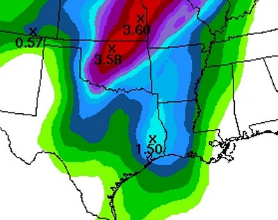
The scattered severe storms this afternoon will form into a line of storms as a fast moving cold front moves towards the area. This will cause the storms to race east and reach our area tomorrow around midday in our western counties and during the afternoon hours across our eastern counties. This line of storms could produce some small hail and gusty winds but the good news is they will bring heavy rain. Much of the area should receive around an inch of rain with a few spots receiving over an inch and a half of rain with this line of storms. The image below shows much of East Texas receiving between 0.75” and 1.50” of rain with this line of storms tomorrow.

By Tuesday evening drier air will be moving in behind a Pacific cool front. Temperatures on Wednesday Morning will drop into the 40s as the dry air cools overnight. On Wednesday another front will move through the area bringing cooler Canadian air into East Texas. This will allow morning lows to drop down into the 30s By Friday with a few spots getting close to freezing. The roller coaster ride of temperatures we normally see in November will continue.

Thursday, November 3, 2011

Wide Spread Frost Possible Tonight

A strong cold front moved through East Texas last night and you can tell, much colder air has moved in. The winds today will still be quite gusty out of the northwest around 20 to 25 miles per hour through the early afternoon hours. As the Canadian high pressure mov0se over East Texas late this afternoon, our winds will die down setting the stage for a very cold evening. By 10PM winds will more than likely be below 5 miles per hour in most areas with the exception being our higher ridge tops across East Texas. In the areas where the winds are below 5 miles per hour, temperatures will rapidly drop. At the same time dew point temperatures, or the temperature at which dew forms on objects, will be well below freezing, in the lower 20s in most areas. This will allow for any moisture that forms on outdoor objects to quickly freeze causing frost to develop. So if the winds do die down early enough most of East Texas will wake up to a frosty start on our Friday. If the winds do not die down below 5 miles per hour, wide spread frost will not form but I would still bring in any tender vegetation you may have.

With much of East Texas expecting frost tonight, some parts of East Texas could experience freezing temperatures towards morning. Again this all depends on the wind speed. With light winds temperatures are allowed to drop very rapidly and can approach the dewpoint. I would not be surprised if a few of our normally cooler locations in the morning dropped to near 30 degrees, possibly even the upper 20s. Freeze warnings have been posted for our northwestern counties but if it looks like the winds will die down early enough, those warnings may be extended farther south and east.

Friday, October 21, 2011

The Orionids Meteor Shower to Peak Tonight, Tomorrow Morning


The remains of Haley’s Comet will intercept the Earth’s orbit late tonight early tomorrow morning producing a meteor shower as these small particles burn up in the Earth’s atmosphere. The peak time for this event will be after midnight and by 2:00AM up to 20 meteors per hour can be expected. Although this is not as active as some meteor showers, Orionids have been known to streak far across the sky looking like balls of fire as they race along the horizon.
So where do you need to look to see this event? In the southeastern sky you will be able to find the constellation giving Orionids their name, the Orion.


It is from this general direction the meteors should fly across the sky. There may be a few clouds tonight but overall, the viewing conditions appear to be fairly good across East Texas tonight into tomorrow morning.

Wednesday, October 19, 2011

Scattered Frost Possible Tonight

A cold Canadian high pressure will move into East Texas this evening. As this occurs very dry air will be in place along with clear skies. With the high pressure moving over East Texas this will allow for our winds to die down to near calm by tomorrow morning. This will provide the perfect conditions for evaporational cooling which will allow for a few places to get downright cold this evening.
A lake wind advisory continues through this afternoon as we will see wind gusts to 30mph. But as we approach sunset the winds will significantly die down allowing for temperatures to cool off rapidly. Dew points (the temperature at which dew forms) this evening will be well below freezing setting the stage for the formation of patchy frost. The following image shows dewpoints ranging from 20 degrees along the I-30 corridor to the middle 20s in our southern counties. This will allow for areas with calm winds to drop well into the 30s. As dew forms, it will be forming on objects whose surface temperatures are below freezing. This will cause patchy frost to form.

Now we are not expecting wide spread frost this evening as most places will remain right around the 38 to 40 degree mark. But in our normally cooler locations temperatures could drop below 38 degrees making the formation of frost more likely. If winds die off soon enough, parts of our northeastern counties could get close to freezing. This is not expected to be a killing frost or freeze but if you have any tender vegetation, you may want to bring them inside.

Thursday, September 29, 2011

Tyler could hit 82 today, I we’re not talking about the temperature

As we head through the end of September, temperatures this afternoon will heat up once again. In a summer that just doesn’t want to end, it looks as though the century mark could be reached again in Tyler for the 82nd time this year. Now let’s put that number in perspective. Over the past ten years combined Tyler has reached 100 degrees 83 times. Over the past 30 years Tyler usually sees 100 degrees 7 times. The good news is the latest recorded 100 temperature occurred in Longview on October 3rd 1953. We are rapidly approaching that date so the end should be near, but this year nothing would surprise me.
Now relief is on the way as a strong cold front heads through the Plains States this afternoon. Out ahead of this front the air mass if very dry so clouds and showers will be hard to come by. Another problem today is out ahead of these fast moving fronts, the air is forced to compress. When this happens the air mass warms and with a lack of clouds, many areas should approach if not surpass 100 degrees this afternoon. But once the front moves through, it will feel like fall.
Temperatures in the northern Plains this morning were in the 30s and 40s with the coldest location I could find being Cut Bank, MT with 26 degrees. Now we will not see temperatures this cold but as this air mass moves south, we have a noticeable difference in our morning and afternoon temperatures. Many areas Sunday morning could be in the upper 40s and only warm into the upper 70s to near 80 degrees during the afternoon. The only thing that would make this forecast better would be the chance of rain which appears absent for the next few days.
So will today be the last time we see temperatures approach 100 degrees this year? There are signs the overall weather pattern is about to change starting next week. The ridge of high pressure that has kept us dry and hot looks to be replaced by a significant trough of low pressure. If this occurs then our rain chances will increase towards the second weekend of October which in turn would keep temperatures lower. This pattern looks to hang around through the middle of October which according to the record books is too late for 100 degree temperatures. But as I stated earlier, this year nothing would surprise me.

Tuesday, September 6, 2011

Why is it so smokey?

I have been getting lots of questions on fires this morning because of the extreme amount of smoke in the area. Many people are worried if there is a fire near them and after the past couple of days, who can blame them? East Texas awoke to a tremendous amount of smoke this morning even though there was not an increase in fires. So how did this happen?

As the sun sets in a cool air mass, the earth cools rapidly causing ground temperatures to be much cooler than temperatures just above the surface. This is known as a temperature inversion. Basically the near ground atmosphere separates from the remainder of the atmosphere. We call this atmospheric decoupling. This also allows for the surface winds to diminish greatly. With the temperature at the surface much cooler than the temperature 500 or so feet above the surface, the smoke becomes trapped in the lowest layer of the atmosphere. As the smoke rises, it hits the temperature inversion and can go no higher so it spreads out across the entire area.

When we look at the sounding data for Tyler, or the temperature profile, the red line shows the air temperature as you go up in the atmosphere. Notice at 7AM this morning there was a strong inversion were the temperature decreases rapidly in the lowest 500 feet of elevation. By noon you can see the inversion in the lowest 500 feet is now gone and this allows for the smoke to mix out. Now there is another temperature inversion around 6000 feet in the atmosphere so the smoke can’t completely clear out but at least it will be a little easier to breath. Depending on what happens with the fires today, we could see a repeat performance of the smoke tomorrow morning.

Tuesday, August 30, 2011

Be sure to fill up before Thursday


Before Irene hit the Eastern Seaboard the price of gas increased just a bit in the fear that the refineries in the Northeast would be damaged by the storm. Now that Irene passed through the area with little affect on the refineries, one would expect the price of gas to drop. However, it looks as though a little surprise could form in the Gulf of Mexico that would cause the refineries in Texas and Louisiana to be in danger. Lee could form later this week.

We have been advertising that the strong ridge of high pressure that has been in control of our weather for most of the summer would split by Thursday allowing an upper air trough to take shape across Texas. This would allow for a tremendous amount of Gulf Moisture to move into the area cooling temperatures and giving us a good chance of rain. It now appears a tropical low will develop in the Gulf on Thursday and depending on how fast it develops, we could see Lee before the Holiday Weekend.

All of the models we use to generate our forecasts have now picked up on the fact that a tropical system will develop in the Gulf. There is however a very large spread in the strength and time of this system. We are also watching a cold front that will be moving towards the Red River on Sunday which could play a huge roll in where this system eventually ends up. If the new short range high resolution model is correct, we could be looking at a strong category 1 hurricane near the Sabine Pass on Friday evening. If this does occur we should see plenty of rain move across East Texas before the cool front arrives on Sunday pushing this system to our south and west. That is the good news. The bad news is the winds would be very strong and we could see wide spread power outages.

Again the above scenario is the worst case scenario now. A lot could happen between now and then that stops this system from developing or keeps it away from East Texas. One thing is for sure though. Once the oil companies get wind of this system developing, the price of gas will go up. All the oil companies have meteorologists on staff so it won’t be long until they are hearing this worst case scenario I mentioned. So the sooner you can fill up, the better.


Friday, August 26, 2011

When Will It End?


Yesterday another mile stone was reached in Tyler as it was the 70th day Tyler reached or surpassed 100 degrees. Yes, 70! To put that number in perspective, the old record for the most 100 degree plus days in Tyler was 47. So Tyler has surpassed the all time record of 100 degree days by 23 days or over three weeks. If our seven day forecast is correct, and I believe it is, Thursday will be day number 77 giving us a month of days above the previous all time record.

The situation is a little different for Longview record wise but it has still been hot. Yesterday was the 62nd day at or above 100 degrees; 2 days shy of the all time record of 64 days set in 1934. Again based on the seven day forecast this all time record will be broken as well.

So when will it end? Well looking at the medium and long range forecast models, there is a chance that Thursday of next week could be our last 100 degree day of the summer. The strong ridge of High pressure that has been dominating our weather for the past 90 days looks as though it will split placing an upper air trough across East Texas starting Wednesday of next week. If this happens it will allow much more Gulf moisture to move across the area and with daytime heating, we would see scattered afternoon storms. It looks as though this pattern could continue through much of the second week of September keeping afternoon storms in the forecast, giving us more soil moisture, allowing for cooler afternoon temperatures. So depending on exactly what happens; September 1st could be the last day we see 100 degrees for the summer of 2011.

But the way this summer has gone, I have to believe we would see at least a couple of days in September at or above 100 degrees. By this time period Tyler could be approaching the total number of 100 degrees day for the years 2001-2010 combined; 83! What we really need to happen is a huge shift in the Jet Stream binging the first real autumn like air mass. Last year this did not occur until the 26th of September when we saw a front move through knocking our highs down into the middle 70s and lows into the lower 50s. The earliest this has occurred in the past 5 years was on the 16th in 2008 after Ike moved through. Today’s long range forecast model shows this occurring on the 10th right now. It is a little early for this to happen but at least the trend is moving in the right direction. Surface temperatures are forecast to be in the middle 50s Saturday morning the 10th with highs in the 70s. Although this forecast is too far out to be very accurate, after this summer I think we all deserve an early arrival to fall.

Wednesday, July 27, 2011

Come on Don!


Yesterday we brought to everyone’s attention there could be a tropical system developing near Cuba. The National Hurricane center had this area under a slight risk of developing but we mentioned the system looked fairly organized and was worth monitoring closely. This morning it is now looking likely this system will develop into a tropical depression later today and possibly Tropical Storm Don. The National Hurricane Center now has this area under a high likelihood of development and is sending an air force hurricane hunter to investigate. Once the plane reaches this system I have a good feeling it will be classified as a depression.

Now for the good news. It appears the timing of this system along with the eastward movement of our strong high pressure that has been baking us all summer, will allow for lots of tropical moisture to invade the area. So even if what could become Don moves to our south, the chances of seeing afternoon thunderstorms will increase greatly Friday and Saturday and should bring an end to the steak of 100 degree days.

It is not all good news however. If this system moves farther north that could put East Texas in the area we would need to monitor for weak tornadoes that occur with land falling tropical systems. Also, with the extremely dry ground, rapid run off could occur with very heavy downpours giving parts of East Texas a threat of flash flooding.

We will continue to monitor this system over the next few days. I for one could deal with a little severe weather if it means rain and an end to the extreme heat. One thing is for sure. If we do not get a decent amount of rain with this system, next week will be very hot with highs approaching 105 degrees again as our friendly high pressure ridge builds back in.

Tuesday, July 26, 2011

Could Don be out There?


HWRF Model showing a strong tropical storm with 68 mph winds
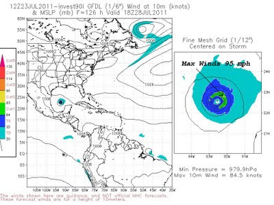
GFDL Model shoing a strong Cat 1 Hurricane with top winds of 95 mph
Tropical forecast models were hinting at a developing tropical system a couple of days ago. Some of the high resolution models were showing a strong tropical storm or hurricane by Friday morning. If this were to happen the storm’s name would be Don. Right now the models have backed off on this development but it will be interesting to watch. It seems as though this disturbance has become a little better organized the past 24 hours. This could be just what East Texas needs, a tropical system moving to our south but close enough to send in lots of tropical moisture increasing our chance of rain. If this system takes a more northerly track we could see locally heavy rain over the weekend.


If it moves farther south, East Texas would be mostly dry and very hot. Right now it appears the second scenario is more likely but we will continue to watch this developing system.

Monday, July 18, 2011

I'll Hold at 20 but................

20 days. That is where Tyler stands right now on the record setting number of days at or above 100 degrees. This ties the record for any reporting station in Tyler reporting 100 degrees or more in a row. The previous record ended in August of 1998 when Tyler had a run 20 days. That same year Longview had 21 days in a row at or above 100 degrees. Right now Tyler and Longview are both holding with 20 and 18 days respectfully. However it looks as though the dealer may not be done and both cities could bust in respect to the 21 you want in Black Jack. What is the next card to be dealt? We will have to see. But there is a chance the dealer is holding a 7 which would give Tyler a 27 and Longview a 25, both big busts!

Tuesday, July 12, 2011

Crazy From The Heat Records

Yesterday was another day with temperatures above 100°F making it the 14th straight day in Tyler and the 12th straight day in Longview. The only thing crazier than the heat in my opinion is trying to keep up with all the heat records for East Texas. Yesterday I stated that the longest stretch on record for Tyler was 16 days in 1980 and the longest stretch of days for Longview was 10 days in 2006. Well, that is not entirely true and it starts to get real confusing. So I will try to straighten up all the confusion today, remember I said try.

The problem with weather records here in East Texas is the “official” site has changed many times throughout the years and is actually pretty hard to find when doing research. The “official” weather observation site for Tyler has been at the Tyler Pounds Airport since May of 2000. In Longview the “official” site has been at the East Texas Regional Airport since February of 2001 but since the National Weather Service used to be stationed in Longview, there have been reports from the airport since the mid 70s.

There are also many other “unofficial” sites that have kept data over the past 100 years or so. One of those sites showed Tyler had a stretch of 16 days above 100 degrees in 1980 however; the “official” site the Weather Service uses shows only 12 straight days above 100 degrees. Confused yet? So am I.

Well, after a lot of research my friend from the Nation Weather Service in Shreveport Jason Hansford has given me an “official” record that they will be using for the longest stretch of 100 degree plus days for Tyler and Longview. The year was 1998 with Tyler going 20 days and Longview going 21 days at or above 100°F. But remember, these readings were from different locations than we use today. The 21 days for Longview actually occurred 11 miles to the southeast of Longview and not at the airport. The airport only recorded 12 days in a row that year.

So unless we see the triple digit heat linger into the first part of next week, the “official” records appear to be safe. However, since the ASOS (Automated Surface Observing System) has been commissioned in both Tyler and Longview, this stretch of 100°F plus days is the longest.

Monday, July 11, 2011

When Will It End?


For much of East Texas June was the hottest June on record and July is starting off much the same way. If the forecast high temperatures are reached today across East Texas it will make the 14th straight day that Tyler as hit or surpassed 100°F. This is the second longest stretch of 100°F plus days on record. The longest on record is 16 days in 1980. Today would be the 12th straight day of 100°F heat in Longview, the longest stretch on record. So why has it been so hot?

Well, if you can think back to April when we first started to see the mercury hit the 90°F mark, we began to mention if we do not see a significant amount of rain we were in for a very hot summer. The reason for this is because of how dry our soil is here in East Texas. As the sun shines down on the Earth’s surface, much of its energy is used to evaporate soil moisture causing the ground to remain relatively cool. This year we have seen soil moisture extremely low across East Texas. When this happens all of the sun’s energy can be used to heat the ground which in turn heats the air. The hotter the soil temperature, the hotter the air will become. For the majority of East Texas the soil moisture is less than 5% of what it normally should be for this time of the year. On Saturday the 10th the soil moisture for much of East Texas was actually less than 1% of what we normally see. (The dark red shading across the southern 2/3rds of East Texas indicate less than 1% of normal soil moisture)

This is not good for the hopes of seeing cooler temperatures anytime soon. Even if we are able to see afternoon and evening thunderstorms develop, the amount of aerial coverage will not be enough to cause an increase in soil moisture to bring temperatures back to a normal level. East Texas’ climate this year is becoming more like what you would find across west Texas where dry soil leads to 100°F quite often. The only real hope we have of seeing a significant increase in soil moisture is if a tropical system moves into our area bringing widespread 3 to 5 inches of rain.

Hopefully this will happen. The Atlantic Hurricane seasonal forecast is above normal this year. Of course we do not need a tropical storm or hurricane to cause a significant amount of damage to the area. What we need is a tropical depression to move into the area and stay for a day or two providing widespread heavy rain. This would give us the average amount of soil moisture we usually see giving us average temperatures instead of well above temperatures. If we do not see this we may set all time record high temperatures across East Texas this summer. In Tyler we hit 105°F in June tying the all time record for the month. The all time record high for Tyler is 111°F and for Longview is 113°F. As many tell me, “This is summer in East Texas. It’s supposed to be hot!” Well not this hot. But don’t worry. We are only 91 days away from our average highs being in the upper 70s, and it can’t get here soon enough.

Friday, July 8, 2011

Another shot from the 5th


Yes, the 5th of July. A few left over fireworks and a strong storm combine for a beautiful shot.