Yesterday I showed you the conditions coming together for a conditional threat of severe weather across East Texas. Today after looking at the latest data it appears the EML (elevated mixed layer) or cap will be to strong across East Texas for thunderstorm development. All the other conditions I mentioned in yesterday’s write up are still coming together so if A storm were able to develop, it would likely become severe rapidly producing large hail, gusty winds, and tornadoes. But that just doesn’t appear likely.
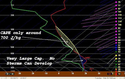
When we take a look at the forecast sounding for this afternoon we notice a very large area of CIN (convective inhibition). This is a large amount of negative energy (blue shaded region), or sinking air, that would not allow upward motion of air parcels allowing for thunderstorm growth.

Now yesterday I mentioned this as well and was concerned what would happen if we saw a few more breaks in the clouds allowing for warmer afternoon temperatures, like we saw yesterday. Well when the forecast sounding is modified for a surface temperature around 76°F it looks a lot more conducive for thunderstorm development. Notice the area of CIN (blue shaded area) is much smaller than the actual forecast. Also the amount of CAPE, or buoyant energy (yellow shaded area), is much greater. This could allow for explosive thunderstorm development if we see surface temperatures warm into the upper 70s this afternoon.

Again in theory severe weather is possible this afternoon based on forecast soundings. That is why looking at the actual sounding is so important. So this morning I wanted to see what was happening downstream from East Texas because this air mass will be over us later today. By looking at the actual sounding from Del Rio area we can see the EML is very strong with a temperature of 15°C at 800mb. We you modify the forecast sounding for that 800mb temperatures the convective temperature, or the temperatures at where air rises freely allowing thunderstorms to develop, is well into the 80s which we will not see today. So based on all the information I see right now East Texas appears to be safe from severe weather this afternoon. We will see a line of showers and storms move in overnight but by that time the dynamics for severe weather and tornadoes will be off to our north and east. But if the temperatures are able to reach the upper 70s to near 80, there could be an isolated severe storm late today but right now that does not seem very likely at all.

 When we take a look at the forecast sounding for this afternoon we notice a very large area of CIN (convective inhibition). This is a large amount of negative energy (blue shaded region), or sinking air, that would not allow upward motion of air parcels allowing for thunderstorm growth.
  Now yesterday I mentioned this as well and was concerned what would happen if we saw a few more breaks in the clouds allowing for warmer afternoon temperatures, like we saw yesterday. Well when the forecast sounding is modified for a surface temperature around 76°F it looks a lot more conducive for thunderstorm development. Notice the area of CIN (blue shaded area) is much smaller than the actual forecast. Also the amount of CAPE, or buoyant energy (yellow shaded area), is much greater. This could allow for explosive thunderstorm development if we see surface temperatures warm into the upper 70s this afternoon.
 Again in theory severe weather is possible this afternoon based on forecast soundings. That is why looking at the actual sounding is so important. So this morning I wanted to see what was happening downstream from East Texas because this air mass will be over us later today. By looking at the actual sounding from Del Rio area we can see the EML is very strong with a temperature of 15°C at 800mb. We you modify the forecast sounding for that 800mb temperatures the convective temperature, or the temperatures at where air rises freely allowing thunderstorms to develop, is well into the 80s which we will not see today. So based on all the information I see right now East Texas appears to be safe from severe weather this afternoon. We will see a line of showers and storms move in overnight but by that time the dynamics for severe weather and tornadoes will be off to our north and east. But if the temperatures are able to reach the upper 70s to near 80, there could be an isolated severe storm late today but right now that does not seem very likely at all.
No comments:
Post a Comment