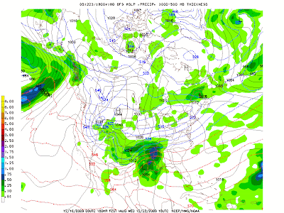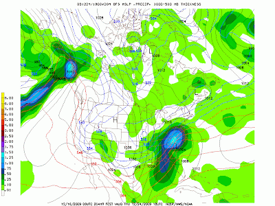
Every year around this time most everyone I meet and talk with ask me one question. Will we have a white Christmas? Unfortunately for all the snow lovers here in East Texas, snowfall is a rare occurrence, even more so on Christmas Day. Judging strictly on climatology data, the odds of seeing a white Christmas here this year are very slim, less than 20%. So what will happen this year?
I want to stress that what you are reading is not a forecast but is a trend on what we might expect this Christmas. Right now it appears a cold front will sweep through East Texas on Wednesday the 23rd. The air mass behind this front will be of arctic origin so we can expect cold temperatures Christmas Eve and Christmas Day. As this front moves through, showers can be expected out ahead of this front on Wednesday. Now for the interesting aspect to this trend. The latest long range forecast models are developing an area of low pressure along this front. The current placement of this low pressure Wednesday would give parts of the Gulf Coast region a chance of severe weather.

As this low intensifies and moves northeast, cold air with moisture would wrap around giving much of East Texas a chance of snow flurries or light snow showers. Temperatures would be very cold behind this front so any snow that falls would have a chance of accumulating. The window of opportunity for snowfall would last through early Christmas Eve Morning.

For Christmas day, very cold air would be in place with morning low temperatures in the teens and highs struggling to reach the 30s. For those planning to travel to the Northeast, an all out blizzard could be expected with this system.

Again, what you have just read is not my official Christmas Forecast. Right now my official forecast would call for dry, cold conditions with lows in the 20s and highs in the 40s. But it is always fun to look at all the possibilities of what “could” happen around Christmas.
This trend will more than likely change many times between now and Christmas. Keep checking back as I will post updates on what you might expect this Christmas weather wise.

7 comments:
How exciting to think that my Christmas in East Texas this year might include a snow flurry or two. Please keep us updated.
The GFS is sure going crazy with is especially the 06Z run. If the )6Z run came to fruition we would be dealing with a near blizzard. It basically shows a Blizzard of 96 storm.
Would love a White Christmas, but this could create one of the worst combos of high volumes of travelers and delays imaginable.
6Z GFS is a little crazy but check out the 12Z. Nice snow storm for East Texas a few days after Christmas. This of course will change. Don't believe it until it is within 4 days.
I love creating my own forecasts this time of year, watching the models and all of the other things that factor into it. It's a good diversion from studying so I am glad there was nothing on the table during finals.
But I want it to snow! Make it happen!
On the flip side, I would rather it wait until after I am supposed to go back to work, say, a January 2 blizzard? That works better for me. I won't have to go in!
I am not going to count on this, of course, as it is still over a week until Christmas, but it is FUN to think about. You and Mr. Scirto please see if you can't convince someone at the National Weather Service to pull some strings and get this to happen. :)We East Texans will be forever in your debt if you can work it out.
The overall trend for this system is to move the low farther north. this means not a great chance of snow. It also means we could have to deal with severe weather Wed. The 12GFS paints a pretty high severe weather potential. If surface dew points make it into the lower 60s, we could see a tornado threat.
Post a Comment