Tuesday, November 30, 2010

Sleet and Snow at 45 Degrees?


A cold front moved through the area yesterday ushering in cooler and drier air to East Texas. Behind the front precipitation developed in the colder air in the form of snow around 12,000 feet in the atmosphere. As this snow fell towards the surface, most of it evaporated not reaching the surface. However, in a few areas where the precipitation was heavy enough, light rain and sleet did make it to the surface mixed at times with a few snowflakes. So how is it possible for sleet and snow to reach the ground when the surface temperature is well above freezing, in the middle 40s?

Well, you have to look at the temperature and moisture content of the entire atmosphere to see if sleet and snow will reach the surface, not just the surface temperature. By looking a forecast sounding from Tyler this morning, or a profile of the atmosphere, precipitation was developing in an area where the temperature was between -10°C and -20°C, the perfect temperature for snow crystal growth. As the snow fell from the clouds it entered a layer of the atmosphere that was very dry allowing most of the precipitation to evaporate. However, in areas where the precipitation was heavy enough, a few flakes remained. Once the snow reached around the 5000’ mark in elevation it entered an area where the temperature was slightly above freezing. So much of the remaining snow partially melted in this layer only to refreeze, in the form of sleet, as it entered below freezing temperatures again around 4000’ in elevation.

Now according to the forecast sounding for Tyler the depth of above freezing temperatures from the surface was about 1900’, usually enough to melt the sleet and snow before reaching the surface. But another temperature that is very important in winter weather forecasting in the wetbulb temperature or the temperature that would be reached when evaporation occurs. The depth of the above freezing wetbulb temperature this morning was only around 800’. So in areas of more intense precipitation this morning, the process of evaporational cooling would bring temperatures to the wetbulb level allowing sleet and snow to reach the surface. I must say I expected a little light sleet this morning, like we saw last Friday. But I was very surprised to see a few snowflakes hitting the wind shield this morning until I analyzed the forecast sounding. There always seems to be something exciting in the world of weather.

Friday, November 19, 2010

A Cold Thanksgiving?

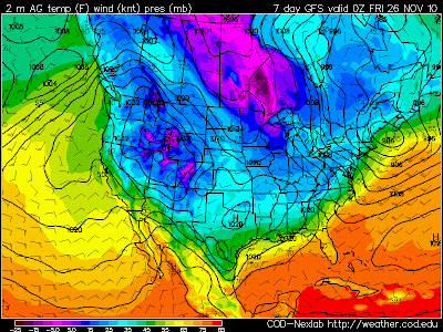
An arctic air mass is building in Northern Canada and looks to move south into the United States next week. Temperatures this morning were as low as -35°F in Canada and this air mass will slowly drift south the next few days. By Wednesday Morning temperatures look to be between -10°F and -20°F across Montana and the Dakotas. Wed 6AM Temps
As this air mass moves south, it will moderate considerable due to the lack of snow cover across the country. But it still should be the coldest air we have seen this year across East Texas. How cold? Well we could be looking at temperatures falling through the 40s on Thanksgiving Day and bottoming out in the 20s by Friday Morning. So “Black Friday” looks to be mighty cold for all the shoppers looking for a good deal.6PM Thanksgiving Temps
Of course this is all a few days out and a lot could change between now and then. The biggest challenge with this forecast is the fact the upper level winds will be parallel to the front as it moves across the Plains. This sometimes can slow down or even stall the frontal passage. However, arctic area is very shallow and dense and usually will slide under the upper level winds. So right now I really don’t see anything stopping this air mass from making it our way.
Another interesting aspect of this forecast is the potential for an over running precipitation event. Right now the forecast looks dry behind the front but, with the upper level wind out of the west southwest, Pacific moisture could lift over the cooler air at the surface. Normally this causes clouds and rain to develop. This is also how we usually see our icy events in East Texas but this air mass does not look as though it will be cold enough. At the same time Pacific air could be lifting over the colder Canadian air, East Texas will be in a favorable area for lift, in the right rear section of a jet streak. You combine this with an upper air disturbance that is forecast to move into the area on Thanksgiving we could be looking at a cloudy day which would make our high temperature much colder with a few scattered showers.
Again, we are still a few days out from this frontal passage and a lot can change between now and then. Our official forecast for Thanksgiving is for partly cloudy skies and high temperatures in the middle 50s. But don’t be surprised if this forecast changes and is colder by the time we get into next week and have a better grasp on what this arctic air mass will do.

Thursday, November 11, 2010

A Narrow Opportunity for Severe Weather Tomorrow


Severe storms are possible tomorrow across northern Texas and central Oklahoma ahead of a very strong 500mb vort max moves across the Texas Panhandle into western Oklahoma Friday evening. Even though low level instability will be much lower than usual for severe thunderstorm development, the dynamics of this system appear to be enough to overcome this limitation. All the following forecast information is based off the 11/11/10 12Z NAM.
Right now SBCAPE is forecast to be between 500 and 700 J/kg for a narrow window of time Friday afternoon, with nearly 100 J/kg in the lowest 3KM of the atmosphere. If any additional daytime heating can occur, SBCAPE could reach 1000 J/kg in a few areas.

In addition to the available instability, 0-6km shear will me more than ample for supercell development. Shear values will be close to 50 knots over the greatest axis of instability which could promote robust rotating updrafts. Also, the shear vectors will remain perpendicular across the boundary of storm development so look for to develop in a non-linear form making supercells a likely storm mode

As for the tornado threat, 0-1km SRH is over 200 for a few hours ahead of the cold front so any storm that can develop in this environment could produce enough low level rotation. This along with 0-1km shear values over 20 knots should be enough to allow an isolated tornado or two to develop if storms can initiate ahead of the cold front.

Right now the SPC has a 5% chance of severe weather in this area with a mention of a supercell or two. I do believe that if the forecast trend the NAM is indicating continues a slight risk will be issued, maybe as early as the next day 2 outlook.