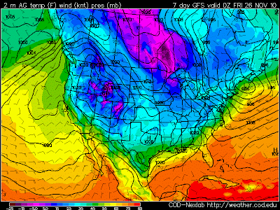
As this air mass moves south, it will moderate considerable due to the lack of snow cover across the country. But it still should be the coldest air we have seen this year across East Texas. How cold? Well we could be looking at temperatures falling through the 40s on Thanksgiving Day and bottoming out in the 20s by Friday Morning. So “Black Friday” looks to be mighty cold for all the shoppers looking for a good deal.

Of course this is all a few days out and a lot could change between now and then. The biggest challenge with this forecast is the fact the upper level winds will be parallel to the front as it moves across the Plains. This sometimes can slow down or even stall the frontal passage. However, arctic area is very shallow and dense and usually will slide under the upper level winds. So right now I really don’t see anything stopping this air mass from making it our way.
Another interesting aspect of this forecast is the potential for an over running precipitation event. Right now the forecast looks dry behind the front but, with the upper level wind out of the west southwest, Pacific moisture could lift over the cooler air at the surface. Normally this causes clouds and rain to develop. This is also how we usually see our icy events in East Texas but this air mass does not look as though it will be cold enough. At the same time Pacific air could be lifting over the colder Canadian air, East Texas will be in a favorable area for lift, in the right rear section of a jet streak.
 You combine this with an upper air disturbance that is forecast to move into the area on Thanksgiving we could be looking at a cloudy day which would make our high temperature much colder with a few scattered showers.
Again, we are still a few days out from this frontal passage and a lot can change between now and then. Our official forecast for Thanksgiving is for partly cloudy skies and high temperatures in the middle 50s. But don’t be surprised if this forecast changes and is colder by the time we get into next week and have a better grasp on what this arctic air mass will do.

No comments:
Post a Comment