For February we saw a very active sub-tropical jet remain to our south along with the polar jet bringing very cold air to the region. This lead to a couple of major snow events in East Texas including up to a foot of snow near Canton on the 11th through the 12th. Another interesting fact for February was there were no tornadoes in the U.S. It looks as though the last time the U.S. went tornado free in February was 1947. Also the last month without a tornado in the U.S. was January 2003, which later became very active severe weather season. (For more information on this click here)
***UPDATE***
There is now an official report of one tornado that touched down near Taft, CA. Here is the report from the National Weather Service:
PRELIMINARY LOCAL STORM REPORT NATIONAL WEATHER SERVICE SAN JOAQUIN VALLEY CA 323 PM PST TUE MAR 02 2010 ..TIME... ...EVENT... ...CITY LOCATION... ...LAT.LON... ..DATE... ....MAG.... ..COUNTY LOCATION..ST.. ...SOURCE.... ..REMARKS.. 0445 PM TORNADO 15 NE TAFT 35.30N 119.27W 02/27/2010 F0 KERN CA TRAINED SPOTTER TRAINED SPOTTER REPORTED A WEAK TORNADO THAT LASTED ABOUT 3 MINUTES ABOUT 15 MILES NORTHEAST OF TAFT. NO DAMAGE WAS REPORTED. RATED EF0.
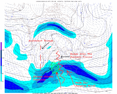
Well, it looks as though now the pattern will shift once again. A deep trough looks to develop over the western U.S. and this will help send much warmer weather into the Southern Plains and Southeast. It looks as though the polar jet will retreat to the north with an active sub tropical continuing to our south. This will allow warmer weather to filter in to the area with the threat of thunderstorms developing.

The first large scale severe weather event could unfold across the Southern Plains Sunday through Monday. Right now it appears a strong surface low will develop in eastern Colorado Sunday bringing warm moist air into the area. How much moisture makes it in to the Plains will be the determining factor. Mid range forecast models have been flip flopping on the amount of instability and buoyancy available for thunderstorm development. The amount of wind shear needed for supercell development should not be an issue. So if enough moisture makes it into the Southern Plains we will more than likely see severe thunderstorms develop Sunday afternoon through Monday. Large low level clockwise hodographs would indicate there would be a threat for tornadoes with surfaced based convection.

So after a slow start to what normally would be an active severe weather season thanks to El Nino could be about to ramp up. If the storm track in February would have been a couple of hundred miles farther north, we would have seen at least threes sever weather events instead of snow here in East Texas. Well, the storm track is moving north again.

No comments:
Post a Comment