Monday, September 13, 2010

Igor Could Become a Cat 5 Storm!


Hurricane Igor continues to strengthen as he moves across the Atlantic. It now appears Igor could become a rare category 5 hurricane later today as top winds could peak above 160 mph. The high resolution visible satellite image above shows Igor having a well defined eye with bright white clouds surrounding the center of the storm. This indicates Igor’s eye is surrounded by very tall thunderstorms or deep convection as we like to say in the weather world. The image below gives us an enhanced look by adding colors to the cloud tops. The colder temperatures are indicated by the orange and red colors. Notice the red nearly making a circle around the eye indicated very tall clouds and a healthy eye wall.

So where will Igor go? Thankfully for the United States Atlantic Coast it appears a blocking high pressure will keep Igor out to sea. Most computer models send Igor and the weaker storm to follow Julia out in the central Atlantic. However, we will need to monitor the stronger high that is located southwest of Great Britain. There are a few models that weaken the High over the U.S. and strengthen the high over the eastern Atlantic. If this does happen Igor could be pushed to the west towards the New England coast. In the aforementioned scenario, Igor could make landfall near New York City as a category 2 or 3 storm but at this time this seems highly unlikely.

We are monitoring another area of disturbed weather south of Cuba. This tropical disturbance could become a depression over the next couple of days. Right now it appears this system will move west and hit the Yucatán Peninsula continuing west into Central Mexico. This last system has the best chance of any to make it to the U.S. Mainland so we will continue to watch it closely.

Thursday, August 12, 2010

Major Snow Storm...Six Months ago!

What a difference 6 months makes. Six months ago today all of East Texas awoke to one of the greatest snowfalls in East Texas history. Snowfall amounts ranged from just over an inch in the Lufkin area to a foot of snow in Canton. Other substantial amounts were 8” in Athens, 6” in Tyler, and 7” in Longview. The winter of 2009-2010 was a much colder winter than we usually see in these parts thanks to a fairly stagnant weather patter allowing cold air outbreaks to surge into East Texas throughout the winter months. An accumulating snow even occurred on the first day of spring in East Texas. So after such a cold winter, why has our summer been so hot? Well, we once again are in a stagnant weather pattern keeping a strong ridge of high pressure over East Texas. This area of high pressure has allowed high temperatures to remain near the century mark for nearly 10 days.

Now this heat has been extreme but it has not been record setting. High temperatures have remained about 5 degrees cooler than record high temperatures and we can expect this trend to continue. So yes it has been a very hot summer, especially late July until now, but it has been much worse. The summers of 1921, 1936, 1939, 1980, and 1998 all and numerous consecutive days with record high heat. When will it end? I know the funny and trendy answer here is to say October but, we usually see a fairly significant Canadian air mass move into the area during September. Temperatures in northern Canada and northern Alaska have been cooling down rapidly and we have even seen some snow in these areas. A strong area of low pressure will send some of this air south next week but by the time it reaches the lower 48, the air mass will modify greatly. So I know it seems as though this heat will never end but trust me, in a few weeks it will just be a memory, like our historic snow earlier this year.

Wednesday, July 28, 2010

South Dakota May Have Set a New Record for Hail Size


A new weather record for the United States could have been set last week in South Dakota. A hailstone that appears to be 8” in diameter fell in Vivian, South Dakota FridayVivian, SD Hailstone
afternoon and this would break the record of 7” with fell in Aurora, Nebraska in 2003. Aurora, NE HailstoneForecasters from the National Weather Service out of Aberdeen, SD will make the drive to Vivian to see if the hailstone officially will break the record. Damage reports range from busted car windows to holes punched through the rooves of houses, even reports of large hail landing on the floor of one resident’s living room.

But the 8” stone may not have been the largest from this day. According to the Rapid City Journal one resident of Vivian, Punk Strom, found a stone that had been outside for over and hour and a half and still weighed 1.8 pounds when he weighed it at the Vivian post office. This would break the record for heaviest hailstone in the United States of 1.6 pounds which fell in Coffeyville, KS in 1970. We should know later today whether or not this hailstone sets a new record for the United States.

Thursday, July 22, 2010

Bonnie Brewing.....


A new tropical depression has formed southeast of Miami, FL and could become Bonnie as early as this evening. This system has been struggling to develop over the past couple of days due to an upper level low pressure just east of the surface low. This upper low has been shearing the western side of the circulation keeping it from developing faster. It looks as though this upper low will move off to the northwest but remain close enough to this depression to keep it from developing into a hurricane. The current forecast brings this system into the Texas Gulf Coast late Sunday early Monday as a tropical storm.
The forecast also brings this storm into East Texas providing a chance for cooler weather and the possibility of heavy rains but it must be noted that the average error past four days is over 200 miles. So a lot could and probably will change between now and Monday morning.

Wednesday, July 14, 2010

Dangerous Heat in East Texas


Dangerous heat is expected across East Texas today as mostly sunny skies warm temperatures in to the middle and upper 90s this afternoon. Combine this heat with the relative humidity across East Texas today and heat index values will range between 103 and 108 degrees. Because of this, heat advisories have been issued for East Texas through tomorrow evening.

Tomorrow will be very hot as well with highs in most places ranging between 97 and 100 degrees with the heat index approaching 110 degrees at times. Once the heat index reaches 105 degrees, the human body has a very hard time cooling itself. Please postpone strenuous outdoor activity until the cooler morning or late evening hours. If you have to be outdoors, wear light weight light colored clothing and drink plenty of water. Heat exhaustion will set in very fast during the afternoon heat. This could lead to heat stroke and possibly death. On average 162 lives are lost due to heat in the United States each year, about the same amount of deaths caused from floods, lightning, and tornadoes combined! Please take the heat seriously and stay cool.

Monday, June 28, 2010

Alex to Become a Hurricane


Tropical Storm Alex has now entered the Western Gulf and will more than likely be a hurricane this time tomorrow. Conditions are very favorable for a rapid development of Alex with warm water and a lack of wind shear. The current forecast track is still brings Alex just south of Brownsville, TX as a strong category 2 hurricane early Thursday. However the overall trend of the tropical forecast models we use is to bring the path of Alex farther to the north. This could not only bring some of the effects to East Texas, but could allow Alex to strengthen to a category 3 hurricane by remaining over the Gulf a little longer.

So what does this mean for your 4th of July Holiday Weekend? Right now if Alex moves on its official track, East Texas would remain dry and hot with highs reaching the lower to middle 90s. If Alex moves farther north, the forecast changes drastically. Alex appears as though it will be a very large storm with tropical storm force winds extending at least 200 miles from the center. This large circulation would pump lots of Gulf moisture into the area providing thunderstorms with heavy rain to the area Thursday through Saturday.

The greatest threat from Alex will be very heavy rain. Alex is forecast to move very slowly no matter which path he takes. Rainfall rates of over 10 inches could occur along Alex’s path through Saturday. So flash flooding could be a big concern to parts of East Texas if Alex takes a northerly path.

Another threat from Alex as with any land falling tropical system would be isolated weak tornadoes. The northern and eastern quadrants of Alex could produce thunderstorms capable of spawning tornadoes. If Alex moves farther north, then the tornado threat could move into parts of East Texas, especially our southern and western counties.

We will have a much better grasp on Alex and his forecast track over the next 48 hours. We could see anything from sunny hot conditions this upcoming Holiday Weekend to heavy rain and flooding. Please stay with your East Texas News Leader for the latest developments on Alex and its potential effects on East Texas.

Wednesday, June 23, 2010

Tropics Heating Up!


A tropical disturbance that we have been watching for nearly a week is now becoming better organized in the Caribbean Sea. If you recall this system was located out in the central Atlantic last week in an area that was favorable for development. But most tropical systems climatologically have a difficult time developing that far east and this one followed the same fate.

Now the disturbance is in a more favorable area both meteorologically and climatologically for development. The eventual path of this tropical system is still up in the air as tropical forecast models show this system moving anywhere from Brownsville, TX to Mobile, AL.
In fact the GFLD model shows this system becoming a major hurricane with top winds near 120mph off the Louisiana Coast by late Sunday early Monday.
However the HWRF model shows this system as a strong tropical storm with top winds near 70 mph off the coast of Mobile, AL by Tuesday.
The overall strength of this tropical system will depend on the eventual path it takes. The Yucatan Peninsula is very important to the development of this storm. If it can say over the water and not pass over land, like the GFLD indicates, this system would have the time and energy needed to become a Hurricane. If it moves over the peninsula, it would more than likely remain a tropical storm or not develop at all. Only time will tell.

At the same time this is occurring, a fairly strong surface high pressure is forecast to develop over the Great Lake States and send a backdoor cold front into the area. If this does occur then the overall path of this tropical disturbance would be more to the west making the Texas Gulf Coast a likely landfall.

So how would a tropical storm or hurricane affect the oil spill out in the Gulf? Would the spill have an impact in its intensity? Will a strong hurricane spread oil over most of the Gulf region? These are many questions I have been receiving over the past few weeks. These are all great concerns so I will tackle them for you the best I can.

First let’s look at the strength of a tropical system being affected by the oil spill. It has been theorized that if we were to place a significant amount of oil in the path of a hurricane, this would stop the amount of warm water the storm could ingest, acting like a barrier. While this could have some truth during initial storm creation, with a storm that has already developed this would not be the case. The waves and rain out ahead of the storm would dilute the oil greatly, not making it a barrier what so ever.

Which brings us to our next question, would this hurricane spread oil to all areas of the Gulf? In all actuality, a hurricane would bring some oil inland with the storm surge and this could cause some problems. But the overall affect the hurricane would have on the oil in the Gulf would be to dilute it. The heavy rain, high winds, and turning seas would help accelerate the break down process more than if we did not have a hurricane.

Another question that I have been getting is will the oil spill cause the hurricane to rain down oily rain. The answer to this is no. The amount of oil spilled so far, although staggering, is only a drop in the bucket so to speak to the amount of water vapor evaporated and stored in the storm. So the hurricane clouds would be made of water vapor thus the rain would not contain oil. For more on hurricanes and oil spills, please read this article from NOAA.

Monday, June 14, 2010

Wednesday, June 9, 2010

Slight risk of Severe Storms Today

An area of low pressure is spinning across the Hill Country this morning and promises to bring a chance of storms to the area. Our Western Counties are already under a flash flood watch as we anticipate at least 2 inches of rain across our western counties with isolated areas receiving between 2 and 4 inches of rain.

In addition to the heavy rain threat, there is a slight risk of severe thunderstorms with the main threat being gusty winds and weak tornadoes. The area of low pressure to our south is acting very much like a tropical low. As with any land falling tropical system, there is a chance of a few tornadoes and we see that threat today across East Texas, mainly our Southwestern Counties from Athens to Alto and southwest.

This area of low pressure will be with us again tomorrow keeping the chance of thunderstorms around. As we head towards the weekend however, we will begin to dry out and heat up with mid 90s heat returning.

Tuesday, June 8, 2010

NE Colorado Supercell 6.6.10


Tornado Warned supercell south of Ft. Morgan, CO 6/6/10. There was a report of a tornado touchdown but from our vantage point we did not see it. We sat on this storm for about 2 hours. The first part of the video is of the rotating base and wall cloud. the second part of the video shows the back side of the storm with mammatus and lots of lightning. The last few frames of the time lapse is of a second supercell that moved in behind the first storm. Notice the cork screw appearance to the updraft tower.

Thursday, May 27, 2010

Looking Towards Memorial Day

Well some much needed rain hit arts of East Texas yesterday but will this rain ruin your Holiday Weekend plans? Today we will see hot and humid conditions again today but, not quite as humid as yesterday. This will keep the overall coverage of thunderstorms less from what we saw yesterday. A few places could receive some much needed rain but it looks like the chances of rain where you live today are less than 20 percent. Any storm that forms today could produce small hail and strong gusty winds although we are not anticipating much in the way of severe weather.

Tomorrow a ridge of high pressure in the upper levels of the atmosphere will begin to build back into East Texas. This will cause the air to sink across most of the area eliminating the threat of afternoon storms. The one exception to this will be across our far southern counties where from Crockett to Lufkin to Hemphill we could see an isolated storm tomorrow afternoon.

This ridge will of high pressure will stick around through Sunday keeping most of East Texas dry and warm. Some slightly drier air will mix down during the afternoon hours so the heat index will not be quite as hot as we have seen this week. This should also allow for nighttime temperatures to dip down into the middle to upper 60s.

As we head towards Memorial Day, it looks as though most of East Texas will continue to remain dry. The ridge of high pressure will begin to break down just a bit so we can’t rule out a pop up storm developing but I wouldn’t cancel those outdoor barbeques just yet. You can always see the weather where you live by clicking out interactive radar to help you with your outdoor plans.

Stay safe and everyone have a great Memorial Day Holiday, and remember why we celebrate.

Wednesday, May 26, 2010

May 20th 2010 Storm Chase

Well it has taken me awhile but I am finally writing my chase account from last Thursday May 20th. The severe weather set up from Thursday event included an outflow boundary interacting with a stationary front across Central Texas just south of Dallas.
Early in the afternoon strong to severe storms developed along and north of a southward moving outflow boundary from Wednesday’s convection farther north. These storms became severe and produced wind damage in the Dikes community of Hopkins County, just east of Sulphur Springs.

It was along the intersection of the southwestward moving outflow boundary and stationary front where supercells would continue to develop throughout the afternoon and move off to the south and east. There were two official tornado reports and numerous reports of large hail, up to baseball size.theloop@kltv.com


The first storm we encountered was in Henderson County near the Cedar Creek Reservoir. This storm was showing signs of weak rotation but no true wall cloud feature was seen while we were on the shores of Cedar Creek Reservoir. As we drove south from Tool along 247, we noticed an elephant trunk shaped funnel extending towards the ground. From our vantage point we could not tell if this funnel reached the ground or not. By the time I could snap a shot of the funnel, it was much farther off the surface and more horizontal. This storm continued to produce these funnels that would not quite reach the ground. It looked as though as these funnels lowered, the cooler air from behind the outflow boundary was undercutting the updraft causing them to rope out before even reaching the ground. This storm produced at least three funnels before moving away from our vantage point.

From this storm we raced west to catch the latest storm that had developed along the intersecting boundaries. This storm was showing signs of strong rotation both on radar and from our ground view. Although this storm would not go on to produce a tornado, large hail did occur. We were hit with quarter size hail wrapping along the back side of this storm..

Our third storm became the storm of the day for us developing near Waxahachie and moved southeast through Navarro and Freestone Counties. This storm would go on to produce wind damage and hail up to the size of Baseballs near Corsicana. From our vantage point it also appears that a brief but rather wide tornado could have touched down over Richland Chambers Lake.

As we approached this storm radar showed a very well developed deep convective supercell, a constant midlevel rotation was show on this storm for well over an hour.
As this storm moved over, we raced south to stay out of the hail core. For a time we were under a large rotating wall cloud. It was during this time that I witnessed an event I have never seen before. We noticed mini vortices about 5 feet in diameter rotating around the wall cloud. Three or four of these little vortices moved in front of our vehicle. The did not appear to be in contact with the storms updraft but it was interesting that these dust devil size vortices were moving in the direction of the parent circulation. Were these mini vortices a precursor to a developing tornado? I am not sure but it was an event I had never witnessed before.

We finally moved out ahead of the wall cloud and drove down I-45 to Streetman. It was here we noticed a circulation that appeared to be in contact with the cloud base, a brown swirl rotating around a large bell funnel. I quickly grabbed my camera and took a photo.
The contrast on the storm was very poor so it was hard to exactly see what we were seeing. By taking the photo and zooming in a bit and adjusting the contrast, you can see a funnel with what appears to be debris rotating around. Here the debris, which at first was brown is now white. It is at this time when the funnel moved over Richland Chambers Lake and the white debris appears to be water. The next image is a radar grab from the storm two minutes before a snapped the shot of the funnel. There was strong rotation but not a tight as what you would like to see for a strong tornado. This could be why there was very little damage on land before this feature moved over the lake. We drove looking for a damage path but could only find sporadic snapped trees along with one weak structure with its roof blown off. Was this a large EF-0 tornado? We will probably never know. Officially this will go down as a severe thunderstorm with baseball size hail and sporadic wind damage. But form our vantage point; it looks as though a tornado could have occurred as well. Next time I will roll video instead of taking a snap shot. Then everyone could see the rotating funnel and debris wrapping around that we saw.

Thursday, May 20, 2010

Chances of severe weather increase this afternoon

Yesterday’s conditional severe weather threat turned out to be nothing more than a few clouds thanks to the warm front moving farther into Oklahoma. Storms that erupted on this front rapidly became severe producing many tornadoes and large hail to our north.
Today most of East Texas is under a slight risk of severe thunderstorms this afternoon. After looking over this morning data, it appears much of East Texas is under the risk for large hail, possibly up to golfball size and strong gusty winds. A very unstable atmosphere is in place across East Texas with a weak cap, or layer of warm air just of the surface. As we warm up this afternoon the cap will weaken allowing for thunderstorms to develop. Storms will be scattered in nature so everyone will not see them but any storm that develops could become severe. We are also noticing an outflow boundary from yesterday’s storms between the I-20 and I-30 corridor. We will have to watch this boundary very closely because if any severe storm were to attach itself to this boundary, low level rotation could increase and we could see an isolated tornado or two if this occurs. The greatest risk of severe weather across East Texas is along and south of an Emory to Quitman to Jefferson line and north of a Crockett to Lufkin to Hemphill line.
Storms should begin to move out of East Texas late tonight into the pre-dawn hours tomorrow. This will set the stage for a very warm and humid weekend. Highs will reach the lower 90s in most areas but could approach the middle 90s from Crockett to Lufkin to Hemphill. In these same areas the Heat Index could approach 100 degrees.

Friday, May 14, 2010

It’s taking a while but, much needed rain is on the way


The cold front we have been advertising for days has stalled out to our west this morning. We are still anticipating this front to move into the area overnight tonight increasing the chance of rain for all of East Texas. This afternoon we will see a few scattered showers and storms develop thanks to day time temperatures reaching the middle to upper 80s. These storms will be few and far between so unfortunately, most areas will remain dry.

It is tonight that our front will begin to sag south into East Texas and with it, our rain chances increase. It looks as though we will see off and on thunderstorms throughout the weekend so keep the rain gear handy. As you can see from the forecast rainfall across the area, most of East Texas is forecast to have at least 1.5” of rain, the purple colors on the map.

A disturbance will move through the area Sunday night and push the cold front off to our east. There is a chance that as this disturbance moves through Sunday night, very heavy rain could occur. A few of our forecast guidance suggest some areas could see over 3” of rain. We will have to monitor this very closely. Due to the lack of rain, heavy rain will run off increasing the threat for flash flooding. Again this is not set in stone and a lot could change between now and then. Stay with your East Texas News Leader for the latest.

Thursday, May 13, 2010

Much Needed Rain On The Way

Over the past few weeks much of East Texas has fallen further behind in average rainfall with much of the area now 6 to 8 inches below normal. This rainfall deficit has dried out the soil from fall and winter rains to produce dry vegetation. This also has been allowing for our temperatures to be well above normal the past few days with highs reaching the lower to middle 90s across East Texas.

Well all this is about to change this weekend. Now we are not expecting to knock out the rainfall deficit but in a few areas, a major dent in the deficit will occur. This morning we are tracking a cold front out to our west. Strong thunderstorms producing very heavy rain and hail are developing to our west late this morning and will be heading towards our area later today.

Now for most of East Texas today looks dry. We will see a few isolated storms develop during the peak daytime heating hours, especially over our western counties. The cold front will move into and stall out across our area during the day Friday. As this happens, showers and storms will develop. The heaviest concentration of rain will be north of I-20 where the greatest amount of moisture and lift will be available. But areas across our southern counties could even see a few thunderstorms develop Friday afternoon thanks to greater daytime heating and instability.

Overall it looks as though areas north of I-20 could receive 1 to 2 inches of rain this weekend with greatest amounts near the Sulphur Springs and Mt. Pleasant areas. As the front continues to sag south, a greater chance of thunderstorms will occur across the Nacogdoches Lufkin and Hemphill areas on Saturday producing up to or slightly over 1 inch of rain. So we will not make up our rainfall deficit this weekend but take a big step towards getting closer to normal.

As for the threat of severe weather with this system, the overall threat looks fairly weak. There is a slight chance one or two storms could become marginally severe producing hail and gusty winds but the atmosphere right now appears it will not be conducive for severe storm development.

Friday, May 7, 2010

A Severe Storm Possible Today

Another warm humid day is in store for East Texas this Friday with temperatures once again approaching the 90 degree mark. However, today we have a cold front moving into the area and this front has the chance to produce a couple of storms later today. The storms that do develop along this front will only be isolated but could pack quite a punch. Right now it appears a few storms could produce large hail around the size of quarters and gusty winds up to 60 mph. Due to the isolated nature of these storms, the Storm Prediction Center has removed most of East Texas from the slight risk of severe weather today. But we will continue to monitor this developing situation. The greatest chance of seeing a severe storm this afternoon would be from a Center Alto Crockett line and points south.

After the cold front moves through this evening, a very pleasant day is on tap for our Saturday. We will see a few clouds however; northeast winds will bring very dry air into the area. Afternoon temperatures in the middle to upper 70s will make for a very pleasant afternoon.

It still looks as though the front will move back to the north on Mother’s Day. We are not anticipating wide spread rain or storms with this warm front but a few areas could see rain. Right now it appears the Lufkin Nacogdoches areas could see scattered showers during the morning hours with the activity moving north throughout the day. Scattered showers will be possible along I-20 by midday and by I-30 during the afternoon hours. Again, this does not appear to be a wide spread rain event and most areas will remain dry. To keep up with the latest throughout the weekend be sure to check out our interactive radar to see if it will rain where you live.

Happy Mother’s Day to all the Moms out there!

Tuesday, April 27, 2010

Yesterday's Central Texas Chase

A few lightning shots from a severe storm over Temple Texas Yesterday afternoon.

Wednesday, April 21, 2010

Severe Storms appear likely Friday

As we move closer to the weekend it is appearing more likely that a severe weather event will occur across Parts of East Texas Friday afternoon and evening. The Storm Prediction Center currently has a large area of the Plains and Midwest under a slight risk of severe weather Friday, including all of East Texas. It looks as though parts of East Texas could be upgraded to at least a moderate risk of severe weather, mainly north of I-20.


Severe weather will begin to break out this afternoon across the Texas Panhandle as a strong storm system begins to take shape. This storm system will move to our north on Friday dragging a dryline and a cold front into East Texas. Right now the atmosphere is forecast to be conducive for very large hail, larger than golf balls, gusty winds, and isolated tornadoes. The forecast hodograph for Friday afternoon shows a tremendous turning of the wind with height. The large clockwise turning is favorable for tornadoes however, in the lowest 1km of the atmosphere; the turning of winds is not as great. So I do believe we will see an isolated tornado or two but right now it does not look as though we are looking at a major tornado outbreak. I will add many times with an atmospheric set up like we will have Friday, storms will move slightly faster and more to the right than forecast. This will greatly increase the low level clockwise curvature of the winds increasing the tornado threat.


Right now it appears the greatest threat of severe weather will be large hail. By looking at the forecast sounding for Tyler Friday afternoon, a lot of ingredients are coming together to produce large hail. There is a large amount of positive buoyant energy, CAPE, which will allow for robust updraft strength. There is also a cap in place, an area where the temperature increases above the earth’s surface holding back initial thunderstorm development. This will allow daytime heating to reach its peak before explosive thunderstorm development occurs. Also the sounding shows a large amount of the buoyant energy is in the hail growth region, between -10°C and -30°C. This tells me we will see some very large hail. When you combine this with strong wind shear, golfball size hail seems very likely with the possibility of baseball size hail occurring in a few storms.

Overall this does appear to be a significant severe weather threat. Both the hodographs and soundings are very similar to the event which occurred April 9th last year. If you don’t remember, this event produced 5 tornadoes in East Texas and 87 tornadoes across the Southern Plains and Southeast.

Tuesday, April 20, 2010

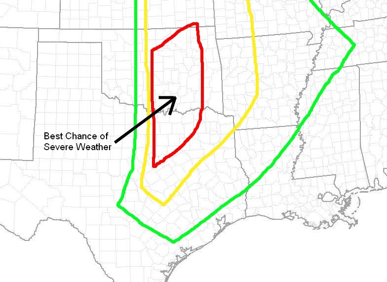
Severe Weather Possible Friday


So far the severe weather season of 2010, other than January 20th, has been very quiet. A continued intrusion of cold air over the late winter and early spring weeks have suppressed the Gulf moisture needed for strong storm development well to the south. This is about to change, at least for the end of this week. Currently we are watching a strong upper air disturbance along the Pacific Northwest coast which will move to the four corners region by Wednesday afternoon. As this system moves out of the Rockies in to the Southern Plains, a dryline will develop across west Texas and move its way towards our area. Right now it appears we will see some severe storms develop Thursday Afternoon from the Eastern Texas Panhandle south towards West Texas. These storms will move east and lose some of their strength Thursday night into Friday morning. This dryline will still be out to our west Friday afternoon giving East Texas plenty of time to warm into the lower 80s. This will set the stage for severe storms to develop out to our West late Friday afternoon and move east into East Texas Friday evening and overnight. At this time it appears there will be plenty of instability and wind shear to keep these storms at severe levels through the overnight hours. The atmosphere will be conducive for very large hail, strong gusty winds, and isolated tornadoes. Remember we are still four days away from this developing storm system and a lot could change between now and then. Severe weather outbreaks require many ingredients to come together at once. Any difference in timing could cause these storms to be weaker or stronger. Below is an outlook for severe weather on Friday. This is NOT an official forecast. The Storm Prediction Center does have most of East Texas outlooked for a 30% or greater chance of severe weather Friday. The outlook below is based on the 0Z model runs and can and probably will change between now and Friday. For those used to SPC outlooks, do NOT use the colors on this outlook to determine slight, moderate , and high risk areas. I have enhanced an area in red where I feel the greatest risk of severe weather will take place on Friday. I do believe we will see a moderate risk of severe weather issued for Friday.