Tuesday, March 29, 2011

Storms with Hail Possible Today


A developing storm system will bring a complex weather pattern to East Texas today. An area of low pressure will develop along a stalled front to our southwest. This will pull a warm front into our southern counties later this afternoon allowing scattered showers and thunderstorms to develop. South of this warm front temperatures could reach 70 degrees south of a Crockett to Hemphill line. Along and south of this line any storm that does develop could produce large hail and gusty winds.

North of this warm front across most of East Texas, temperatures will be well below normal with cloudy skies today. High temperatures will range from the middle 50s to near 60 degrees across the northern two thirds of East Texas. In this area showers and thunderstorms will develop later this afternoon above the cool air near the surface. Because these storms will develop from air above the surface, the tornado and high wind threat is very low. However, mid level temperatures are very cold allowing any storm that develops to produce hail. Most of the hail that develops today should be smaller than dime size but a few storms could produce hail larger than quarters. The farther south you go today the better the chance of seeing large hail.

The developing low pressure will move off to the northeast later this evening dragging a cold front through the area. This will bring drier air to the region tomorrow afternoon and continue to keep temperatures below normal. Another disturbance will swing through East Texas Wednesday night bringing a slight chance of showers. Most of East Texas should receive between a quarter to a half inch of rain over the next 36 hours. A few lucky spots could receive up to an inch of rain in heavier storms.

Monday, March 21, 2011

"Super Moon"


A perigee full moon occurred over the weekend making the moon appear about 14% larger than it normally does. This is an occurrence that happens about every 18 years. So if you thought the moon looked a little bigger, you were right. The above image is from my new 550D with a Tamron 28-300mm lens at 300mm. This was also shot in the 7X movie crop making my 300mm shot really 2100mm or 3360mm 35mm equivalent.

Wednesday, February 23, 2011

Strong to Severe Storms Tomorrow


A strong storm system will be moving into East Texas during the day tomorrow bringing a chance of severe thunderstorms to parts of the area. Right now it looks as though an area of low pressure will develop across northwest Texas and move into eastern Oklahoma during the afternoon. As this low moves of to the northeast a cold front will move through East Texas during the late afternoon and evening hours. This will bring the front through during the peak heating of the day giving the area more energy to fuel these storms. Most of East Texas is under a slight risk for severe storms tomorrow.
With the low pressure expected to be in eastern Oklahoma when the front moves through the area, our winds will be out of the southwest around 15 to 20 miles per hour during the day. This southwest wind will help to limit the threat of tornadoes tomorrow keeping the amount of spin available in the atmosphere much less than if the surface winds were out of the southeast.
Winds above the surface will also be out of the southwest but much faster, around 80 mph. Any thunderstorm that develops could tap into these winds bringing them down to the surface. So the threat of strong gusty winds appears to be the main threat at this time. The mid and upper levels of the atmosphere area still fairly cold meaning there will also be a threat of large hail from any storm that can develop.
This is still a developing situation and a lot could change between now and tomorrow afternoon. If the area of low pressure forecast to develop moves farther south, then our surface winds would become more favorable for tornado development. All of East Texas north of a Palestine to Nacogdoches to Center line is under a slight risk of severe storms tomorrow. Please stay tuned for the latest on this developing storm system

Monday, February 7, 2011

Another winter storm on the way


Last week’s winter weather was replaced by a very nice weekend as many areas saw temperatures soar into the 60s Sunday afternoon. A cold front moved through the area last night so today will be much colder than this past weekend but not a cold as we saw last week. Anther arctic front is heading towards East Texas late Tuesday into Wednesday morning followed by a disturbance in the upper atmosphere. It is the combination of these two events that will bring another round of wintry weather to East Texas.

With the event being 48 hours out a lot could change between now and then but based on the latest information, this is what will likely happen. Tuesday night a strong front will move through the area dropping temperatures to near or below freezing in out northern counties. Here it looks as though the precipitation will switch quickly from rain to snow. 2 to 4 inches of snow look to fall across our northern counties before this system rapidly moves out of the area.

For our central counties along and immediately south of I-20, precipitation looks to start off as rain. As the temperature falls to near freezing during the late morning hours, rain will start to freeze on elevated surfaces. As continue temperatures fall into the upper 20s by the early afternoon precipitation should transition to sleet, causing slick spots to develop on area roads. Late in the afternoon precipitation could change to snow for a couple hours allowing for 1 to 2 inches of snow to fall.

In our southern counties including the Lufkin and Nacogdoches areas, rain looks to be the primary precipitation form until late in the afternoon. During the late afternoon hours temperatures will drop below freezing allowing for rain to mix with sleet and freezing rain. Before the precipitation there could be a few flurries but little or no snow accumulation is expected at this time.

Again this forecast will likely change between now and Wednesday so please continue to stay tuned for the latest developments. A winter storm watch has been issued for our northwestern counties and more watches, advisories, or warnings could be issued tomorrow.

Wednesday, February 2, 2011

Lake Effect Snow in East Texas?

Very cold temperatures and northwest winds greeted East Texas this morning. Lows dropped down into the lower teens in many areas with wind chill values below zero. Another unusual weather phenomenon that occurred this morning was lake effect snow. Lake effect snow is very common on the leeward side of large lakes, mainly along the Great Lakes, as very cold air moves over the relatively warmer waters. However, this is very rare here in Texas. Usually the size of our man made reservoirs is not large enough to produce a lake effect. Most lakes that produce good lake effect snow have the winds traveling at least 50 miles over the water. Of course here in East Texas we have some very large reservoirs but none give the usual 50 mile long fetch of cold wind blowing across the warmer water to produce heavy snow. However, in rare cases you can get flurries or even light snow over smaller lakes and even rivers if the conditions are right.

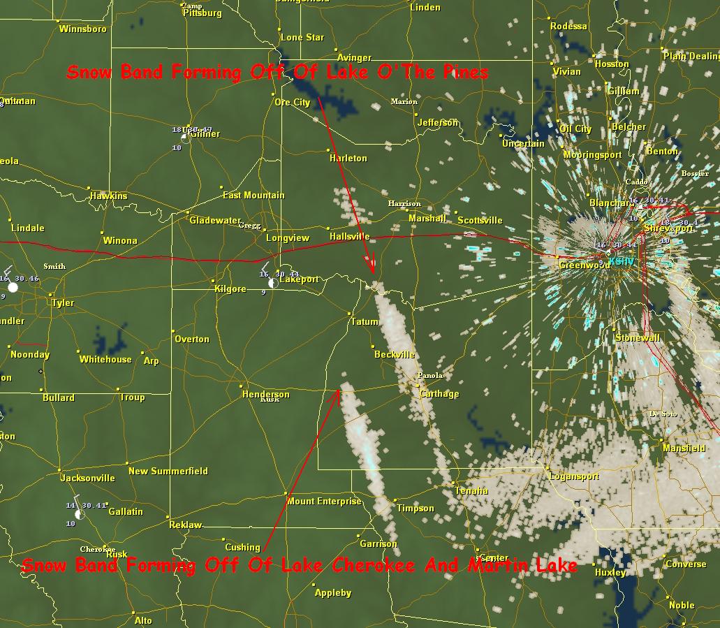
So what happened? At 4 AM most of East Texas was under clear skies except for the extreme southern counties. Our wind was out of the northwest around 15 mph moving over a deep snow pack to the north dropping our temperatures into the middle teens in most areas. Many of our East Texas lakes are oriented from northwest to southeast, parallel to the wind flow. This maximized the available moisture fetch available. Now the greatest fetch of wind over water this morning was about 20 miles. So heavy snow is not expected however, if there is a great enough difference from the water and air temperatures, moister will rise off the lake and form very low clouds, almost appearing like steam fog.

Well, this morning we had an average of 30°F difference from the lake temperature to the air temperature. This is more than enough of a difference needed to cause moisture to rise for lake effect snow. Usually you look for a difference of 13°C or about 23°F. The surface wind speed usually needed to produce a lake effect snow event is between 10 and 40 mph. Our wind speed was on the lower end which actually helps the air mass acquire the moisture needed to produce snow down wind.

This is a radar shot from the Shreveport NEXRAD that shows two snow bands that developed this morning. Both of these bands developed off of the warmer waters of nearby lakes. The other bands that developed this morning were too far away to be detected by radar but could be seen from space. Notice the cloud streaks that formed downwind from all of the area lakes this morning.

So next time you see a big weather story in Buffalo, NY showing you how many feet of snow fell remember, we here in East Texas got a little taste of what our neighbors to the north have to deal with many times a year.

Wednesday, January 12, 2011

Fellow Texas Tigers


The above photo is of my daughter Halen and me after our snow the day before the big game. Below is a photo from some fellow Texas Tigers the Gilbert family with their big Auburn snowman. If there are any other fellow Tigers that have any Auburn snow pictures please send them my way to gdade@kltv.com. Thanks and WAR EAGLE!!

Saturday, January 8, 2011

Heavy snow appears likely for parts of East Texas Sunday


A significant winter storm is forecast to develop later tonight and move into the area on Sunday. An area of low pressure in the mid and upper levels of the atmosphere is moving across the Panhandle this morning and will drop down to the Hill Country this evening before moving northeast across East Texas tomorrow afternoon. At the same time an area of low pressure at the surface will develop along the Texas Gulf coast throwing Gulf moisture across East Texas. Precipitation should begin to fall before sunrise Sunday morning but the big challenge in this forecast is, what type of precipitation. Right now based on the latest data, this is the what we are expecting.
Between 6:00AM and noon we will see a mixture of rain sleet and snow across the area. For areas along and east of a Marshal Center line we could be looking at freezing rain as well. For areas west of that line, temperatures should remain above freezing during this time period so no ice accumulations are expected.
Between Noon and 3:00PM the upper level low pressure will be moving into the area bringing much colder air above the surface. As this happens most of the precipitation north and west of a line from Marshal to Jacksonville to Palestine should begin to chance over to snow. South and east of this line a mixture of rain sleet and snow can be expected as far south as Crockett to Lufkin to Center. Areas East of the Marshal to Center line may be dealing will small ice accumulations.
Between 3:00PM and 6:00PM the upper level low should be over East Texas changing all precipitation to snow. It is during this time that significant accumulations of snow could occur along and just to the north of the low's eventual path. The best chance of seeing four or more inches of snow will be along and north of a Palestine to Jacksonville to Marshall line. If heavy snow bands develop then some parts of East Texas could see more than six inches of snow.
Between 6:00PM and Midnight the upper low will be moving East of the area. During this time accumulating snowfall should begin to end. Right now it looks as though all of East Texas could see at least 1 inch of snow north of a Crockett to Lufkin to Hemphill line with areas between I-20 and I-30 possible seeing 4 to 6 inches or more of snow.
Again, this forecast is dependent on the development of a surface low in the northern gulf and the eventual path of the upper low to our west. Please stay tuned for the latest changes in the forecast over the weekend.

Friday, January 7, 2011

Rain sleet and snow to hit East Texas Sunday

A strong storm system will develop across the northern Gulf this weekend bringing some much needed rain to East Texas. Precipitation forecast show much of the area could receive between one and two inches between Saturday night and Monday morning. At the same time this surface low is developing across the northern Gulf, and upper level low pressure will be moving into our northern counties. It is this upper level low that will provide enough cold air in the mid and upper levels for snow to develop. Right now it looks as though temperatures Sunday afternoon and evening will be in the middle 30s from I-20 north. Although this is above freezing, it is cold enough for snow to reach the surface. Based on the forecast intensity of the precipitation, it does appear some areas of East Texas could see accumulations of snow Sunday afternoon and evening. The best chance of seeing accumulating snow is over our northeastern counties, mainly along and north of a Sulphur Springs to Jefferson line. Here one to two inches of snow with locally heavier amounts could occur.
As for the Tyler Longview and Jacksonville areas, it appears right now we will mostly see a rain event mixed with sleet and snow at times late Sunday. At this time no accumulations are expected but this could change based on the eventual path of the low pressure.
In the Lufkin Nacogdoches and Crockett areas mainly a cold rain is expected. If the low pressure tracks farther south, then a mix of sleet and snow could occur. As with all winter forecast in Texas, a lot could change between now and Sunday. If the low track farther south, much of East Texas could see an accumulating snow event. If the low tracks farther north, all areas of East Texas would probably just receive rain.
Once Sunday’s storm system moves out, much colder air will move into the area. Highs by Tuesday and Wednesday still only appear to be in the 30s. A fast moving disturbance could even produce a few flurries during the mid week period but no travel problems are anticipated with this system. Please stay tuned to the latest weather information on this developing winter storm.

Wednesday, January 5, 2011

Next Week Still Looks Cold, Maybe Colder The Following Week

Arctic air is still scheduled to make its way into East Texas Next week. Right now it appears that a strong arctic front will move through the area late Monday or early Tuesday bringing the coldest temperatures of the New Year. Temperatures behind this front will more than likely remain in the 30s for highs next Wednesday and Thursday before winds begin to turn out of the southeast next Friday warming us back into the 50s. It also appears we will see a good deal of cloud cover during the middle part of next week which will actually help us out. Without the cloud cover we could easily drop into the lower teen next week during the night time hours. But thanks to the clouds, most areas will only drop into the lower to middle 20s, still cold but not quite as bad as we could be. We will also be watching a disturbance in the mid levels of the atmosphere on Wednesday. As with most arctic air masses, this one will be very dry. However, with this upper level energy a few snow flurries could be squeezed out across the area. As it looks right now no accumulation would occur thanks to the very dry air mass.

Once this first batch of cold air moves out of the area our attention will focus to the possibility of an even colder air mass moving into the area the following week. The upper air pattern is forecast on Saturday the 15th shows the jet stream surging north over Alaska and northeastern Siberia. This is typically a pattern that sends some of the coldest arctic outbreaks into the United States. This is the same pattern we saw last January that sent temperatures into the upper single digits and lower teen across East Texas. Right now it looks as though temperatures could be as low as 10 degrees in the area if what is forecast occurs.

Monday, January 3, 2011

You Think The 20s Are Cold!

From The National Weather Service Forth WorthAs we ushered in the New Year fairly cold temperatures greeted us this morning. Some of our East Central locations dropped to near 20 degrees this morning. But, if the long term forecast models we use to peek into the future are right, 20 degrees could feel balmy by the middle of January. It appears the upper level wind pattern will become favorable for an arctic outbreak to invade the country during the second and third week of January as the jet stream will surge north into northern Alaska and then plunge south across the continental United States. This is the same upper air pattern that tapped very cold air from the Arctic bringing the coldest air in over ten years to East Texas last January.

Now a lot can change between now and then with this forecast being over 10 days out but, right now it looks as though two chunks of arctic air will invade the country; one around the 10th and the second around the 17th of January. The first air mass appears to be much below normal and if it does move into East Texas we would see lows in the teens and highs in the 30s. This is not quite as could as last January but it is well below normal.

The second chunk of arctic air is being advertised right now as some of the coldest air seen in years. If, and this is a big if, this does occur, this could very well be the coldest air mass parts of the country has seen this new Millennium. The current forecast surface temperatures for Monday morning the 17th place the 0 degree line south of I-20 meaning much of East Texas would be below zero.
This would smash records for that date which are in the lower and middle teens and would come close to setting all time record lows for January.

Now with that said, I seriously doubt we will see temperatures as cold as advertised. We typically see long range forecast models producing extremely cold air this far out. I will say I have not seen it advertised this cold before this far south. Before we hit the lower teens in most areas last January our long range forecast models were advertising temperatures dropping to near zero. So based on what happened last year it is logical to think temperatures between 8 and 12 degrees could occur with this outbreak.

Again, this all depends on the eventual placement of the jet stream. If the upper air pattern changes, the cold air could be forced farther east and miss our area of the country. Or it could remain locked in Canada. Only time will tell. But based on the information available to us right now, it does appear some very cold air will move into the area the second and third week of this month. Stay tuned!

Wednesday, December 1, 2010

Atlanta, LA EF-4 Tornado

Monday afternoon strong to severe storms developed over East Texas and West Louisiana as a cold front moved across the area. As we see many times this during cool season severe weather events, this situation involved a low instability high shear environment. The storm that produced the EF-4 tornado developed in the Toledo Bend area of East Texas early Monday afternoon south of Hemphill in an area of MLCAPE just under 1000 J/kg.
You combine this with 0-6km bulk shear around 40 knots, and the atmosphere was set for the possibility of supercells thunderstorms. As the storm moved to the northeast it entered an area where MLCAPE was approaching 750 J/kg, not overly impressive when one thinks of tornadic supercells. However, when you look at the surface based lifter index you will see the values are around -4°C,
which shows a decent amount of instability, more than likely produce what is called short fat CAPE. This would allow for strong updrafts to form in the lower level of the atmosphere where the overall shear was very high. 0-1km shear was on the order of 40-45 knots near Atlanta one hour before the tornado was produced.
At the same time the 0-1km Storm Relative Helicity was over 400 in southwestern Winn Parish.
At 2:46PM the circulation associated with the developing tornado was about 5 miles south of Natchitoches, LA moving into the area of 400+ 0-1km SRH. 20 Minutes later the circulation was very intense just to the west of Atlanta, 4 minutes before the tornado touched down. Shortly after touching down, this tornado destroyed a well built brick home causing EF-4 damage.

Another interesting observation is the decrease in the vertical intensity of the reflectivity values before the tornado was produced. The storm was at its most intense, at least by the depth of reflectivity, 10 minutes before the tightest velocity couplet occurred. At this time 60dbz reflectivity was nearing 30,000 feet in the atmosphere.
At the time of the strongest velocity couplet the height of the 60dbz reflectivity was nearly cut in half, just reaching above 15,000 feet in the atmosphere. Could this collapse help in the sudden intensification of the tornado to EF-4 strength where winds were estimated to have reached 170MPH for a short path?Studies have shown in the past that supercell mesocylones have strengthened after a weakening phase in overall vertical thunderstorm strength. It is interesting to see the short path of the EF3 to EF4 damage with this storm and that it occurred after this decrease in intensification.

The tornado finally dissipated just northwest of Winnfield for a path length of 14 miles. Later, this same thunderstorm would produce another tornado rated EF-1 near Bosco before moving into Mississippi.

Tuesday, November 30, 2010

Sleet and Snow at 45 Degrees?


A cold front moved through the area yesterday ushering in cooler and drier air to East Texas. Behind the front precipitation developed in the colder air in the form of snow around 12,000 feet in the atmosphere. As this snow fell towards the surface, most of it evaporated not reaching the surface. However, in a few areas where the precipitation was heavy enough, light rain and sleet did make it to the surface mixed at times with a few snowflakes. So how is it possible for sleet and snow to reach the ground when the surface temperature is well above freezing, in the middle 40s?

Well, you have to look at the temperature and moisture content of the entire atmosphere to see if sleet and snow will reach the surface, not just the surface temperature. By looking a forecast sounding from Tyler this morning, or a profile of the atmosphere, precipitation was developing in an area where the temperature was between -10°C and -20°C, the perfect temperature for snow crystal growth. As the snow fell from the clouds it entered a layer of the atmosphere that was very dry allowing most of the precipitation to evaporate. However, in areas where the precipitation was heavy enough, a few flakes remained. Once the snow reached around the 5000’ mark in elevation it entered an area where the temperature was slightly above freezing. So much of the remaining snow partially melted in this layer only to refreeze, in the form of sleet, as it entered below freezing temperatures again around 4000’ in elevation.

Now according to the forecast sounding for Tyler the depth of above freezing temperatures from the surface was about 1900’, usually enough to melt the sleet and snow before reaching the surface. But another temperature that is very important in winter weather forecasting in the wetbulb temperature or the temperature that would be reached when evaporation occurs. The depth of the above freezing wetbulb temperature this morning was only around 800’. So in areas of more intense precipitation this morning, the process of evaporational cooling would bring temperatures to the wetbulb level allowing sleet and snow to reach the surface. I must say I expected a little light sleet this morning, like we saw last Friday. But I was very surprised to see a few snowflakes hitting the wind shield this morning until I analyzed the forecast sounding. There always seems to be something exciting in the world of weather.

Friday, November 19, 2010

A Cold Thanksgiving?

An arctic air mass is building in Northern Canada and looks to move south into the United States next week. Temperatures this morning were as low as -35°F in Canada and this air mass will slowly drift south the next few days. By Wednesday Morning temperatures look to be between -10°F and -20°F across Montana and the Dakotas. Wed 6AM Temps
As this air mass moves south, it will moderate considerable due to the lack of snow cover across the country. But it still should be the coldest air we have seen this year across East Texas. How cold? Well we could be looking at temperatures falling through the 40s on Thanksgiving Day and bottoming out in the 20s by Friday Morning. So “Black Friday” looks to be mighty cold for all the shoppers looking for a good deal.6PM Thanksgiving Temps
Of course this is all a few days out and a lot could change between now and then. The biggest challenge with this forecast is the fact the upper level winds will be parallel to the front as it moves across the Plains. This sometimes can slow down or even stall the frontal passage. However, arctic area is very shallow and dense and usually will slide under the upper level winds. So right now I really don’t see anything stopping this air mass from making it our way.
Another interesting aspect of this forecast is the potential for an over running precipitation event. Right now the forecast looks dry behind the front but, with the upper level wind out of the west southwest, Pacific moisture could lift over the cooler air at the surface. Normally this causes clouds and rain to develop. This is also how we usually see our icy events in East Texas but this air mass does not look as though it will be cold enough. At the same time Pacific air could be lifting over the colder Canadian air, East Texas will be in a favorable area for lift, in the right rear section of a jet streak. You combine this with an upper air disturbance that is forecast to move into the area on Thanksgiving we could be looking at a cloudy day which would make our high temperature much colder with a few scattered showers.
Again, we are still a few days out from this frontal passage and a lot can change between now and then. Our official forecast for Thanksgiving is for partly cloudy skies and high temperatures in the middle 50s. But don’t be surprised if this forecast changes and is colder by the time we get into next week and have a better grasp on what this arctic air mass will do.

Thursday, November 11, 2010

A Narrow Opportunity for Severe Weather Tomorrow


Severe storms are possible tomorrow across northern Texas and central Oklahoma ahead of a very strong 500mb vort max moves across the Texas Panhandle into western Oklahoma Friday evening. Even though low level instability will be much lower than usual for severe thunderstorm development, the dynamics of this system appear to be enough to overcome this limitation. All the following forecast information is based off the 11/11/10 12Z NAM.
Right now SBCAPE is forecast to be between 500 and 700 J/kg for a narrow window of time Friday afternoon, with nearly 100 J/kg in the lowest 3KM of the atmosphere. If any additional daytime heating can occur, SBCAPE could reach 1000 J/kg in a few areas.

In addition to the available instability, 0-6km shear will me more than ample for supercell development. Shear values will be close to 50 knots over the greatest axis of instability which could promote robust rotating updrafts. Also, the shear vectors will remain perpendicular across the boundary of storm development so look for to develop in a non-linear form making supercells a likely storm mode

As for the tornado threat, 0-1km SRH is over 200 for a few hours ahead of the cold front so any storm that can develop in this environment could produce enough low level rotation. This along with 0-1km shear values over 20 knots should be enough to allow an isolated tornado or two to develop if storms can initiate ahead of the cold front.

Right now the SPC has a 5% chance of severe weather in this area with a mention of a supercell or two. I do believe that if the forecast trend the NAM is indicating continues a slight risk will be issued, maybe as early as the next day 2 outlook.

Thursday, October 28, 2010

5 Tornadoes Confirmed Across East Texas on Sunday


This past weekend saw an onslaught of severe weather across East Texas. Numerous reports of large hail and high winds were reported along with sightings of funnel clouds and possible tornadoes. The National Weather Service has confirmed 5 tornado paths across East Texas from Sunday afternoon and evening.
The first tornado touched down around 3:30 PM 4 miles northeast of Daingerfield along county road 4105. This tornado was on the ground for 3 miles and was approximately 75 yards wide and rated an EF-0. The images below show the storm at the time of this tornado.

The second tornado touched down around 6:00 PM in near Lone Oak close to the Hunt/Rains county line. This was a very short lived tornado on the ground for only 200 yards and approximately 50 yards wide. Ten homes received some sort of damage in the Rolling Hills Community. This tornado was also rated an EF-0. The images below show the storm at the time of this tornado.

The third tornado touched down around 6:15 PM north of Mt. Vernon near Highway 37 and county road 1030. This was a very short lived tornado as well with a path length of only a quarter of a mile and a width of 50 yards. This tornado was also rated an EF-0. The images below show the storm at the time of this tornado..
The fourth tornado touched down around 6:47 PM west of Omaha in Morris County along Highway 67 and county road 3325. This tornado was on the ground for three quarters of a mile and was 75 yards wide and was also rated an EF-0. The images below show the storm at the time of this tornado

The fifth tornado from Sunday touched down around 6:54 PM in Wood County 7 miles northwest of Mineola and was also rated an EF-0. The tornado touched down near the intersection of Highway 69 and FM 779. This tornado was on the ground for nearly 2 miles and mainly caused damage to trees. The images below show the storm at the time of this tornado.
Thankfully most of the tornadoes from Sunday caused very little damage, touching down mainly in no populated forested areas. Doppler radar showed strong rotation with many storms throughout the day. Even though large damaging tornadoes did not touch down, very large hail caused a great deal of damage throughout East Texas.

Wednesday, October 27, 2010

New Record Set for Lowest Pressure


A new record for the lowest pressure ever measured on the U.S. Mainland from a non-tropical system was set yesterday as a massive low pressure moved across the Upper Midwest. The pressure dropped to 954.95 mb or 28.20” of mercury in Big Fork, MN. This beats the previous record of 958 mb or 28.28” of mercury during the Blizzard of 1978. To put this number in prospective, this low pressure is about the same you would find in a land falling category 3 hurricane. Hurricane Ike had a pressure of 950 mb or 28.05” of mercury. Now this record is preliminary until all the data can be measured. One thing is for certain, this system was a tremendous wind and severe weather producer. Wind gusts over 70 mph were common near the low pressure and a strong line of severe storms raced across the Ohio and Tennessee river valley causing tornadoes and wide spread wind damage.

Monday, October 11, 2010

Severe storms possible today


There is a slight chance of severe weather across East Texas today. A cold front out to our west will move into the area later today and will provide enough lift for a few scattered thunderstorms to develop. Any storm that does develop could produce hail to the size of quarters and gusty winds possibly as high as 60 mph. The overall threat does not appear to be very high at this time however I do expect a couple of severe weather reports before the day is through.
Much of East Texas remains under burning bans today due to the dry conditions. The good news today is our relative humidity will be much higher than we have seen across East Texas. This means the fire danger is not as high today however, it is still not recommended to do any outdoor burning.
Although we will see a few scattered storms across East Texas today, most areas will more than likely remain dry so burning bans will remain in effect for much of the area. As we head towards next week another cold front is forecast to move into the area. This front may be able to produce more widespread rain so until then, look for dry conditions to continue in most areas.