Wednesday, July 27, 2011
Come on Don!
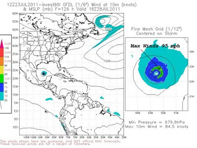
Yesterday we brought to everyone’s attention there could be a tropical system developing near Cuba. The National Hurricane center had this area under a slight risk of developing but we mentioned the system looked fairly organized and was worth monitoring closely. This morning it is now looking likely this system will develop into a tropical depression later today and possibly Tropical Storm Don. The National Hurricane Center now has this area under a high likelihood of development and is sending an air force hurricane hunter to investigate. Once the plane reaches this system I have a good feeling it will be classified as a depression.
Now for the good news. It appears the timing of this system along with the eastward movement of our strong high pressure that has been baking us all summer, will allow for lots of tropical moisture to invade the area. So even if what could become Don moves to our south, the chances of seeing afternoon thunderstorms will increase greatly Friday and Saturday and should bring an end to the steak of 100 degree days.
It is not all good news however. If this system moves farther north that could put East Texas in the area we would need to monitor for weak tornadoes that occur with land falling tropical systems. Also, with the extremely dry ground, rapid run off could occur with very heavy downpours giving parts of East Texas a threat of flash flooding.
We will continue to monitor this system over the next few days. I for one could deal with a little severe weather if it means rain and an end to the extreme heat. One thing is for sure. If we do not get a decent amount of rain with this system, next week will be very hot with highs approaching 105 degrees again as our friendly high pressure ridge builds back in.
Tuesday, July 26, 2011
Could Don be out There?
Tropical forecast models were hinting at a developing tropical system a couple of days ago. Some of the high resolution models were showing a strong tropical storm or hurricane by Friday morning. If this were to happen the storm’s name would be Don. Right now the models have backed off on this development but it will be interesting to watch. It seems as though this disturbance has become a little better organized the past 24 hours. This could be just what East Texas needs, a tropical system moving to our south but close enough to send in lots of tropical moisture increasing our chance of rain. If this system takes a more northerly track we could see locally heavy rain over the weekend.
If it moves farther south, East Texas would be mostly dry and very hot. Right now it appears the second scenario is more likely but we will continue to watch this developing system.
Monday, July 18, 2011
I'll Hold at 20 but................
20 days. That is where Tyler stands right now on the record setting number of days at or above 100 degrees. This ties the record for any reporting station in Tyler reporting 100 degrees or more in a row. The previous record ended in August of 1998 when Tyler had a run 20 days. That same year Longview had 21 days in a row at or above 100 degrees. Right now Tyler and Longview are both holding with 20 and 18 days respectfully. However it looks as though the dealer may not be done and both cities could bust in respect to the 21 you want in Black Jack. What is the next card to be dealt? We will have to see. But there is a chance the dealer is holding a 7 which would give Tyler a 27 and Longview a 25, both big busts!
Tuesday, July 12, 2011
Crazy From The Heat Records
Yesterday was another day with temperatures above 100°F making it the 14th straight day in Tyler and the 12th straight day in Longview. The only thing crazier than the heat in my opinion is trying to keep up with all the heat records for East Texas. Yesterday I stated that the longest stretch on record for Tyler was 16 days in 1980 and the longest stretch of days for Longview was 10 days in 2006. Well, that is not entirely true and it starts to get real confusing. So I will try to straighten up all the confusion today, remember I said try.
The problem with weather records here in East Texas is the “official” site has changed many times throughout the years and is actually pretty hard to find when doing research. The “official” weather observation site for Tyler has been at the Tyler Pounds Airport since May of 2000. In Longview the “official” site has been at the East Texas Regional Airport since February of 2001 but since the National Weather Service used to be stationed in Longview, there have been reports from the airport since the mid 70s.
There are also many other “unofficial” sites that have kept data over the past 100 years or so. One of those sites showed Tyler had a stretch of 16 days above 100 degrees in 1980 however; the “official” site the Weather Service uses shows only 12 straight days above 100 degrees. Confused yet? So am I.
Well, after a lot of research my friend from the Nation Weather Service in Shreveport Jason Hansford has given me an “official” record that they will be using for the longest stretch of 100 degree plus days for Tyler and Longview. The year was 1998 with Tyler going 20 days and Longview going 21 days at or above 100°F. But remember, these readings were from different locations than we use today. The 21 days for Longview actually occurred 11 miles to the southeast of Longview and not at the airport. The airport only recorded 12 days in a row that year.
So unless we see the triple digit heat linger into the first part of next week, the “official” records appear to be safe. However, since the ASOS (Automated Surface Observing System) has been commissioned in both Tyler and Longview, this stretch of 100°F plus days is the longest.
Monday, July 11, 2011
When Will It End?
For much of East Texas June was the hottest June on record and July is starting off much the same way. If the forecast high temperatures are reached today across East Texas it will make the 14th straight day that Tyler as hit or surpassed 100°F. This is the second longest stretch of 100°F plus days on record. The longest on record is 16 days in 1980. Today would be the 12th straight day of 100°F heat in Longview, the longest stretch on record. So why has it been so hot?
Well, if you can think back to April when we first started to see the mercury hit the 90°F mark, we began to mention if we do not see a significant amount of rain we were in for a very hot summer. The reason for this is because of how dry our soil is here in East Texas. As the sun shines down on the Earth’s surface, much of its energy is used to evaporate soil moisture causing the ground to remain relatively cool. This year we have seen soil moisture extremely low across East Texas. When this happens all of the sun’s energy can be used to heat the ground which in turn heats the air. The hotter the soil temperature, the hotter the air will become. For the majority of East Texas the soil moisture is less than 5% of what it normally should be for this time of the year. On Saturday the 10th the soil moisture for much of East Texas was actually less than 1% of what we normally see. (The dark red shading across the southern 2/3rds of East Texas indicate less than 1% of normal soil moisture)
This is not good for the hopes of seeing cooler temperatures anytime soon. Even if we are able to see afternoon and evening thunderstorms develop, the amount of aerial coverage will not be enough to cause an increase in soil moisture to bring temperatures back to a normal level. East Texas’ climate this year is becoming more like what you would find across west Texas where dry soil leads to 100°F quite often. The only real hope we have of seeing a significant increase in soil moisture is if a tropical system moves into our area bringing widespread 3 to 5 inches of rain.
Hopefully this will happen. The Atlantic Hurricane seasonal forecast is above normal this year. Of course we do not need a tropical storm or hurricane to cause a significant amount of damage to the area. What we need is a tropical depression to move into the area and stay for a day or two providing widespread heavy rain. This would give us the average amount of soil moisture we usually see giving us average temperatures instead of well above temperatures. If we do not see this we may set all time record high temperatures across East Texas this summer. In Tyler we hit 105°F in June tying the all time record for the month. The all time record high for Tyler is 111°F and for Longview is 113°F. As many tell me, “This is summer in East Texas. It’s supposed to be hot!” Well not this hot. But don’t worry. We are only 91 days away from our average highs being in the upper 70s, and it can’t get here soon enough.
Friday, July 8, 2011
Wednesday, July 6, 2011
Bolt From The Blue
Tuesday, July 5, 2011
Man and Mother Nature on the Fourth
This was shot last night from my back yard. It was a 20 second exposure @ f/8 at on my Sigma 8-16mm UWA lens at 8mm cropped to show the lightning and fireworks together. This is on the overall left side of the image which is a little soft. Also, the gusty winds blowing the fireworks west add to the blur just a bit. Overall, I am happy with the shot.
Friday, July 1, 2011
Gilmer Micro-Burst in 3D
Last evening's storms that popped across East Texas produced scattered high wind and hail reports as they drifted across the area. The Storm in Gilmer was fairly stationary as the updraft grew just to the north of town.
In the image below the storm is nearing its mature state. Notice the dark reddish purple core reaching nearly 30,000 feet into the atmosphere. It is at this time that the storm is developing its hail core and soon produce quarter size hail in Gilmer.
The next image below shows the storm at its mature stage. Notice how large the reddish purple color is and how high the light blue overshooting top is, reaching 55,000 feet in the atmosphere. The image below was taken at 6:24 PM about 10 minutes before it would unleash its severity.
In the next image notice the overshooting top has disappeared. This is the beginning of the collapse of this large storm. The time here is 6:29PM.
The next image shows the hail core is much smaller. This tells us the hail the storm was holding aloft is now reaching the ground. Shortly after this image quarter size hail was reported in Gilmer.
The next image shows the core is not only shorter, much much skinnier as well. Most of the hail at this point is falling or has fallen out of the storm. At this time the very strong downburst winds are hitting the ground as well.
The final image shows the storm in its decaying stage. The strong downburst has caused damage to parts of the downtown area of Gilmer. It has also cut off the updraft to the storm causing this storm to end but sending an outflow boundary south which will give birth to new storms.
There were two other severe micro-bursts across East Texas Thursday evening. All showed similar appearance on radar. Anytime we have surface temperatures around 100 degrees, any storm that develops could produce very strong winds. We will be watching the radar closely to see if we see a repeat tonight.
Subscribe to:
Posts (Atom)