Wednesday, December 1, 2010

Atlanta, LA EF-4 Tornado

Monday afternoon strong to severe storms developed over East Texas and West Louisiana as a cold front moved across the area. As we see many times this during cool season severe weather events, this situation involved a low instability high shear environment. The storm that produced the EF-4 tornado developed in the Toledo Bend area of East Texas early Monday afternoon south of Hemphill in an area of MLCAPE just under 1000 J/kg.
You combine this with 0-6km bulk shear around 40 knots, and the atmosphere was set for the possibility of supercells thunderstorms. As the storm moved to the northeast it entered an area where MLCAPE was approaching 750 J/kg, not overly impressive when one thinks of tornadic supercells. However, when you look at the surface based lifter index you will see the values are around -4°C,
which shows a decent amount of instability, more than likely produce what is called short fat CAPE. This would allow for strong updrafts to form in the lower level of the atmosphere where the overall shear was very high. 0-1km shear was on the order of 40-45 knots near Atlanta one hour before the tornado was produced.
At the same time the 0-1km Storm Relative Helicity was over 400 in southwestern Winn Parish.
At 2:46PM the circulation associated with the developing tornado was about 5 miles south of Natchitoches, LA moving into the area of 400+ 0-1km SRH. 20 Minutes later the circulation was very intense just to the west of Atlanta, 4 minutes before the tornado touched down. Shortly after touching down, this tornado destroyed a well built brick home causing EF-4 damage.

Another interesting observation is the decrease in the vertical intensity of the reflectivity values before the tornado was produced. The storm was at its most intense, at least by the depth of reflectivity, 10 minutes before the tightest velocity couplet occurred. At this time 60dbz reflectivity was nearing 30,000 feet in the atmosphere.
At the time of the strongest velocity couplet the height of the 60dbz reflectivity was nearly cut in half, just reaching above 15,000 feet in the atmosphere. Could this collapse help in the sudden intensification of the tornado to EF-4 strength where winds were estimated to have reached 170MPH for a short path?Studies have shown in the past that supercell mesocylones have strengthened after a weakening phase in overall vertical thunderstorm strength. It is interesting to see the short path of the EF3 to EF4 damage with this storm and that it occurred after this decrease in intensification.

The tornado finally dissipated just northwest of Winnfield for a path length of 14 miles. Later, this same thunderstorm would produce another tornado rated EF-1 near Bosco before moving into Mississippi.

Tuesday, November 30, 2010

Sleet and Snow at 45 Degrees?


A cold front moved through the area yesterday ushering in cooler and drier air to East Texas. Behind the front precipitation developed in the colder air in the form of snow around 12,000 feet in the atmosphere. As this snow fell towards the surface, most of it evaporated not reaching the surface. However, in a few areas where the precipitation was heavy enough, light rain and sleet did make it to the surface mixed at times with a few snowflakes. So how is it possible for sleet and snow to reach the ground when the surface temperature is well above freezing, in the middle 40s?

Well, you have to look at the temperature and moisture content of the entire atmosphere to see if sleet and snow will reach the surface, not just the surface temperature. By looking a forecast sounding from Tyler this morning, or a profile of the atmosphere, precipitation was developing in an area where the temperature was between -10°C and -20°C, the perfect temperature for snow crystal growth. As the snow fell from the clouds it entered a layer of the atmosphere that was very dry allowing most of the precipitation to evaporate. However, in areas where the precipitation was heavy enough, a few flakes remained. Once the snow reached around the 5000’ mark in elevation it entered an area where the temperature was slightly above freezing. So much of the remaining snow partially melted in this layer only to refreeze, in the form of sleet, as it entered below freezing temperatures again around 4000’ in elevation.

Now according to the forecast sounding for Tyler the depth of above freezing temperatures from the surface was about 1900’, usually enough to melt the sleet and snow before reaching the surface. But another temperature that is very important in winter weather forecasting in the wetbulb temperature or the temperature that would be reached when evaporation occurs. The depth of the above freezing wetbulb temperature this morning was only around 800’. So in areas of more intense precipitation this morning, the process of evaporational cooling would bring temperatures to the wetbulb level allowing sleet and snow to reach the surface. I must say I expected a little light sleet this morning, like we saw last Friday. But I was very surprised to see a few snowflakes hitting the wind shield this morning until I analyzed the forecast sounding. There always seems to be something exciting in the world of weather.

Friday, November 19, 2010

A Cold Thanksgiving?

An arctic air mass is building in Northern Canada and looks to move south into the United States next week. Temperatures this morning were as low as -35°F in Canada and this air mass will slowly drift south the next few days. By Wednesday Morning temperatures look to be between -10°F and -20°F across Montana and the Dakotas. Wed 6AM Temps
As this air mass moves south, it will moderate considerable due to the lack of snow cover across the country. But it still should be the coldest air we have seen this year across East Texas. How cold? Well we could be looking at temperatures falling through the 40s on Thanksgiving Day and bottoming out in the 20s by Friday Morning. So “Black Friday” looks to be mighty cold for all the shoppers looking for a good deal.6PM Thanksgiving Temps
Of course this is all a few days out and a lot could change between now and then. The biggest challenge with this forecast is the fact the upper level winds will be parallel to the front as it moves across the Plains. This sometimes can slow down or even stall the frontal passage. However, arctic area is very shallow and dense and usually will slide under the upper level winds. So right now I really don’t see anything stopping this air mass from making it our way.
Another interesting aspect of this forecast is the potential for an over running precipitation event. Right now the forecast looks dry behind the front but, with the upper level wind out of the west southwest, Pacific moisture could lift over the cooler air at the surface. Normally this causes clouds and rain to develop. This is also how we usually see our icy events in East Texas but this air mass does not look as though it will be cold enough. At the same time Pacific air could be lifting over the colder Canadian air, East Texas will be in a favorable area for lift, in the right rear section of a jet streak. You combine this with an upper air disturbance that is forecast to move into the area on Thanksgiving we could be looking at a cloudy day which would make our high temperature much colder with a few scattered showers.
Again, we are still a few days out from this frontal passage and a lot can change between now and then. Our official forecast for Thanksgiving is for partly cloudy skies and high temperatures in the middle 50s. But don’t be surprised if this forecast changes and is colder by the time we get into next week and have a better grasp on what this arctic air mass will do.

Thursday, November 11, 2010

A Narrow Opportunity for Severe Weather Tomorrow


Severe storms are possible tomorrow across northern Texas and central Oklahoma ahead of a very strong 500mb vort max moves across the Texas Panhandle into western Oklahoma Friday evening. Even though low level instability will be much lower than usual for severe thunderstorm development, the dynamics of this system appear to be enough to overcome this limitation. All the following forecast information is based off the 11/11/10 12Z NAM.
Right now SBCAPE is forecast to be between 500 and 700 J/kg for a narrow window of time Friday afternoon, with nearly 100 J/kg in the lowest 3KM of the atmosphere. If any additional daytime heating can occur, SBCAPE could reach 1000 J/kg in a few areas.

In addition to the available instability, 0-6km shear will me more than ample for supercell development. Shear values will be close to 50 knots over the greatest axis of instability which could promote robust rotating updrafts. Also, the shear vectors will remain perpendicular across the boundary of storm development so look for to develop in a non-linear form making supercells a likely storm mode

As for the tornado threat, 0-1km SRH is over 200 for a few hours ahead of the cold front so any storm that can develop in this environment could produce enough low level rotation. This along with 0-1km shear values over 20 knots should be enough to allow an isolated tornado or two to develop if storms can initiate ahead of the cold front.

Right now the SPC has a 5% chance of severe weather in this area with a mention of a supercell or two. I do believe that if the forecast trend the NAM is indicating continues a slight risk will be issued, maybe as early as the next day 2 outlook.

Thursday, October 28, 2010

5 Tornadoes Confirmed Across East Texas on Sunday


This past weekend saw an onslaught of severe weather across East Texas. Numerous reports of large hail and high winds were reported along with sightings of funnel clouds and possible tornadoes. The National Weather Service has confirmed 5 tornado paths across East Texas from Sunday afternoon and evening.
The first tornado touched down around 3:30 PM 4 miles northeast of Daingerfield along county road 4105. This tornado was on the ground for 3 miles and was approximately 75 yards wide and rated an EF-0. The images below show the storm at the time of this tornado.

The second tornado touched down around 6:00 PM in near Lone Oak close to the Hunt/Rains county line. This was a very short lived tornado on the ground for only 200 yards and approximately 50 yards wide. Ten homes received some sort of damage in the Rolling Hills Community. This tornado was also rated an EF-0. The images below show the storm at the time of this tornado.

The third tornado touched down around 6:15 PM north of Mt. Vernon near Highway 37 and county road 1030. This was a very short lived tornado as well with a path length of only a quarter of a mile and a width of 50 yards. This tornado was also rated an EF-0. The images below show the storm at the time of this tornado..
The fourth tornado touched down around 6:47 PM west of Omaha in Morris County along Highway 67 and county road 3325. This tornado was on the ground for three quarters of a mile and was 75 yards wide and was also rated an EF-0. The images below show the storm at the time of this tornado

The fifth tornado from Sunday touched down around 6:54 PM in Wood County 7 miles northwest of Mineola and was also rated an EF-0. The tornado touched down near the intersection of Highway 69 and FM 779. This tornado was on the ground for nearly 2 miles and mainly caused damage to trees. The images below show the storm at the time of this tornado.
Thankfully most of the tornadoes from Sunday caused very little damage, touching down mainly in no populated forested areas. Doppler radar showed strong rotation with many storms throughout the day. Even though large damaging tornadoes did not touch down, very large hail caused a great deal of damage throughout East Texas.

Wednesday, October 27, 2010

New Record Set for Lowest Pressure


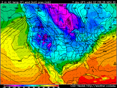
A new record for the lowest pressure ever measured on the U.S. Mainland from a non-tropical system was set yesterday as a massive low pressure moved across the Upper Midwest. The pressure dropped to 954.95 mb or 28.20” of mercury in Big Fork, MN. This beats the previous record of 958 mb or 28.28” of mercury during the Blizzard of 1978. To put this number in prospective, this low pressure is about the same you would find in a land falling category 3 hurricane. Hurricane Ike had a pressure of 950 mb or 28.05” of mercury. Now this record is preliminary until all the data can be measured. One thing is for certain, this system was a tremendous wind and severe weather producer. Wind gusts over 70 mph were common near the low pressure and a strong line of severe storms raced across the Ohio and Tennessee river valley causing tornadoes and wide spread wind damage.

Monday, October 11, 2010

Severe storms possible today


There is a slight chance of severe weather across East Texas today. A cold front out to our west will move into the area later today and will provide enough lift for a few scattered thunderstorms to develop. Any storm that does develop could produce hail to the size of quarters and gusty winds possibly as high as 60 mph. The overall threat does not appear to be very high at this time however I do expect a couple of severe weather reports before the day is through.
Much of East Texas remains under burning bans today due to the dry conditions. The good news today is our relative humidity will be much higher than we have seen across East Texas. This means the fire danger is not as high today however, it is still not recommended to do any outdoor burning.
Although we will see a few scattered storms across East Texas today, most areas will more than likely remain dry so burning bans will remain in effect for much of the area. As we head towards next week another cold front is forecast to move into the area. This front may be able to produce more widespread rain so until then, look for dry conditions to continue in most areas.

Monday, September 13, 2010

Igor Could Become a Cat 5 Storm!


Hurricane Igor continues to strengthen as he moves across the Atlantic. It now appears Igor could become a rare category 5 hurricane later today as top winds could peak above 160 mph. The high resolution visible satellite image above shows Igor having a well defined eye with bright white clouds surrounding the center of the storm. This indicates Igor’s eye is surrounded by very tall thunderstorms or deep convection as we like to say in the weather world. The image below gives us an enhanced look by adding colors to the cloud tops. The colder temperatures are indicated by the orange and red colors. Notice the red nearly making a circle around the eye indicated very tall clouds and a healthy eye wall.

So where will Igor go? Thankfully for the United States Atlantic Coast it appears a blocking high pressure will keep Igor out to sea. Most computer models send Igor and the weaker storm to follow Julia out in the central Atlantic. However, we will need to monitor the stronger high that is located southwest of Great Britain. There are a few models that weaken the High over the U.S. and strengthen the high over the eastern Atlantic. If this does happen Igor could be pushed to the west towards the New England coast. In the aforementioned scenario, Igor could make landfall near New York City as a category 2 or 3 storm but at this time this seems highly unlikely.

We are monitoring another area of disturbed weather south of Cuba. This tropical disturbance could become a depression over the next couple of days. Right now it appears this system will move west and hit the Yucatán Peninsula continuing west into Central Mexico. This last system has the best chance of any to make it to the U.S. Mainland so we will continue to watch it closely.

Thursday, August 12, 2010

Major Snow Storm...Six Months ago!

What a difference 6 months makes. Six months ago today all of East Texas awoke to one of the greatest snowfalls in East Texas history. Snowfall amounts ranged from just over an inch in the Lufkin area to a foot of snow in Canton. Other substantial amounts were 8” in Athens, 6” in Tyler, and 7” in Longview. The winter of 2009-2010 was a much colder winter than we usually see in these parts thanks to a fairly stagnant weather patter allowing cold air outbreaks to surge into East Texas throughout the winter months. An accumulating snow even occurred on the first day of spring in East Texas. So after such a cold winter, why has our summer been so hot? Well, we once again are in a stagnant weather pattern keeping a strong ridge of high pressure over East Texas. This area of high pressure has allowed high temperatures to remain near the century mark for nearly 10 days.

Now this heat has been extreme but it has not been record setting. High temperatures have remained about 5 degrees cooler than record high temperatures and we can expect this trend to continue. So yes it has been a very hot summer, especially late July until now, but it has been much worse. The summers of 1921, 1936, 1939, 1980, and 1998 all and numerous consecutive days with record high heat. When will it end? I know the funny and trendy answer here is to say October but, we usually see a fairly significant Canadian air mass move into the area during September. Temperatures in northern Canada and northern Alaska have been cooling down rapidly and we have even seen some snow in these areas. A strong area of low pressure will send some of this air south next week but by the time it reaches the lower 48, the air mass will modify greatly. So I know it seems as though this heat will never end but trust me, in a few weeks it will just be a memory, like our historic snow earlier this year.

Wednesday, July 28, 2010

South Dakota May Have Set a New Record for Hail Size


A new weather record for the United States could have been set last week in South Dakota. A hailstone that appears to be 8” in diameter fell in Vivian, South Dakota FridayVivian, SD Hailstone
afternoon and this would break the record of 7” with fell in Aurora, Nebraska in 2003. Aurora, NE HailstoneForecasters from the National Weather Service out of Aberdeen, SD will make the drive to Vivian to see if the hailstone officially will break the record. Damage reports range from busted car windows to holes punched through the rooves of houses, even reports of large hail landing on the floor of one resident’s living room.

But the 8” stone may not have been the largest from this day. According to the Rapid City Journal one resident of Vivian, Punk Strom, found a stone that had been outside for over and hour and a half and still weighed 1.8 pounds when he weighed it at the Vivian post office. This would break the record for heaviest hailstone in the United States of 1.6 pounds which fell in Coffeyville, KS in 1970. We should know later today whether or not this hailstone sets a new record for the United States.

Thursday, July 22, 2010

Bonnie Brewing.....


A new tropical depression has formed southeast of Miami, FL and could become Bonnie as early as this evening. This system has been struggling to develop over the past couple of days due to an upper level low pressure just east of the surface low. This upper low has been shearing the western side of the circulation keeping it from developing faster. It looks as though this upper low will move off to the northwest but remain close enough to this depression to keep it from developing into a hurricane. The current forecast brings this system into the Texas Gulf Coast late Sunday early Monday as a tropical storm.
The forecast also brings this storm into East Texas providing a chance for cooler weather and the possibility of heavy rains but it must be noted that the average error past four days is over 200 miles. So a lot could and probably will change between now and Monday morning.

Wednesday, July 14, 2010

Dangerous Heat in East Texas


Dangerous heat is expected across East Texas today as mostly sunny skies warm temperatures in to the middle and upper 90s this afternoon. Combine this heat with the relative humidity across East Texas today and heat index values will range between 103 and 108 degrees. Because of this, heat advisories have been issued for East Texas through tomorrow evening.

Tomorrow will be very hot as well with highs in most places ranging between 97 and 100 degrees with the heat index approaching 110 degrees at times. Once the heat index reaches 105 degrees, the human body has a very hard time cooling itself. Please postpone strenuous outdoor activity until the cooler morning or late evening hours. If you have to be outdoors, wear light weight light colored clothing and drink plenty of water. Heat exhaustion will set in very fast during the afternoon heat. This could lead to heat stroke and possibly death. On average 162 lives are lost due to heat in the United States each year, about the same amount of deaths caused from floods, lightning, and tornadoes combined! Please take the heat seriously and stay cool.

Monday, June 28, 2010

Alex to Become a Hurricane


Tropical Storm Alex has now entered the Western Gulf and will more than likely be a hurricane this time tomorrow. Conditions are very favorable for a rapid development of Alex with warm water and a lack of wind shear. The current forecast track is still brings Alex just south of Brownsville, TX as a strong category 2 hurricane early Thursday. However the overall trend of the tropical forecast models we use is to bring the path of Alex farther to the north. This could not only bring some of the effects to East Texas, but could allow Alex to strengthen to a category 3 hurricane by remaining over the Gulf a little longer.

So what does this mean for your 4th of July Holiday Weekend? Right now if Alex moves on its official track, East Texas would remain dry and hot with highs reaching the lower to middle 90s. If Alex moves farther north, the forecast changes drastically. Alex appears as though it will be a very large storm with tropical storm force winds extending at least 200 miles from the center. This large circulation would pump lots of Gulf moisture into the area providing thunderstorms with heavy rain to the area Thursday through Saturday.

The greatest threat from Alex will be very heavy rain. Alex is forecast to move very slowly no matter which path he takes. Rainfall rates of over 10 inches could occur along Alex’s path through Saturday. So flash flooding could be a big concern to parts of East Texas if Alex takes a northerly path.

Another threat from Alex as with any land falling tropical system would be isolated weak tornadoes. The northern and eastern quadrants of Alex could produce thunderstorms capable of spawning tornadoes. If Alex moves farther north, then the tornado threat could move into parts of East Texas, especially our southern and western counties.

We will have a much better grasp on Alex and his forecast track over the next 48 hours. We could see anything from sunny hot conditions this upcoming Holiday Weekend to heavy rain and flooding. Please stay with your East Texas News Leader for the latest developments on Alex and its potential effects on East Texas.

Wednesday, June 23, 2010

Tropics Heating Up!


A tropical disturbance that we have been watching for nearly a week is now becoming better organized in the Caribbean Sea. If you recall this system was located out in the central Atlantic last week in an area that was favorable for development. But most tropical systems climatologically have a difficult time developing that far east and this one followed the same fate.

Now the disturbance is in a more favorable area both meteorologically and climatologically for development. The eventual path of this tropical system is still up in the air as tropical forecast models show this system moving anywhere from Brownsville, TX to Mobile, AL.
In fact the GFLD model shows this system becoming a major hurricane with top winds near 120mph off the Louisiana Coast by late Sunday early Monday.
However the HWRF model shows this system as a strong tropical storm with top winds near 70 mph off the coast of Mobile, AL by Tuesday.
The overall strength of this tropical system will depend on the eventual path it takes. The Yucatan Peninsula is very important to the development of this storm. If it can say over the water and not pass over land, like the GFLD indicates, this system would have the time and energy needed to become a Hurricane. If it moves over the peninsula, it would more than likely remain a tropical storm or not develop at all. Only time will tell.

At the same time this is occurring, a fairly strong surface high pressure is forecast to develop over the Great Lake States and send a backdoor cold front into the area. If this does occur then the overall path of this tropical disturbance would be more to the west making the Texas Gulf Coast a likely landfall.

So how would a tropical storm or hurricane affect the oil spill out in the Gulf? Would the spill have an impact in its intensity? Will a strong hurricane spread oil over most of the Gulf region? These are many questions I have been receiving over the past few weeks. These are all great concerns so I will tackle them for you the best I can.

First let’s look at the strength of a tropical system being affected by the oil spill. It has been theorized that if we were to place a significant amount of oil in the path of a hurricane, this would stop the amount of warm water the storm could ingest, acting like a barrier. While this could have some truth during initial storm creation, with a storm that has already developed this would not be the case. The waves and rain out ahead of the storm would dilute the oil greatly, not making it a barrier what so ever.

Which brings us to our next question, would this hurricane spread oil to all areas of the Gulf? In all actuality, a hurricane would bring some oil inland with the storm surge and this could cause some problems. But the overall affect the hurricane would have on the oil in the Gulf would be to dilute it. The heavy rain, high winds, and turning seas would help accelerate the break down process more than if we did not have a hurricane.

Another question that I have been getting is will the oil spill cause the hurricane to rain down oily rain. The answer to this is no. The amount of oil spilled so far, although staggering, is only a drop in the bucket so to speak to the amount of water vapor evaporated and stored in the storm. So the hurricane clouds would be made of water vapor thus the rain would not contain oil. For more on hurricanes and oil spills, please read this article from NOAA.