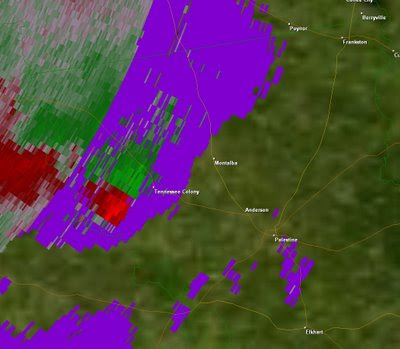
 As we leave Summer and head into fall, we enter a secondary peak in the severe weather season, usually not as great as our primary severe weather season in Spring but, there have been some historical severe weather events across Texas and the United States this time of the year. Over the next few months we will be looking at a few historical fall severe weather events and local fall severe weather events here in East Texas. The fall severe weather season got off to an early start this October as we saw four tornadoes touch down across East Texas on the 6th of October, two near Montalba in Anderson County, one near Bullard along the Cherokee Smith County Line, and one in Cass County southeast of Atlanta.
 An area of low pressure formed across Oklahoma Monday morning and moved east across the state dragging a cold front across East Texas. This brought Southerly winds at the surface and Westerly winds aloft causing the atmosphere to be favorable for rotating thunderstorms and the possibility of tornadoes. The severe Storm Prediction Center outlooked most of East Texas for a slight risk of severe weather and tornadoes.

Around 6 PM a severe thunderstorm developed across over western Limestone county and began to show signs of rotation. This storm continued to move northeast into East Texas, producing three of the four tornadoes for the day. Another tornado formed Earlier Monday afternoon in a severe storm that formed over Cass County.
This week is looking active as well. A strong upper level low pressure system will move north of our region dragging another cold front through East Texas. Right now it looks as though the best dynamics needed for severe weather will move into our region after the cold front moves through, meaning the chances of severe weather are pretty slim however, heavy rain could be a threat with this next system. We will watch it closely because if upper level dynamics move into our area while we are still ahead of the cold front, we could see a round of strong to severe thunderstorms with the chance of isolated tornadoes.
Stay Tuned………………………..

